ROWLING END, CAUSEY
PIKE, SCAR CRAGS, SAIL, CRAG HILL & EEL CRAG from
STONEYCROFT BRIDGE
Summary
Date - 15th June 2010
Distance - 7 miles Ascent - 2900ft
Map - OL4
Start point - Stoneycroft Bridge (NY
232212)
Summits Achieved
Name
Height (ft)
Height (m)
Grid Ref
Rowling End
1421
433
NY 2293 2069
Causey Pike
2090
637
NY 2187 2085
Scar Crags
2205
672
NY 2085 2066
Sail
2536
773
NY 1982 2028
Crag Hill
2751
839
NY 1926 2036
Eel Crag
2649
807
NY 1902 2068
Preface
Apart from Grizzly, who was
watching a television programme with some of his other pals, the
rest of us were discussing the possibilities of future walks.
"Last time we were out with
Uncle Eric, he mentioned to Dad that he would really like to
climb Causey Pike", said Shaun.
"Apart from Little Eric, we
have all climbed it before, back in 2005", replied Tetley.
"That's right", agreed
Shaun. "However Dad took us up the path via Sleet Hause,
missing out Rowling End. It did not matter then, but now we are
doing the Birkett tops, Rowling End needs to be climbed."
"Dad said as much to Uncle
Eric, and he is happy to go up by that route", rejoined
Tetley.
All the while Allen had been
studying the map.
"From Causey Pike, the path
continues over Scar Crags and then down to Sail Pass", he
said. "The tops beyond, Sail and Crag Hill, are on my list
of Wainwrights to do. I wonder if I will be able to tick them off,
as well?"
"It all depends on whether
Uncle Eric feels able to climb that far. You must remember he is
not a young as Dad", chided Tetley mildly.
Shaun piped up, "there is a
bonus if we get to Crag Hill, as then just a little way along is
Eel Crag, another of our outstanding Birketts."
Excitedly Allen interjected, "looking
at the map the difference in height is about 100ft, and there and
back it is just over half a mile."
"Well even if Uncle Eric did
not want to walk there, it would not take Dad very long and it
would be great to get it out of the way", said Tetley.
Little Eric had been sitting very
quietly, taking all this in. "Well, it will be a great walk
for me as I will bag every one. However all this talk is for
naught until we know whether this will be our next adventure."
Looking out of the door, Shaun said,
"here comes Grizzly and he looks excited."
"Hi pals", he said
cheerily. "After we had watched the programme with Dad, he
rang Uncle Eric to discuss walking tomorrow, and they have
decided that we will be climbing Causey Pike and Scar Crags at
least. Dad mentioned the possibility of going further, even as
far as Eel Crag. While Uncle Eric did not rule it out, we will
just have to see how he feels on the day."
"I will keep my paws crossed
then", said Allen excitedly.
The Walk
Up early we all lent a paw to get
our picnic ready, and safely stowed in Allen's rucksack. The
weather was sunny as we set off to drive to Uncle Eric's and
indeed we were to enjoy a glorious day with sunny periods and
hardly any wind. The visibility too was excellent and all the
fells viewable from the summits could be seen, if slightly hazy
at times.
We drove to Uncle Eric's, where we decamped to his car for the rest of the journey.
"Hi Uncle Eric. So nice to see you, and for us to be walking with you today", said Allen.
"Good to see you lads."
Uncle Eric took the route via the A591
to Keswick. Fells tower on either side and we recalled our many
adventures climbing them. Below the Helvellyn Ridge, we passed by
Thirlmere Reservoir.
"It's getting even lower, and
there is not an end in sight to the dry weather", remarked
Allen.
"There will be a hosepipe ban
for sure", replied Tetley.
He was right too, as it was imposed
about three weeks later.
As we neared Keswick, mighty
Skiddaw and its acolytes came into view.
"How majestic it looks",
cried Grizzly. "That was some walk when we climbed it last
September. The summit count was 12 that day."
From Keswick, we joined the A66,
turning off at Braithwaite, then along the road signed Newlands
Pass. This is very narrow, running under the slopes of Barrow,
which we had climbed nearly two years ago.
Shaun said, "we go as far as Stoneycroft Bridge that is our start point. There is parking on the
roadside verge."
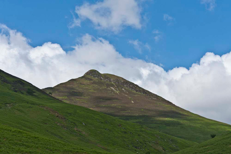
Immediately in front was Rowling
End with its heathery slopes hiding the path we were to take. "There's Causey Pike", said Tetley. "Our second summit, but the first Wainwright of the day."
Eager to be off, we jumped into Dad's
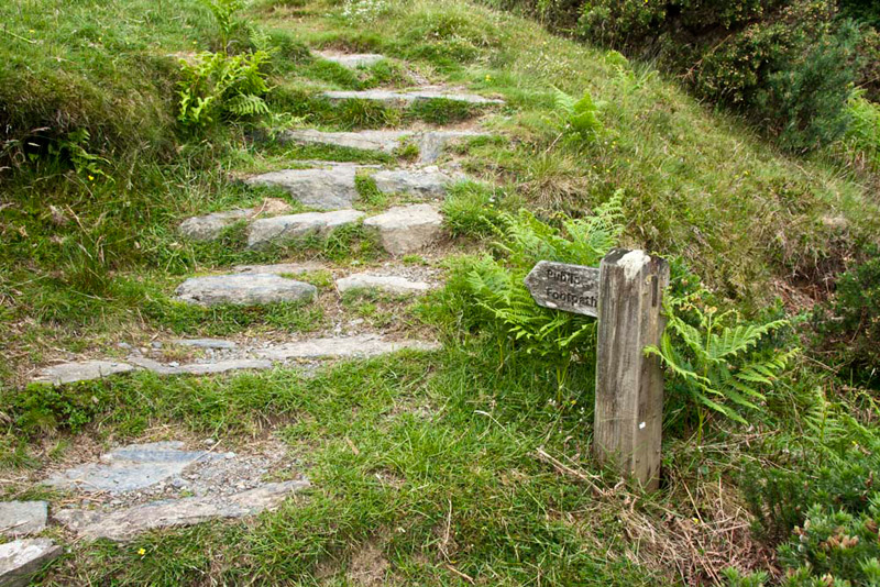
rucksack and got settled. Immediately opposite a signpost,
obviously intended for bears and sheep, indicated our path.
At first through grass and bracken
the path headed steeply towards Elias Crag.
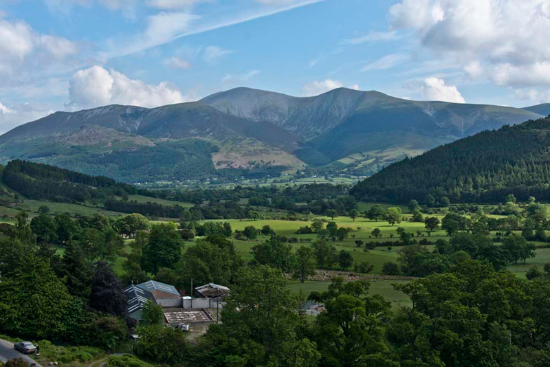
"What a magnificent view of
Skiddaw", called out Allen.
"It just cries out to be
photographed", added Little Eric.
Dad and Uncle Eric were ready to
pause and catch their breath, so did not need a second asking to
get the camera out.
Allen set the scene. "From the left, Ullock Pike, Long
Side, with Dodd in front, then Carl Side, Skiddaw, Skiddaw Lower Man,
Skiddaw Lesser Man."
Notice too the car and man in the bottom left.
This is an elderly gentleman from Ayr in Scotland who doing the
same walk. At different times we chatted during the day.
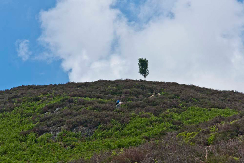
The path rough and stony with bare
rock too, meaning hands were needed at times, wound its way steeply over
Elias Crag, and continued through the heathery slopes above.
"That lonely tree stands out like a sentinel", commented Little Eric. "Even from the road we could see it clearly on the skyline."
Suddenly, the gradient eased and we
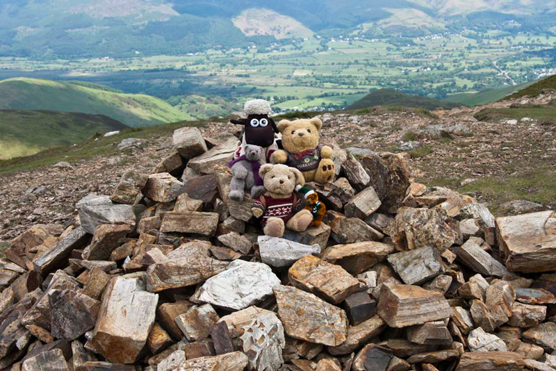
topped out at Rowling End. "Another Birkett done", cheered Shaun.
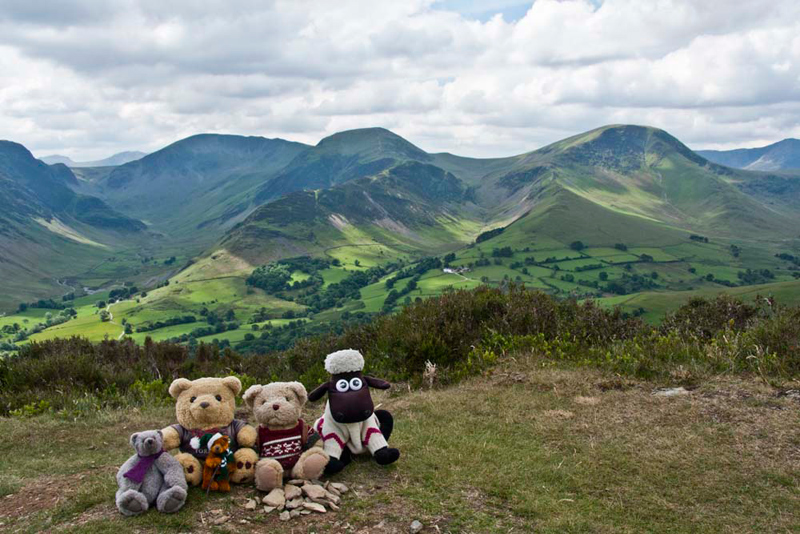
We deliberately sat facing this way
by the tiny pile of stones, as we wanted to get that magnificent backdrop behind us. Grizzly said, "according to Dad's book on Lake District Place Names, "this fells name comes from its association with the Rawlin(g) family."
Picture done we turned and looked in awe at the views. "Incredible", called out Little Eric. "Makes the steep ascent we have done worthwhile."
Tetley set the scene now. "On the
left is the beautiful Newlands Valley, the dominant fell behind being Dale
Head. To the right of the valley is the ridge of Scope End &
High Crags rising to Hindscarth. Robinson is the mountain to the
right with the valley of Little Dale between. We had a wonderful day in July last year, when we climbed them all." Hindscarth
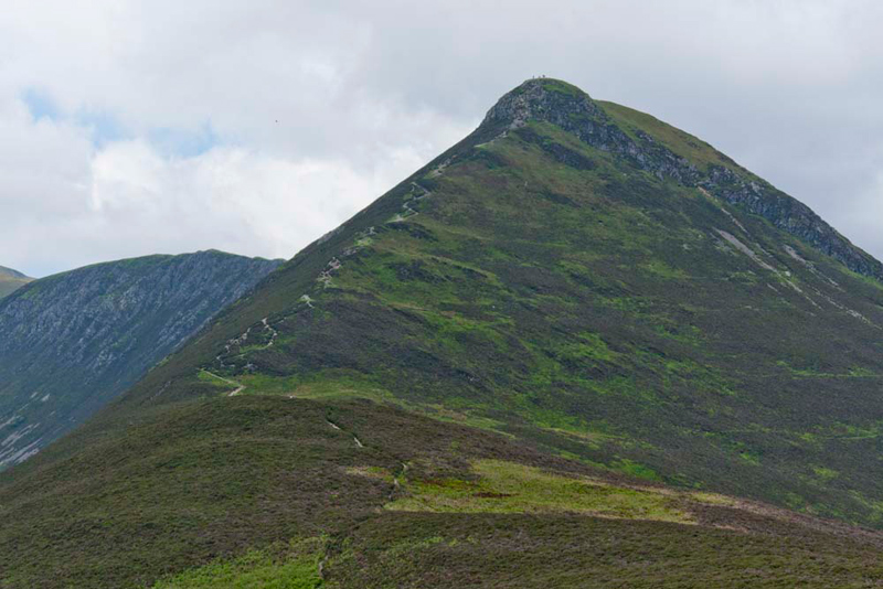
Ahead now was Causey Pike. rearing
up to its impressive rocky summit dome.
"Easy at first across the
shoulder of Sleet Hause, but then it looks to be very steep to the summit", sighed Little Eric.
"We'll just have to take our time", said Dad, "and allow Uncle Eric to stop for rests."
The path as can be see is clear, but it was necessary to use hands
on the last rocky scramble.
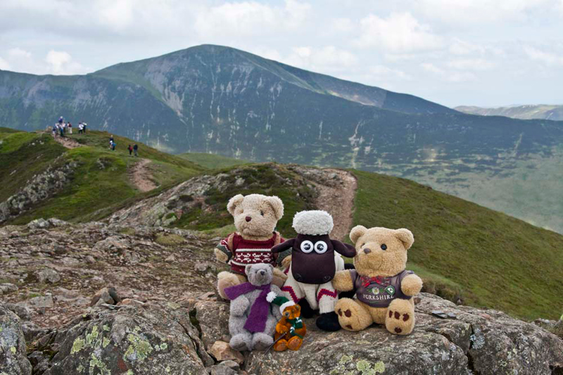
Grizzly said, "to quote Wainwright, 'the top
is quite unlike any other, its narrow crest undulating over five
distinct bumps. The most prominent being the one terminating so
abruptly the eastern end of the crest'."
This is considered
to be the highest point, and needed no prompting we quickly jumped out for our picture.
Busy here too with walkers on the path towards Scar Crags.
Grizzly enlightened us again about the name. "It means the peak by the causeway or paved track. Though not close to it, the mountain may be named from the former Roman road referred to as (le) Cauce/Chauchey etc., in 13th-century documents, which, aided by a stone bridge, traversed the marsh between Derwentwater and Bassenthwaite."
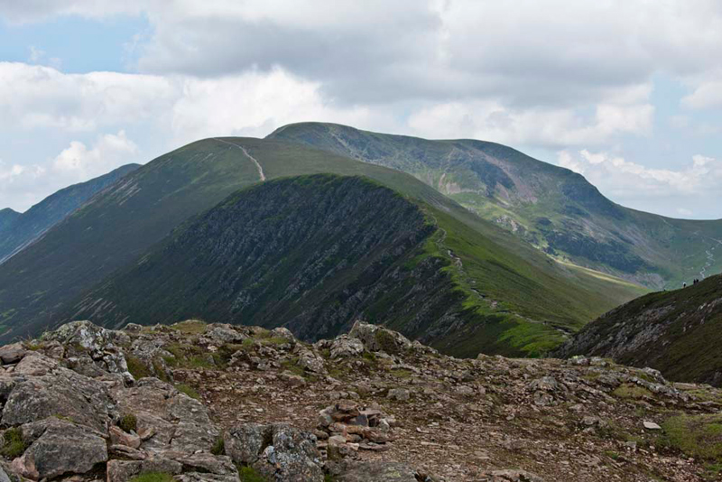
Looking west the succeeding summits, were
laid out before us.
"Scar Crags is immediately ahead, with rising behind Sail, over topped by Crag Hill. Eel Crag is
the slightly lower height on Crag Hill to the right", said Shaun.
"It looks a long way",
said Little Eric.
"Yes and there is lots of
descent and ascent in between each", said Tetley.
"I only have little legs, so I
am glad to be carried in Dad's rucksack", he sighed
Making our way over the bumps of
the cockscomb crest, it was about 150ft down the shoulder,
followed by a 320ft ascent to Scar Crags. Despite impressions
from the previous picture the summit is unexpectedly flat.
"That's two Wainwrights I have caught you up", cheered Little Eric.
A steepish descent led down to Sail
Pass at 2046ft. Ahead was the long 500ft of ascent on a wide
rather eroded gash of a path.
Allen had is paws crossed, as for his and Little Eric's sake, we were hoping that Uncle Eric would
agree to go on. The decision was totally up to him, and after a short consideration and a rest too, he
agreed.
Allen quietly said to himself,
"great", as this and Crag Hill beyond were the
Wainwrights he needed to bag.
Climbing steadily, and resting now and
then, the gradient finally eased and the wide flat top was
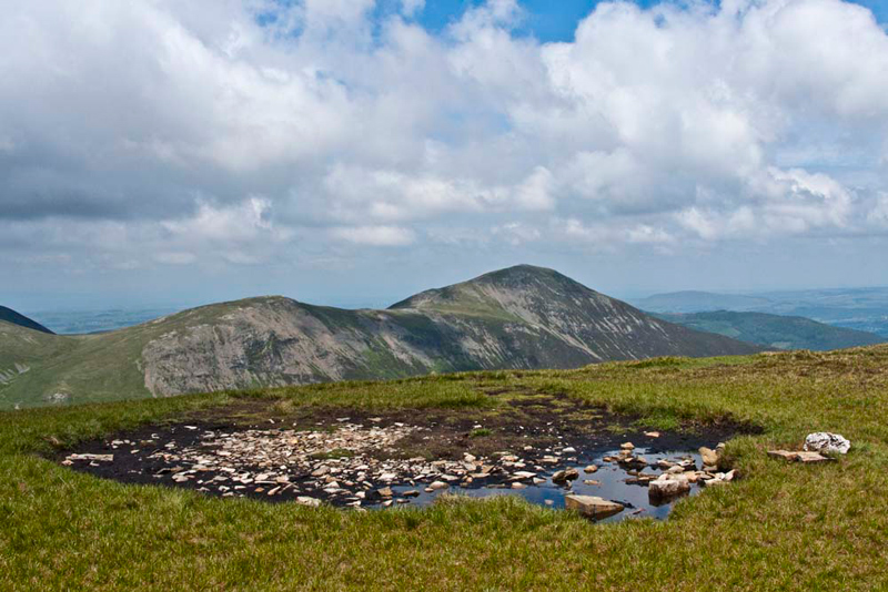
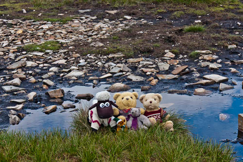
reached. The actual summit is a small boggy patch and pool to the
right of the path.
"There was a cairn in the
centre, when we climbed it 2004", said Tetley.
"The stones seem to have been scattered all over, which is a
shame"
In the background is Hobcarton Head and the higher top of
Grisedale Pike. This latter was to be Allen's
last Wainwright summit.
"We still have to have our picture taken", said Little Eric. "We'll just have to sit on the the grass at the edge."
"The origin of the name is obscure", informed Grizzly. "The most likely seems to be from the the Old Norse seyla meaning 'puddle mire'."
"Seems appropriate for here", replied Shaun.
Ahead was Crag Hill, and having
come so far Uncle Eric agreed to go on.
"Thank you, so much", said Allen with a big smile
on his face.
The path from Sail descends about 100ft to the
connecting depression, followed by an exhilarating climb of about
300ft up the narrow crest, with two rocky rises to its broad top,
where a cairn marks the easing of the gradient. The summit marked
by a trig point is just a short walk bearing half right.
Shaun said, "this
fell appears in Wainwright's North Western Fells book, under the
title Eel Crag. However he acknowledges that the name is
inaccurate, as Eel Crag is properly the rocky buttress above
Coledale Hause."
"Great", called out Allen.
"Now I have just four summits to reach, to finish all the 214
Wainwrights."
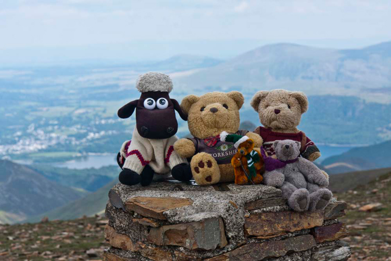
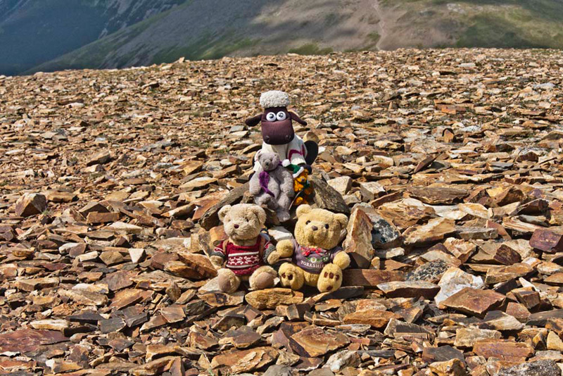
As we all settled on the trig point,
Little Eric, who had bagged the top too, said, "thanks Dad, as
always, for taking our picture."
Uncle Eric had taken longer to reach the summit, by which time we had settled ourselves in the
rucksack again.
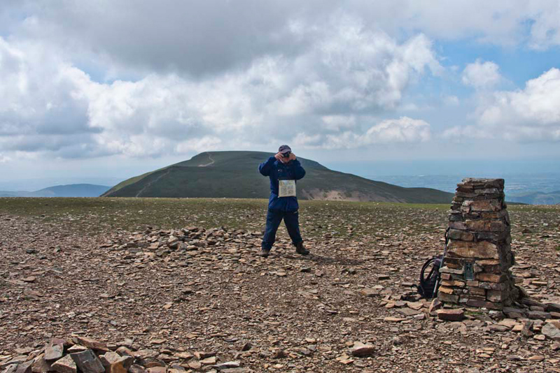
Here is Uncle Eric taking a picture of the trig
point. The backdrop is mighty Grasmoor.
Here too, is perhaps a good point
to say what a social walk this was for Uncle Eric and Dad. First an elderly gentleman from Ayr, who we
chatted to a number of times over the day. Uncle Eric had chatted
to some people from Wiltshire, and on the ascent of Crag Hill to
a gentleman from Devon. At that time Dad was chatting a
gentleman from Blackburn, the town where Alfred Wainwright was
born. He had been to an excellent and entertaining meeting of the
town's Wainwright Society, where the speaker had acted being the
great man. At the summit of Crag Hill we met a couple who like
Dad, Shaun, Tetley and Grizzly had done all the 214 Wainwrights
and were now repeating their favourite tops.
Then Jonathon & Margaret Nason
with their son Robert, who were holidaying here from
Staffordshire arrived. During the lively chat that followed, we
were suddenly noticed, and Dad went on to explain about our
walking and about our website, which they took a note of.
We then heard Jonathon say "my
best friend."
Dad looked a little quizzical, so
he went on the explain. "In the village where we live there is
in July an annual photographic competition, and 'my best
friend', is this years' subject. Can I take a picture with you
and one of the Lads", he asked.
"Of course" replied Dad.
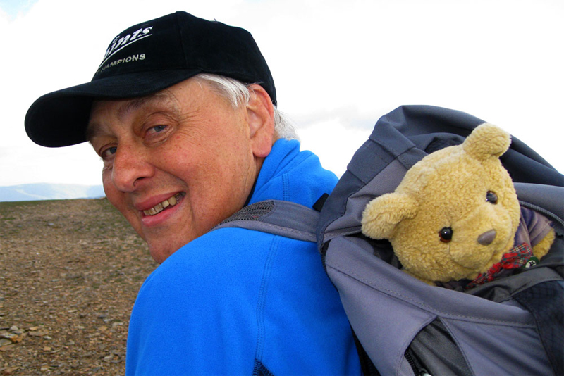
We all jumped out hoping to be the
lucky one, Tetley being selected. Here is the result. We hope he
wins too!!
Photograph
courtesy Jonathon Nason
Jonathon then kindly helped to
settle us all into the rucksack once again. Saying goodbyes they
headed down towards Sail. That was soon to be our route too, but
before that there was the matter of bagging the outstanding Birkett of Eel Crag.
This was a short walk across the fell with a gentle descent of 100ft. As the picture below shows, there is
much loose stone here and the cairn at what we were all sure was
the highest point had collapsed, but Uncle Eric kindly built a
small one for our sake.
"That's very kind", said Allen. "Thank you."
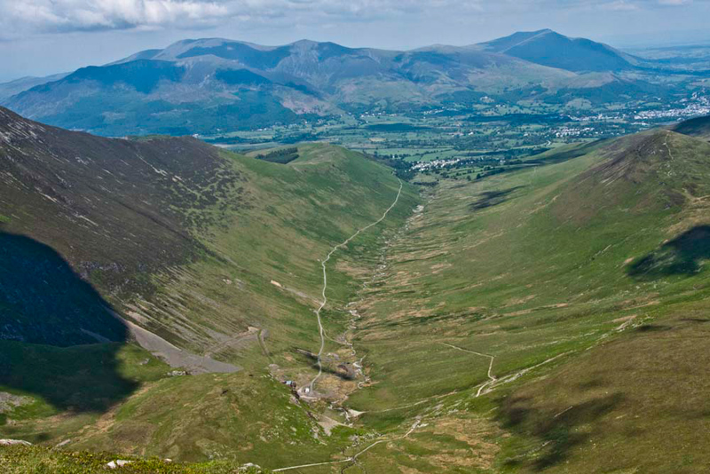
"What a superb view of the Coledale valley", called out Tetley. "On the left side the ridge rises
over Kinn towards Grisedale Pike. To the right the summit in view
is Sail. The whole is backed by the Skiddaw group, with
Blencathra behind on the right."
So that was all the objectives of
the day achieved. Shaun said, "we should return to Crag Hill and then follow the Nason family down towards Sail."
Seeing some convenient rock seats, Uncle Eric said, "good place to sit for a late lunch."
"Ooh yes", cheered Allen. "After all the excitement I am hungry."
"You are always hungry", laughed Tetley.
Setting off we followed the path over Sail and down to Sail Pass.
"We leave our outwards route here", called out Shaun, "taking the path left to descend below Scar
Crags, crossing High Moss under the slopes of Outerside and then along the path in Stoneycroft
Gill."
Here Uncle Eric strides purposefully along.
Shaun set the scene as Dad took the shot. "the fell
immediately ahead is Barrow, which we climbed in July 2008, and
behind that distantly Blencathra. To the right is Clough Head rising to Great Dodd and
in the distance Great Mell Fell."
The path passed below the right
side of Barrow leading unerringly to Stoneycroft Bridge.
"What an excellent
day!!", cheered Allen. "Thank you again Uncle Eric for agreeing to go all the way to Eel Crag."
"You are welcome lads. I am pleased that I made it and have ticked off 4 Wainwrights today."
As we sat in the car for the
journey home, Little Eric wanting clarification asked, "what's the summit count
today",
Allen was quick to reply. "Shaun
Tetley, Grizzly & Dad bagged the Birketts - Rowling End and
Eel Crag. I in addition bagged Sail & Crag Hill, while you
and Uncle Eric, bagged all 6."