We were relaxing chatting over
lunch of marmalade sandwiches and tea.
"These are excellent
sandwiches Grizzly", remarked Tetley.
"Well I use the marmalade that
Dad gets from Mr Williamson at Barbon. This is ginger and you can
really taste the spiciness", he replied.
"It seems we may well have a
new challenge in the offing, as last week I heard Dad talking to
Uncle Bob about where to walk next, and the North Pennines were
mooted", said Shaun.
Yes", agreed Allen, and
continuing, "since then Dad has been doing some research on
the Internet and has found a list on "Go4awalk", of 71
tops.
Little Eric put his paw in saying,
" he also found a longer list on Wikipedia. I saw him
working to cross reference the two and of those over 1000ft (305m),
he reckons there is another 17, making 88 in all, but he needs to
get some extra maps to be able to confirm a definitive listing."
"Looking at the list it will
be quite a challenge as generally they are overall higher than
the Yorkshire Dales, and spread over some pretty wild and
forbidding terrain", interjected Tetley."
"Well it will keep him fit",
mused Grizzly.
"It certainly will", said
Dad as he walked into the room. " I have come to tell you
that having just talked to Uncle Bob, we are walking tomorrow in
the North Pennines. We are going to climb a hill called
Shacklesborough, starting from Grassholme Reservoir, which is
just a few miles from the town of Middleton in Teesdale."
"Hooray", we all cheered
in unison.
"It will be great to have
Uncle Bob's company as it was November when we last walked with
him", said Shaun.
To the Start
It was quite a long drive to the
start, so we had to be up early and settled in the car by 07:30.
Again the route took us north leaving the M6 at Tebay, but
instead of taking the road towards Appleby, we drove along the
road to Brough.
"It is very flat and straight",
remarked Little Eric.
"That is because it was once a
railway line, and when it was closed in the 1960's, this road was
built", said Tetley.
After a while we came to Newbiggin
on Lune, a small village just off the road.
Tetley called out, "Little
Eric , if you look to the left now, you will see a house, that
was once the railway station"
"Oh yes, I see it", cried
Little Eric. "So that was Newbiggin on Lune railway station."
"Well no", replied Tetley.
"Despite it being at Newbiggin, it was actually called
Ravenstonedale, the name of the next village along the road!"
"Mmm", said Little Eric,
with a confused expression on his face.
Soon the road climbed up what is
called Ash Fell, and on through Kirkby Stephen to Brough. Here
going right, it was then along the road towards Middleton in
Teesdale. This climbed ever upwards through wild and desolate
countryside, the snow still piled up at the sides of the road
where it had been cleared by ploughs.
"Not a place to breakdown", remarked Allen.
"Certainly not lad."
The foggy weather at home had given way
to clear skies with frost on the ground, that was until we
started along this road. Now the mist came down making it look
even more forbidding. In fact this was to be the weather
throughout the walk today. After about 10 miles we turned right
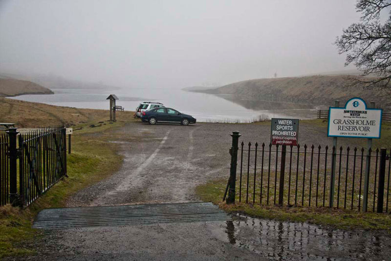
down a narrow road to reach the car parking area at Grassholme
Reservoir, our start point.
Amazingly we pulled in just seconds
after Uncle Bob. "Perfect timing", called out Little Eric.
The Route
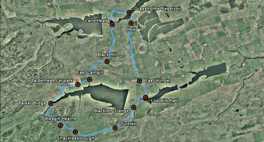
Here is our route. Basically from Grassholme,
we followed the Pennine Way south, almost to Blackton Grange. From
here wild countryside was crossed to ascend to Shacklesborough,
before heading roughly north-west over similar terrain, to
Balderhead Reservoir. Taking the track and then the road on the north
side, it was east above this to East Carnhill, where we headed
north again to regain the start. Read on below to find out about
the various points marked on the map.
The Walk
Dad and Uncle Bob got their boots
etc on, and we settled ourselves in the rucksack, snuggling down
for warmth.
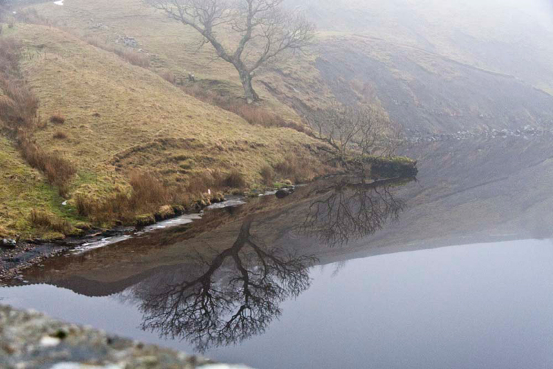
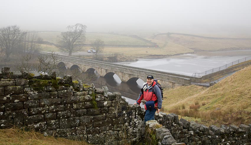
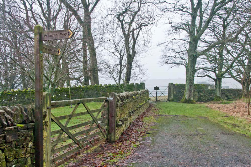
Setting off, Shaun advised, "go left across the narrow road bridge."
"That tree is reflected clearer in the water, than actually seeing it, due to the mist", said Grizzly.
"Now over the substantial stone step stile on the right", pointed Shaun.
The
sign beside it read Pennine Way, and we were to follow this part of the
long distance path for some miles, crossing thirteen stiles in
the process.
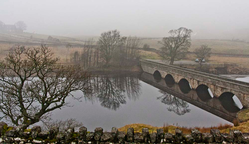
After a few yards, Allen called out,
"there are more lovely reflections in the water, of the
trees and bridge."
At the next stile, as Dad made his
way over, Uncle Bob snapped this picture. What a poser! [Huh, STAG
have no room to talk. Ed.]
Photograph
courtesy Bob Woolley (Uncle Bob)
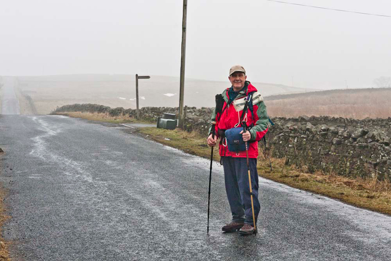
At the road by a house called How, Shaun advised, "we cross and continued on the Pennine Way over the fields to
Kelton Bottom."
Then cutting the corner of a field via two stiles, the Pennine Way led due south down Hazelgarth Rigg, and over more damp pasture to arrive
at the Hunderthwaite to Balderhead road, at East Hunder.
"Uncle Bob", called out Tetley. "Let Dad take your picture here."
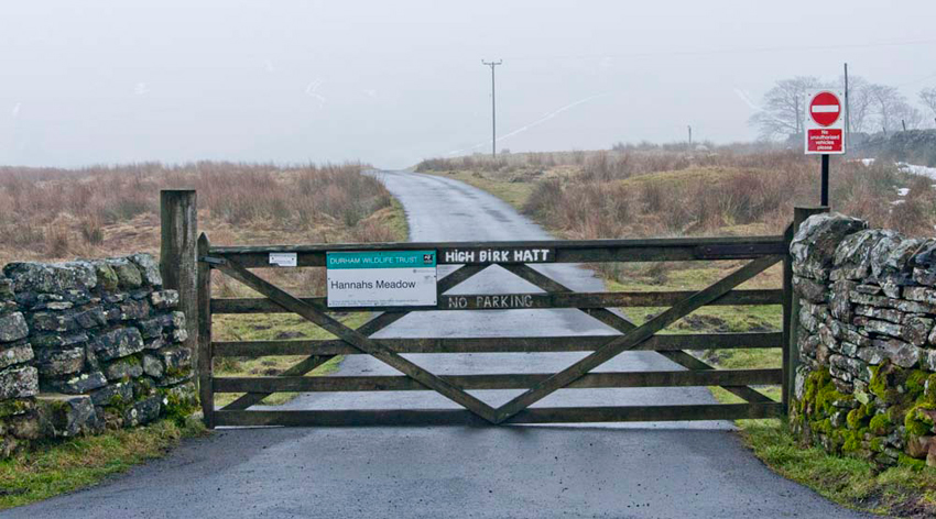
Shaun then instructed, "our continuing route is along the sign posted lane behind Uncle Bob."
Grizzly said, "as well as being the access to High
Birk Hatt, it also leads to Low Birk Hatt, the former farmhouse
where Hannah Hauxwell lived. We will pass her meadow where she grazed
her cattle and sheep."
This is a rare example of a
traditional northern hay meadow. The two hay meadows and a
grazing pasture have always been managed without the use of
artificial fertilisers pesticides or herbicides. The resulting
species-rich meadow contains several plants that have disappeared
from other meadows of Upland Durham, due to intense farming
methods. Because of the presence of species such as wood
cranesbill, globeflower, ragged robin and adders tongue fern,
Hannah's Meadow is now a Site of Special Scientific Interest. The
flowers can be seen at their best in June and July.
It is named after the enigmatic
Hannah Hauxwell whose story became known through a national
television documentary. She lived and farmed the land at Low Birk
Hatt alone without the benefits of running water and electricity
for many years until her retirement in 1988. Durham Wildlife
Trust then acquired the land, to manage it as a nature reserve
preserving the traditional management to maintain the fragile
habitats. The farmhouse, having been renovated and improved, is
in private ownership, and in respect of their privacy, we have
decided not to include a picture.
From the house we continued along
the Pennine Way and through the gate ahead, then on the track
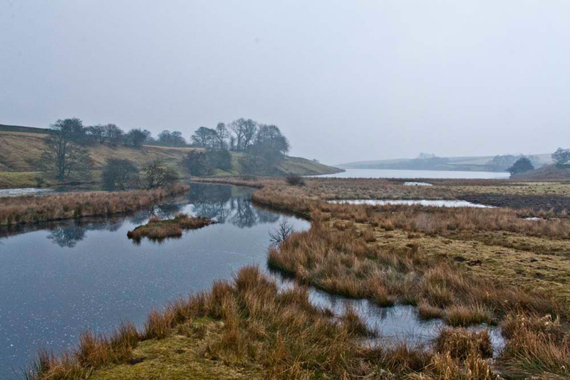
that led above the western reaches of Blackton Reservoir.
It is owned by Northumbrian Water,
and here as well as at other reservoirs they have created nature
reserves. This western end of Blackton Reservoir, at periods of
low water, has exposed mud flats. It is used as a breeding ground
by several species of wader, especially the common sandpiper.
Mallard, wigeon and tufted duck may also be seen here.
After crossing Blackton Bridge, Shaun instructed, "we
finally say goodbye to the Pennine Way, taking the footpath
right and pass by Blackton Grange Youth Hostel."
"Where now", asked Tetley.
"Through this gate on the left,
and up the field and through the wall at the top", replied
Uncle Bob.
A further field followed, to a gate
in the wall. Dad went to open it, trying to free the fastening.
"What's the problem", called out Little Eric.
"I cannot free the fastening", replied Dad. "We'll just have to climb over."
"Not that we haven't done plenty of that in the past", laughed Uncle Bob.
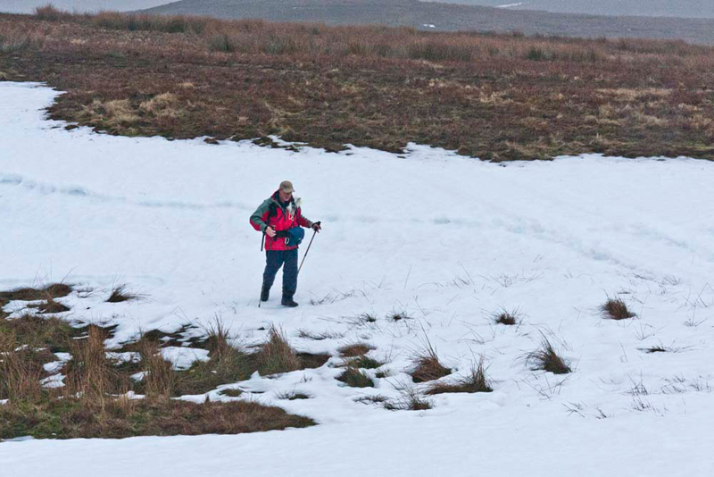
Now on
open fell we climbed to the modest rise of Turf Hill, then
continuing to make the crossing of a deeply snow filled gully.
Dad was ahead and snapped Uncle Bob making the crossing.
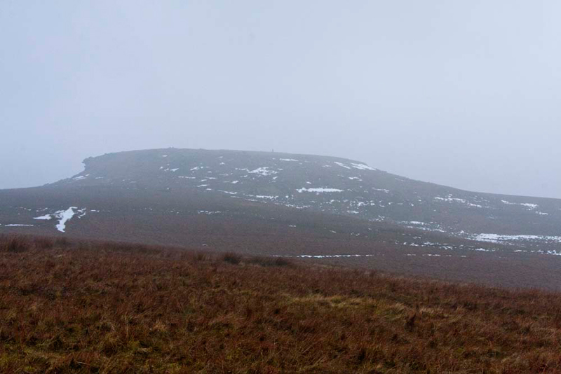
Uncle Bob then took a bearing with
the compass, indicating our direction was nearly due west. The
rounded hump of Shacklesborough soon loomed out of the mist, and
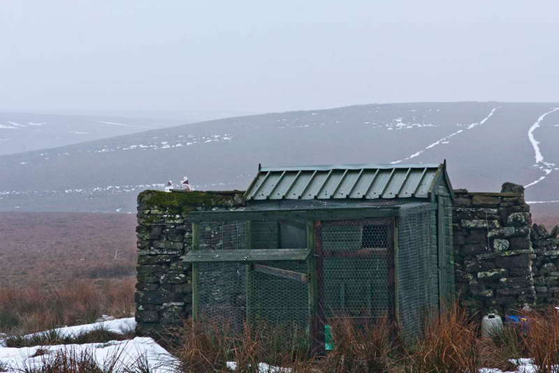
we followed a tractor track heading towards it.
Just to the left
of the track stood the remains of an old stone building and more
modern wooden hut.
"Whatever is that in aid of?",
enquired Grizzly, somewhat mystified.
As we approached closer, Shaun said,
"it's a pigeon loft."
"Seems an odd place for one so
far out in the wilds", remarked Allen.
"Can't argue with that",
Dad replied.
Walking on, the track divided, Shaun saying, "take the right fork."
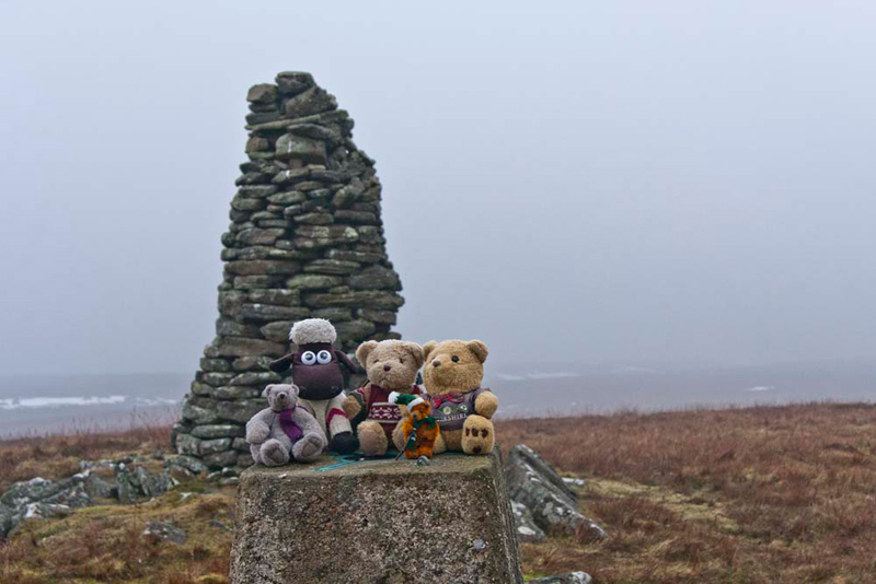
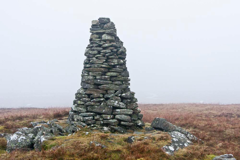
This eventually looped round and ascended
to Shacklesborough's summit marked by a trig point and shapely
tall cairn.
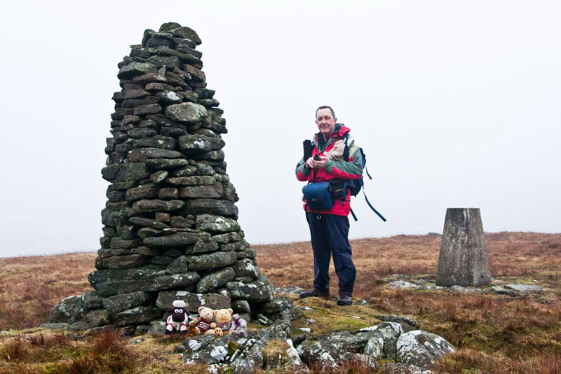
"It must have taken a lot of work to construct the cairn", commented Tetley.
"Picture time pals", called out Grizzly, "Let's settle on the trig point. An important picture too being our first North Pennine summit."
"The cairn is so impressive bearing
in mind the relatively modest elevation of the hill", said Little Eric. "I reckon
it deserves a picture on its own. Also it truly marks the highest
point on the fell."
"Lunch time", called out Allen. "Let's sit by the cairn."
"Good idea", agreed Tetley."
"Lovely sandwiches, Grizzly. "Just what I needed as I'm hungry", said Allen.
"You're welcome pal. Little Eric helped me too."
A couple of mugs of tea also warmed us up for the rest of the walk.
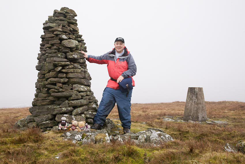
As we made to get into the rucksack Uncle Bob said, "stand by the cairn Gerry and I will take your picture with the lads."
Returning the favour, Dad said, "I'll take you with the lads. Bob."
Then ready for the off, Uncle Bob took a bearing, saying, "we need to aim for that gap in the snow on that
distant hill."
So we confidently set off descending from the
summit. As we reached level ground however the mist thickened,
and we could not see more than 50 yards, never mind the reference
point on that distant hill. The rough moor was totally trackless,
bearing out why it is so important to be properly equipped with
map and compass, and indeed GPS.
After walking for a while Uncle Bob
took another bearing to ensure we were on track, and we finally
reached a stream called Bleagill Hearne.
"That's good. We are on the
right track", remarked Dad.
The GPS gave our position and Uncle
Bob took another bearing for the River Balder and its bridge,
that came into view after a little while, so all was well. It had
been hard going over this section of trackless bog, and at one
point Dad caught his foot in a tussock and he fell full length on
his face.
We were all right and try as we might could not stop ourselves laughing
"The joke is certainly on me", said Dad laughing too.
Uncle Bob commented, "well at
least you had a soft landing!"
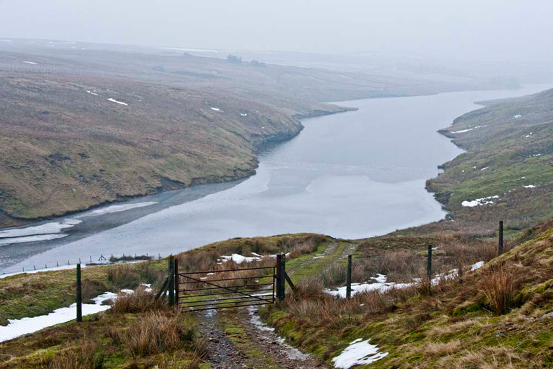
As we descended towards the bridge,
the huge Balderhead Reservoir stretched away ahead into the mist.
Crossing the bridge, Shaun said, "follow the track
heading east above the reservoir."
Part way it looped
round to avoid the large Mea Sike gully, and eventually led to
the road at the parking area.
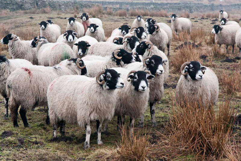
In an adjacent field a flock of
inquisitive black faced sheep came to give us the once over, and
chat to Shaun. "There goes my sheep picture free story again", complained Allen.
"Walk the road to East
Carngill, and there take the path left", advised Shaun.
Shortly Little Eric said seeing the signpost, "this must be it."
The cart
track was followed for a while, before we struck half right to the
boundary wall at Black Hill. Here we climbed the stile and went
roughly north descending the boggy pasture to its bottom right
corner, then on ahead through the gate to Lane Head Farm. Here
joining the access track, we strolled on to the narrow road, and turned right.
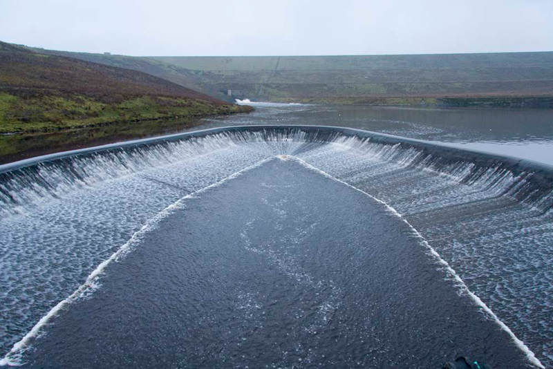
Soon Shaun pointed, "we want that path left."
This descended to
cross Selset Weir. This amazing construction controls the flow of
water from Selset Reservoir into Grassholme Reservoir. "Wow", said Grizzly. "Amazing."
The huge bank in the distance is
the dam of Selset Reservoir, and you can see where the water
comes through via a wide pipe at very considerable force.
Skirting round, the path then
climbed up to a gate and across a field to a stile.
Uncle Bob and
Dad's boots were quite clean up to this point.
"Oh heavens", exclaimed Little Eric. "Just look at the mud in this next field.",
"Due to those horses that are in that adjacent paddock today", went on Tetley.
Thankfully there were some
puddles on the road beyond Low Selset, so they managed to wash
some of the mud off.
"That's the last of the stiles,
and I make it 17 for this walk", said Grizzly.
"I agree", said Allen,
who had been keeping notes.
At the road we turned right and descended to pass
Grassholme Farm to the car park.
"That was a cracking walk", said Allen, "thanks Dad as always and just great to have your company too Uncle Bob."
"Really wild countryside and even in better weather conditions I think that the terrain would
still have been quite bleak", commented Grizzly.
We settled in the car, and after
goodbyes were said, Dad headed back over the road to Brough. It
was very bleak and forbidding through the wild and desolate
countryside, especially as the skies darkened towards evening.
Not surprisingly Dad was hungry, so
he went to Junction 38 Services at Tebay. A large plate of
chicken curry with rice and chips, washed down with tea,
replenished and refreshed him for the rest of the journey home.