BROWNTHWAITE CRAG,
GOWK HILL & RED CRAG from
ST PETER'S CHURCH, MARTINDALE
Summary
Date - 9th May 2010
Distance - 6.5 miles Ascent - 2000ft
Map - OL5
Start point -
Layby opposite Martindale Church (NY
436191)
Summits Achieved
Name
Height (ft)
Height (m)
Grid Ref
Brownthwaite Crag
1457
444
NY 4430 1734
Gowk Hill
1545
471
NY 4448 1669
Red Crag
2333
711
NY 4503 1518
Preface
It was Friday
afternoon and over a mug of tea and chocolate biscuits, we were
chatting about the previous day's adventure.
"It was a great
day for you Allen", remarked Tetley.
"Yes it certainly
was. I ticked off a third of my outstanding Wainwights. Now with
only eight to go, I really feel that I will achieve completion of
the challenge this year", Allen replied.
Grizzly piped up,
"the views were wonderful. Ullock Pike was my very first
Wainwright, which I climbed in July 2004. I had forgotten what a
super walk that ridge is."
Ever practical, Shaun
mused, "I wonder whether Dad will take us out on Sunday?"
Little Eric replied,
"if you give me a ride on your back I will go and ask him."
So off they trotted.
Presently returning,
Little Eric said excitedly, "yes a walk is on."
"Where to",
interjected Tetley.
"Well, Shaun
reminded Dad about that walk from Martindale, to climb
Brownthwaite Pike & Gowk Hill and then up to the ridge above
to bag Red Crag", Little Eric went on.
"Those are
outstanding Birkett tops, which Dad has been meaning to take us
to for a while, but for various reasons he had had to defer the
walk", said Allen.
"Well it will be
great to finally get them done, so roll on Sunday", called
out Shaun.
The Walk
To get to the start we left the M6
at Penrith and took the ever familiar A66 west towards Keswick,
very soon turning left by Rheged along the road to Pooley Bridge.
On the way we passed a man driving an old tractor.
"I wonder where he is going?",
said Tetley.
Just then we came to the stately
home called Dalemain, and Shaun called out, "he's going here,
as there is a vintage tractor rally today."
"Just look at that line up of
old tractors", called out Allen, as we passed by.
"Wonderful", replied
Grizzly.
Soon Ullswater came into view and
we turned left along side, then right over the bridge into the
village of Pooley Bridge. It was straight on to the crossroads,
where we turned right, to drive the at times narrow road along
the east side of the lake. We passed the entrance to Sharrow Bay,
a very exclusive hotel, then continued to Howtown.
"This is one of
the places where the Ullswater Steamers that ply the lake stop", said Grizzly.
"Very popular with walkers, who sail from Glenridding to here,
then walk back by the lake under the slopes of the dominant hill
Place Fell."
Dad drove on, and soon we were climbing the narrow
steep curves to reach St Peter's Church, Martindale our start
point. As he drove up we were rewarded with a view along the lake
with the steamer making its stately progress to Howtown.
Unfortunately Dad was not able to stop to take a picture.
Dad parked in the layby opposite
the church, under the slopes of Hallin Fell. There were quite a
few other cars there with people getting ready to set off too,
and we saw some start along the wide clear path up Hallin Fell. "Nearly five years since we climbed that", said Tetley.
"If I am ever to complete the Wainwright challenge we will have to climb to its summit again", remarked Little Eric.
By now Dad was ready and we had
hopped into the rucksack and got ourselves settled. We walked
past the gate to the church, to gain the open fell.
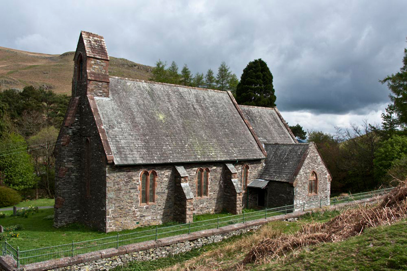
Allen then immediately called out,
"that will make a nice shot of the church to start our story."
"OK", replied Dad,
hauling the camera out of its bag.
"I have some notes about the church", said Grizzly. "It is often referred to as the 'New Church' to avoid confusion with St Martin's Church, the 'Old Church' and former place of worship of Martindale, which lies half a mile further up the valley. Construction of St Peter’s began in 1880 on an acre of common land at the top of the hause. The main financial backing for the building came from Anthony Parkin of Sharrow Bay and W.H. Parkin of Ravencragg who were both local residents. The architect was J.B. Cory and the builder was Edward Peel of Patterdale who utilised the stone from the surrounding fells to construct the church in the Early English Style. The church, which was consecrated on 6 January 1882, consists of nave, chancel with vestry, bell tower and an entrance porch facing south-west. The church is Grade II listed."
Shaun instructed, " we go right on the path that makes a high traverse under the craggy lower face of Birkie
Knott."
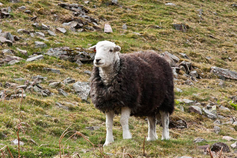
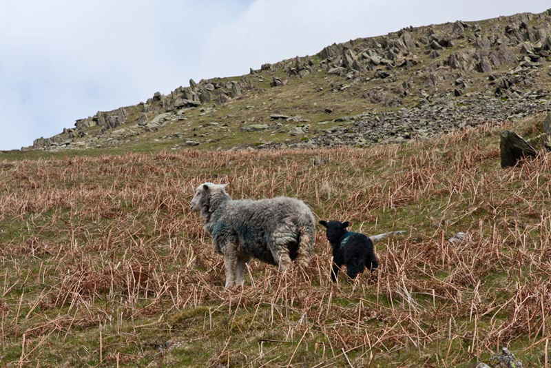
On the fellside and in the fields below were many of our
beloved Herdwick sheep, and when one stood and posed, Tetley said, "you will have to take a picture Dad."
The path continued above the wall,
to a point where it dropped away right, high above the old church.
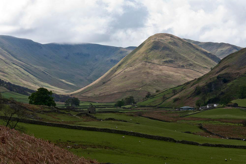
"Wow", called out Allen. "What a wonderful view over Martindale. That is The Nab rising in the centre, and is part of
the Martindale Deer Forest. On the occasions we climbed
to its summit we were fortunate to see some of the deer. To
the left is the valley of Ramps Gill, rising to Ramps Gill Head,
whose top is just covered by cloud."
Now, Dad is very experienced on the
fells, but he freely admits that occasionally he does make mistakes with
route finding. Here was one of those occasions.
What we should have done was walk on ahead for
a short distance to find the path rising from the right. Instead
we descended to the valley floor, and then followed a path right
by the wall. This in itself was in fact fine as we were heading
in the right direction, albeit at a lower level.
"Oh dear", said Shaun, "we are too low down."
"I know", agreed Dad. "We should have kept ahead. I did not read the instructions carefully enough in Bill Birkett's Almanac."
"The OS map
shows a path rising up the hillside", said Allen.
Dad took this, but the map does not show zig zags, so we got off course again. "I'll just climb straight up the rough fellside." said Dad.
There, after climbing the fence, we regained the proper path.
"Well it has added to our
adventure!", said Little Eric.
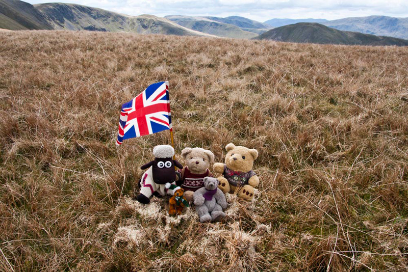
On this path we now made good
progress and soon the first summit of Brownthwaite Crag was
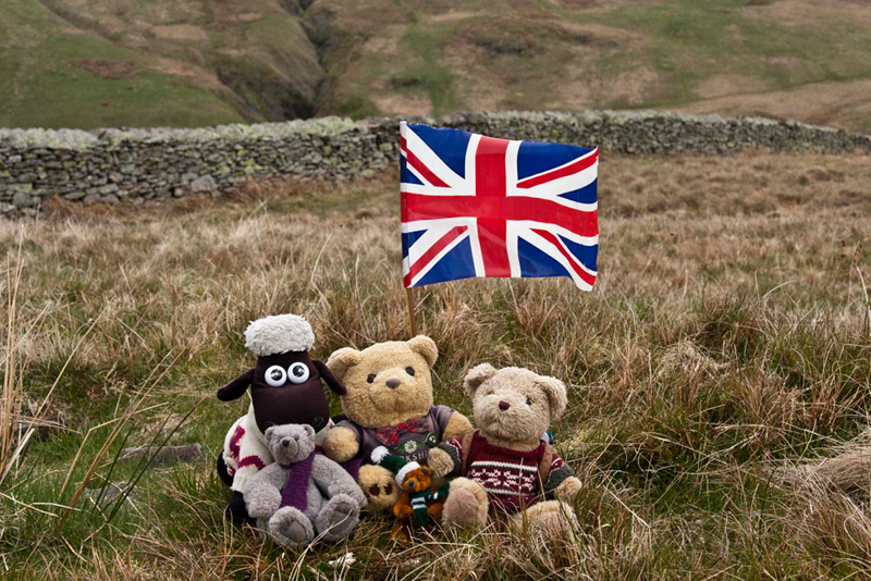
reached. "Those few stones almost lost in that small boggy depression
must mark the summit", pointed Grizzly.
In fact we were to find that none of the summits had cairns, much to our disappointment, so to please us Dad got the flag out to
brighten the picture.
"Where to now?, asked Little
Eric.
"We continue south to cross
the path that circles the fell and then climb directly up the
hillside to Gowk Hill", replied Shaun.
So down we went crossing the
depression and soon we were climbing the slopes to the wide grassy area with two mounds at its summit.
"The west one has a
few stones at the spot height marked on the OS map", pointed Allen.
"Yes lad", agreed Dad, "but the east top is slightly higher according to the map."
So we walked the short distance to
it and found the lone stone marking the summit. This can be seen behind Allen.
To the east stands the ridge
running north from High Raise over Loadpot and Wether Hill,
along which runs the remains of the High Street Roman Road. Dad
had taken us along various sections before, but this was
prior to knowing about the Birkett Fells. As a result one top,
Red Crag, had not been visited, so we resolved to tick it off
today.
Shaun said pointing to the map, "we have to descend east and cross to the base of
the ridge to pick this dotted path."
This climbed
quite steeply across the face of the ridge, finally gaining the
path that is on the course of the Roman Road.
Rounding the wall that path then crossed through the wall, Shaun saying, "we should traverse diagonally to the fence and climb on beside it to Red Crag."
The cairn came into view, on the far side, so
Dad climbed the fence to reach it.
"Made it", called out
Tetley, as we prepared to decamp from the rucksack.
"Hang on a minute", cried
Dad. "This is not the summit."
"Where is it then", said
Allen, sounding rather exasperated.
"Just on that next rise to the
south", replied Dad patiently.
In a minute we were there, and
hopping out of the rucksack, settled on the ground for our picture. "If only that cairn had been here", sighed Little Eric.
"I wonder what the origin of the
name is", mused Tetley.
"I looked it up in Dad's book on place names", replied Grizzly. "Apparently it is because the craggy outcrops on its western face have a reddish colour."
"For a change there are good
views today", remarked Allen.
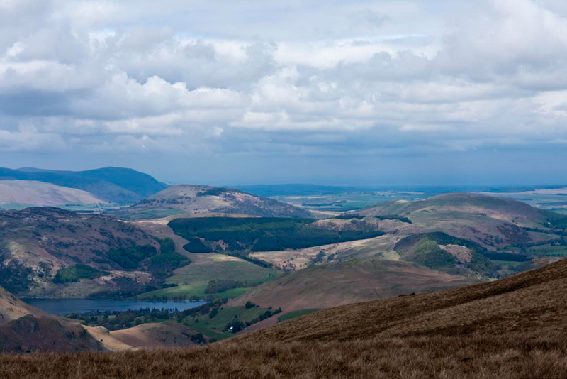
"Yes", replied Shaun.
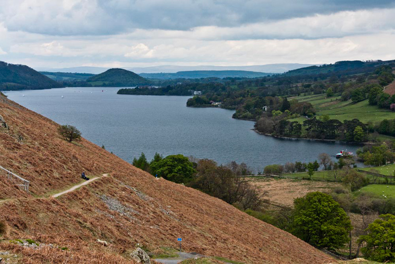
Then continuing, "I think that view to the north is worth a
picture. The lake is part of Ullswater with
behind from left to right Gowbarrow Fell (1579ft), Great Mell
Fell (1762ft) and Little Mell Fell (1657ft). More distantly
behind Great Mell Fell, the dark hill is Carrock Fell (2174ft),
the ridge from it running left to High Pike (2157ft)."
"I remember the snowy December day when we climbed High Pike", said Grizzly. "We sat on the snow
covered seat to have our picture taken."
Ready to set off again Allen
remarked, "there seems to be a good path on this side of the
fence."
"Your right, and I intend to
use it for our return route", replied Dad.
It ran straight and true leading to
the wall above Mere Beck. A gate on the right provided a way
through the wall, then crossing the ravine we regained the ascent
route.
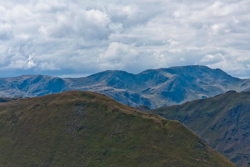
We stood a while looking at the wonderful view of the
fells to the west. "Breathtaking", said Little Eric, "please take a picture Dad."
"That is the highest part of The Nab in the foreground", said Grizzly. "Behind from left to right is Dove Crag, Hart Crag and Fairfield, some of the fells that form the Fairfield Horseshoe."
Following the path down, Shaun said, "if we cross that rough ground we will pick up the excellent wide smooth grassy
path that skirts left below the summit of Brownthwaite Crag."
Further on it passed through the wall and under the slopes of
Steel Knotts. Here we saw more of our lovely Herdwicks, including
this ewe with its almost totally black lamb.
This led to our outward path above
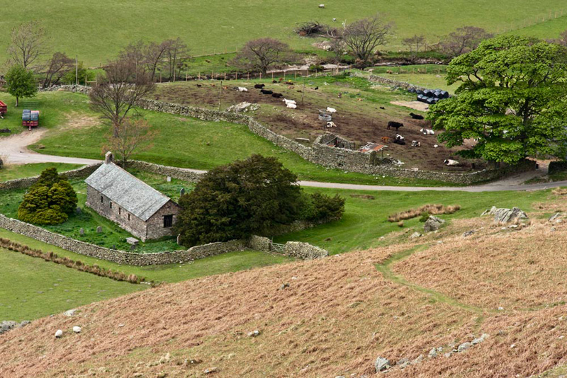
the wall towards Birkie Knott. Here looking down we could see the
old church, St Martin's.
Finding his notes, Grizzly told us, "the date of the establishment of a place of worship on the site of St Martin's is unknown but it is mentioned in a de Lancaster Charter of 1220 and other references state that a chapel was already in existence at that date. In its early days and up until the Dissolution of the Monasteries in 1536 St Martin's was served by the monks of the parish of Barton. In 1633 the parish of Martindale was founded and Richard Birkett became the church’s first resident priest. He served until his death on Christmas Day 1699, after a ministry of almost 67 years. The present building was probably erected at the end of the 16th century, replacing the chapel, the last reference to which occurs in a document of 13 April 1541. In 1714 the church floor was flagged as the congregation were no longer prepared to endure the damp earth floor. In 1839, William Ford, in his book 'Description of Scenery in the Lake District' described the building as 'a chapel with low roof and simple bell-gable, and a picturesque yew-tree'. The church underwent a series of restorations, the last of which was in 1882 when the roof was replaced, the old box pews were removed and the same wood was used to construct the side benches. The singers and musicians gallery was taken down and new window frames installed. The tiny church bell which hangs in an open cote at the west end of the church is over 500 years old. It is inscribed with Lombardic characters which have not yet been deciphered. The ancient Yew Tree in the churchyard is estimated to be 1300 years old, and documents in the church state the men of Martindale, who were famous as bowmen used the tree and others in the district to replenish their arms."
"Thank you pal for the history lessons today. It adds lots of interest to our adventure", said Little Eric.
Returning along the path under Birkie
Knott, we soon reached the car, where settled on the front seat
ready to have the rest of our picnic.
Dad got his boots off, then
headed down the steep road. "The view along Ullswater is
beautiful", said Allen.
"I can pull off here to take a shot for your story", he replied.
"A steamer is docked at Howtown Pier", called out Tetley. "The prominent
hill at the top of the lake is Dunmallat one of the Wainwright Outlying Fells, that we climbed April 2007."
Little Eric said, "that was before I was born."
"Another excellent day and three
more Birkett tops ticked off", cheered Allen. "How lucky we are to go on all these adventures."
"Yes we are", went on Shaun. "Thank you Dad as always."