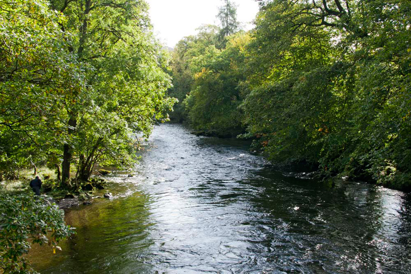
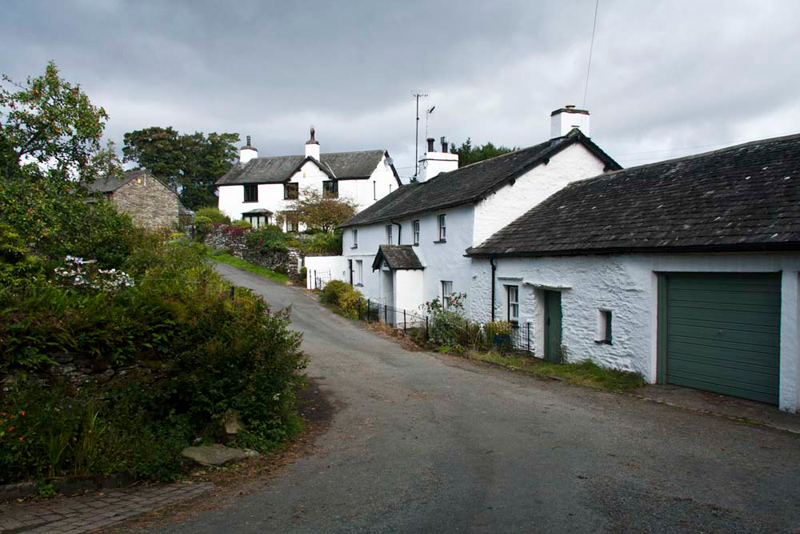
Beside A593 Nr
footbridge over river at Brathay (NY 363034)
Preface
"What a week so
far", complained Grizzly, who was staring glumly out of the
window, as the rain beat against it, in another torrential
downpour.
"We would be
soaked in seconds", replied Allen.
Tetley was sitting in
front of Dad's laptop, looking at the Met Office forecast for the
Lake District. "On Thursday, when we have a walk day with
Uncle Eric, the weather looks to be mostly dry, but the winds on
the fells are still gale force with even stronger gusts."
"It doesn't sound
too pleasant, and it would be very hard going for Uncle Eric",
replied Grizzly.
"It would be a
better idea to do a low walk", said Allen. "After all
we do not need to necessarily be on the high fells to get good
views."
During these exchanges
Shaun, with Little Eric riding on his back, had wandered in.
Little Eric said,
"I agree, your ideas make sense."
We all then gathered
round Dad's laptop, while Tetley navigated the folders to show us
the results of Dad's photographic efforts on the recent walks.
"There are some
good shots and they give a good record of the adventures, which
will be great to look back on in the future", mused Grizzly.
The next day, we were
sitting reading the book by Bill Birkett on Scafell, when Dad
wandered in. "I have spoken to Uncle Eric about walking
tomorrow. The winds are still forecast to be very strong on the
fells, so it has been decided to do a valley walk. We will be
walking in the Skelwith area and round Tarn Hows.
"Haven't Shaun
and I done that before?", asked Tetley, who has a phenomenal
memory of past adventures.
"Yes",
agreed Dad. "We did it in June 2002, but much of the detail
has faded over time, and it will be a completely new adventure
for Allen, Grizzly & Little Eric."
"Can't wait",
shouted Little Eric, excitedly.
The Walk
Dad drove us to Uncle Eric's, where
we decamped to his car.
"Good morning Uncle Eric", said Allen, on behalf of us all. "We are looking forward to the walk and so nice to have your company."
"Hello lads, good to see you too. We are lucky to get out this week, with the weather being so unsettled."
The drive was about 10 miles via
Windermere and Ambleside, to the start point on the A593 at the
boundary between Brathay & Clappersgate.
Dad and Uncle Eric soon ready, and us snuggled in the rucksack, we set off, Shaun directing, "cross the road and in a few yards fork left along that
path, and over the bridge that spans the River Brathay."
"It is flowing quite fast", commented Little Eric. "Hardly surprising after all the rains this week."
This led to Bog Lane, where almost
immediately we went left through a gateway.
"Were going the wrong way",
called out Shaun, who was scrutinising the map.
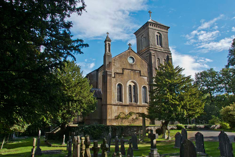
"Yes, I know we should
continue along the lane but we are going to have a look at Holy
Trinity church, first", replied Dad.
"I have researched about this", said Grizzly. "William Wordsworth wrote: 'There is
not a situation outside the alps or among them more beautiful
than this'. He is describing the top of a small rugged hill,
among trees and high above the River Brathay - the site he
suggested for the building of the church. The space on the summit
is so limited that the dramatic church is orientated
north-south rather than customary east-west. It is built in the
Italianate style by the
Redmaynes of Brathay Hall and was consecrated in 1836. The Redmaynes
made their fortune in the Italian silk trade, which may explain
the style of the Church. The burials in the sloping churchyard
are of the clergy facing west and the laity east."
"Thank you pal", said Tetley. "There is no
doubting the beautiful and tranquil situation."
We took this in a little longer, Allen then saying, "time to be getting on now."
"Yes, you're right", replied Uncle Eric.
So, we returned to the lane, and turning left strolled along to the buildings of Jeffy Cottages. "We take the permissive path right through the deciduous trees,
beside the fast flowing Brathay", said Shaun.
This lovely path brought us back onto Bog Lane that we continued along.
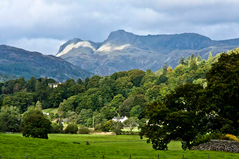
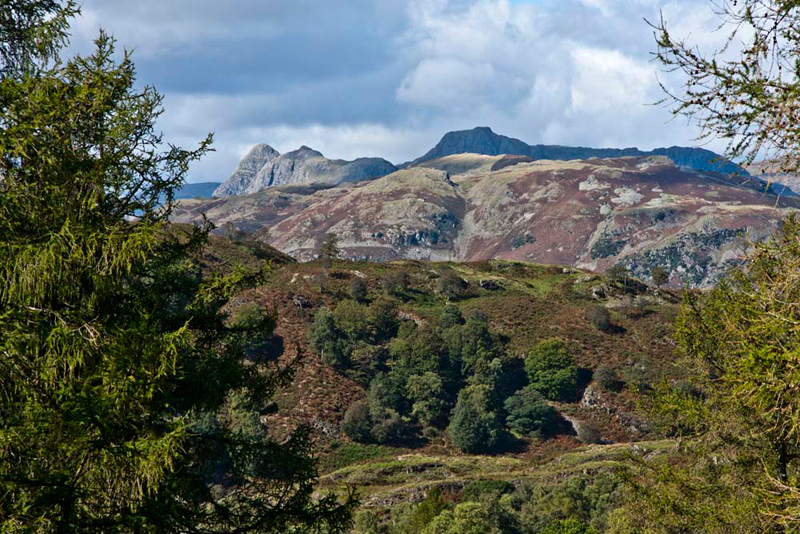
Suddenly the view opened out, Allen shouting, "wow what a superb view of the Langdale Pikes. I like the way that patch of sunlight
is falling across the mountains."
"Before you ask, yes I am
going to take a few pictures", said Dad, knowing full well
what Allen is like.
The quiet lane led to the pretty
hamlet of Skelwith Fold. There Shaun advised, "our route is the lane signed
Hawkshead."
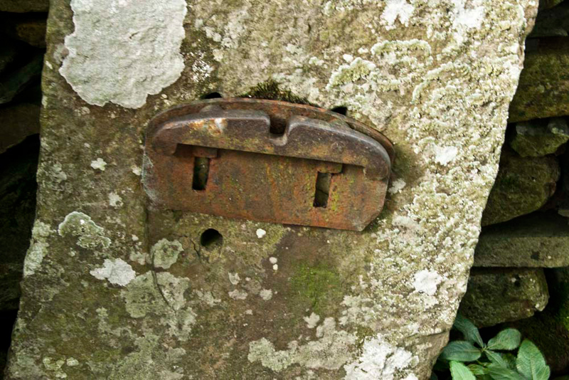
As we ambled along it was plain to see that long ago, there had once been at intervals gates
across this lane, for reasons that Uncle Eric and Dad could not
properly work out. While the gates had been removed the old
lichen encrusted stone slab posts still survive with
the fastening for the latch to sit in.
Below Pull Scar, the road turned
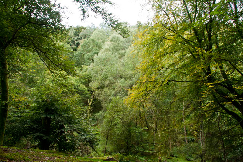
sharp left. Looking at the instructions, Grizzly said, "we leave the road and go ahead through that gate, to walk the good
track that climbs through the glorious woodland of Pullscar
Plantation."
"Just look at the view to the
right", called out Little Eric. "There are so many
different greens in the trees."
"Oh yes", replied Dad.
"I'll stroll on while you
frame the shot", said Uncle Eric, after having surveyed the
scene. "You are faster on the uphill sections."
Exiting the woodland, the path led
on, muddy at times after the rains earlier this week, to come to
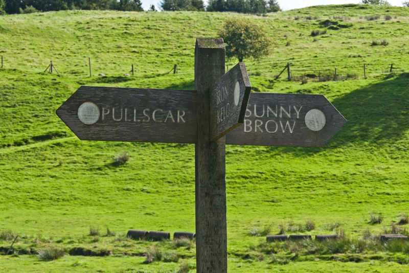
an excellently signed junction.
"Our route is on ahead to Sunny Brow", advised Shaun. "We could follow the path to Iron Keld, as we will pass its other
end later, but doing so we will miss out on Tarn Hows."
At Sunny Brow, we joined another
narrow lane that led through the hamlet of Knipe Fold.
Coming to the next junction, "take the right fork up the steep hill", called out Shaun.
"Well, the sign does say that we are at Hawkshead Hill", laughed Allen.
This led past the gallery and tea room of Betty Fold.
"That's one you have not
visited before Dad", chimed up Allen.
"It's also too soon to make a
stop", added Shaun.
"OK", said Dad rather
downheartedly, marching on past.
"Well it's one to remember to
bring Uncle Brian, sometime", said Grizzly, helpfully.
"Ooh yes", replied Dad,
his face brightening.
Shortly a signed track went off right. "That's our route", called out Shaun.
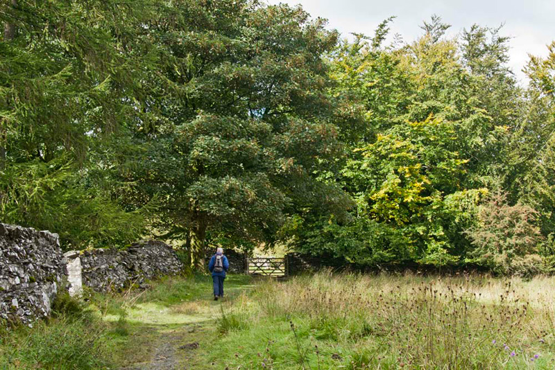
This took us past the cluster of houses called Yewfield, where the rough track climbed to a gate on to open pasture, where Uncle Eric strode on towards another gate beneath more glorious trees.
Shortly beyond the gate, at a cross
of paths, Shaun instructed, "it is over that stile on the right."
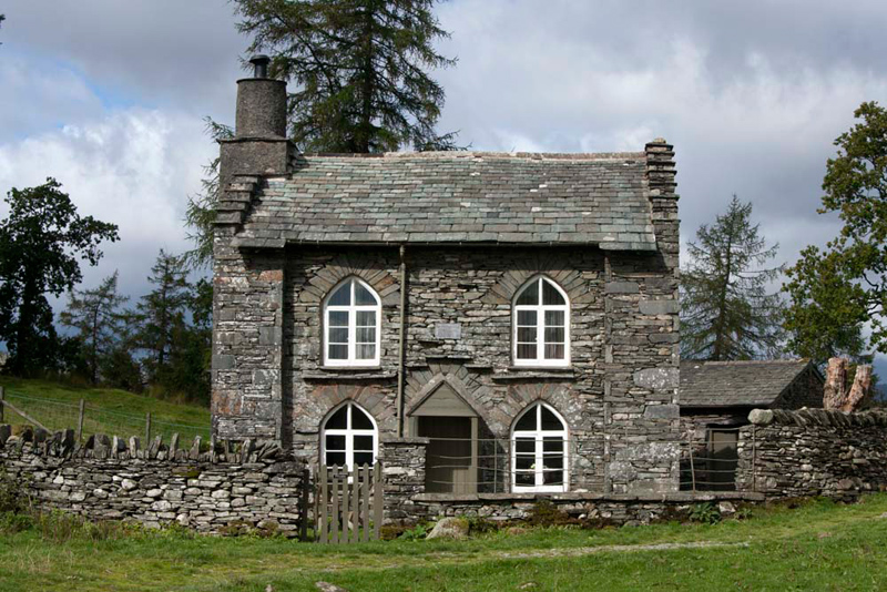
Beyond the narrow grassy trod, led past Rose Castle, a tiny house belonging to the
National Trust. "It was built in the 19th century, and is grade II listed", informed Grizzly.
The path wound behind the house and
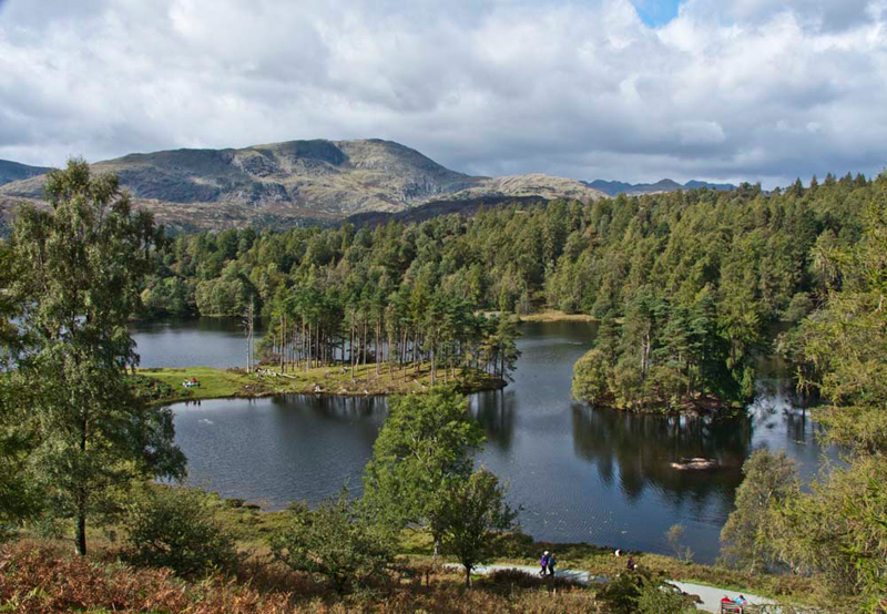
as it started to descend, suddenly below us was Tarn Hows. "Wow, what a view", cried Little Eric.
It is one of the most popular tourist places in the Lake District,
and one of the most photographed too. Dad snapped off a few shots, this we considered being the best. Well it's our story after all.
"That's Wetherlam behind",
said Tetley. "We last climbed it in July 2008, via the steep
slope on its right, Wetherlam Edge."
"I had forgotten that it was
over two years ago. My how time flies", added Allen. "We
did a story about that adventure too." Wetherlam
Little Eric, who is not as familiar
with the fells as the rest of us asked, "what is the
mountain away to the left beyond Wetherlam?"
"Coniston Old Man with Brim Fell to the right",
replied Shaun instantly.
Up to now we had seen only two
other walkers today, but descending to the tarn and proceeding
round it, there were people everywhere, which was hardly
surprising. Some of the groups talked in loud voices, rather
shattering the peace and tranquility. We were to be glad when we
finally got away from the tarn area.
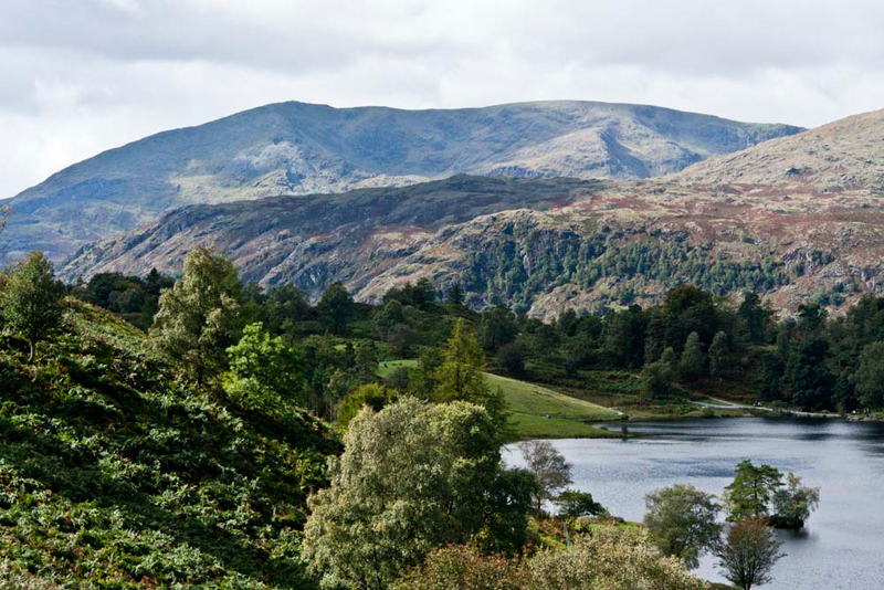
Strolling down the path rounded the head of the tarn below the narrow road. "Another beautiful view", breathed Little Eric. "I can see why it is so popular."
Proceeding on the path along the west side, we passed the signed path to Glen Mary with its lovely
waterfalls.
"We walked down there on an
adventure in November 2007", said Tetley.
"Oh yes", replied Shaun.
"We climbed Holme Fell and Black Crag that day too. It was
very misty and navigating to the tops was rather difficult, but
we made it."
A little further on there was a
free seat. "Good place to stop of lunch", suggested Uncle Eric.
"Oh yes", agreed Allen. "I'm hungry as usual."
Here it
came on to rain, but it was not too heavy so we did not get very
wet. The shower soon passed over and it was dry again for the
rest of the walk.
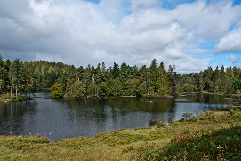
Continuing on, as the head of the
tarn was reached, Shaun advised, "we leave the 'round the tarn' path, to
take the track heading north."
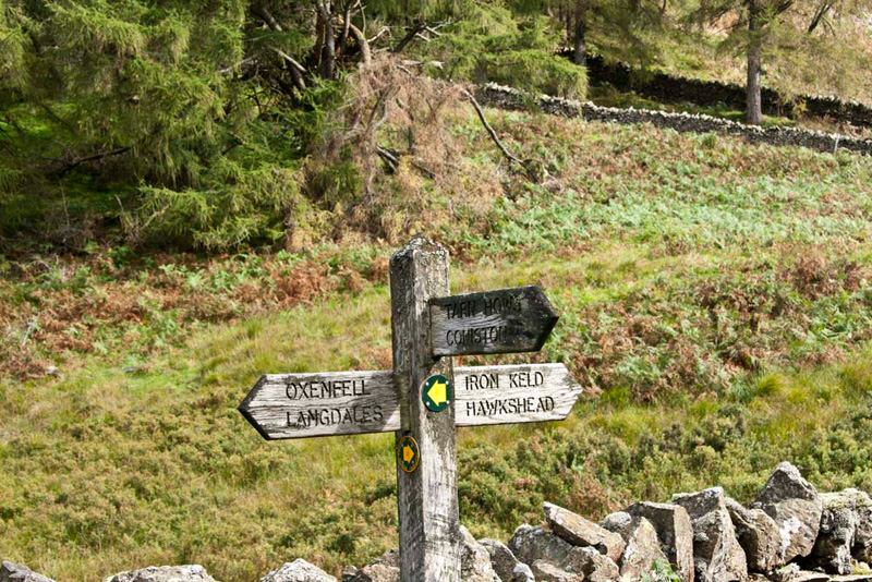
This led to a gate on to a wide
track, where another substantial signpost, clearly displayed the
route options.
"Which way now?, asked Grizzly.
"Right in the direction of
Iron Keld", replied Shaun, consulting the map.
The track wound on, a gap in the
trees affording another fine view to the Langdale Pikes.
"That will make a good picture
for our story", called out Allen.
"I know", replied Dad,
hauling out the camera.
Setting the scene, Tetley said, "the sun is shining on Pike o'Stickle
and Loft Crag. Then right, just in the shadow
is the lower summit of Thorn Crag, with in full shadow
Harrison Stickle and Pavey Ark. The bare fell
in the foreground is Lingmoor that lies on the opposite
side of the valley of Great Langdale, from the Pikes."
Walking on, we finally came to another junction. "We go left through the gate into Iron Keld
Plantation", said Shaun.
"The name means Iron Spring'", informed Grizzly.
The wide track proceeded through the plantation, although the
trees had been considerably thinned out. After a straight
section at first, it then wound through a few bends to reach yet
another junction. "The path coming on from the right is the opposite end of the path from the junction on the track from
Pullscar to Sunny Brow", said Shaun.
Staying on the track we continued
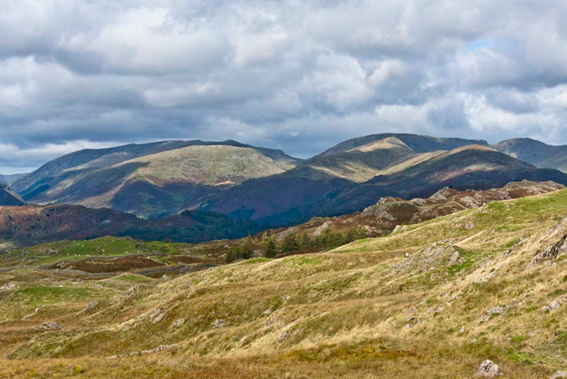
under the slopes of Black Fell, and up to a brow, where there was
a most wonderful panorama. It brought us all to a stop as we took
in the scene.
We could see - The Coniston Fells, Crinkle Crags,
Bowfell, Esk Pike, Great End, Allen Crags, Rossett Pike, Langdale
Pikes, Sergeant Man, Ullscarf, Steel Fell, Helm Crag, Seat Sandal,
Dollywagon Pike, Fairfield Horseshoe & Red Screes.
"Incredible and absolutely breathtaking", called out Little Eric.
This picture shows just part of the scene. Helvellyn with the ridge to Dollywagon Pike, and Seat
Sandal in the sun in front. Then right the highest is Fairfield with Hart Crag, while in front is Great Rigg falling to Stone Arthur. Right the ridge runs to Heron Pike. These are part of the Fairfield Horseshoe.
Allen said, "as we have said before, it just goes to show that we do not necessarily need to be high up to
get great views." Then looking left he went on, "there is a heavy rain storm
passing over Bowfell and the Crinkle Crags."
"Glad we are not over there, then",
remarked Tetley.
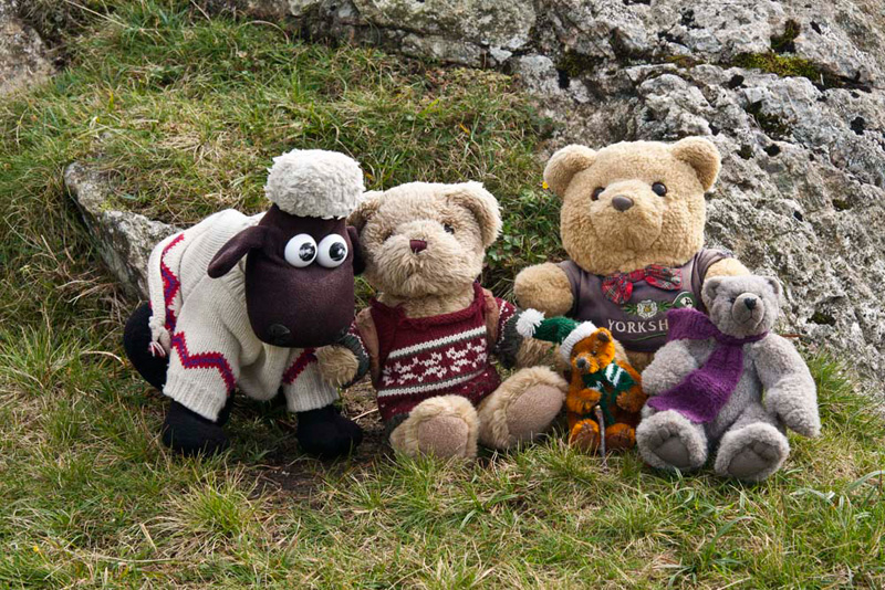
Just here there was a little
outcrop of rocks. "Perfect place to have our picture taken", said Grizzly. "We have to appear at least once in every story."
The path descended steadily,
eventually bringing us to the main A593 from Ambleside to Coniston.
"We go right", said Shaun.
This is a busy road, so Dad and Uncle Eric took extreme care at the first bend.
Past the entrance to Stephen How, Shaun said, "we soon take the
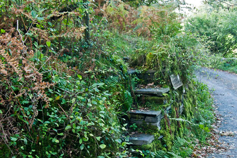
permissive path through the woods, above the road."
This brought us to a narrow lane via this flight of steps.
"Where now?", asked
Little Eric
Once again Shaun came up with the
answer, after consulting the map. "We go up the lane
until the end of the wood. There we take the narrow steep
path down through the woods, to come to the road by the Skelwith
Community Centre."
There Shaun further directed, "turn right and then left at the next junction to climb the short steep hill
to Skelwith Fold."
At the junction is was then left, rejoining the outward route, to pass Brathay Church and cross the
bridge to reach the car.
"What a lovely walk",
said Allen.
"You're right", the rest
of us chorused in unison.