SKELGILL
BANK & CATBELLS from HAWES END, &
KING'S HOW from BOWDER STONE car park
Summary
Date - 10th November 2010
Distance - 2.3 miles & 3.7
miles
Ascent - 1200ft & 1380ft
Map - OL4
Start points -
Hawes End car park (NY
247212)
Bowder Stone car park (NY 253169)
Summits Achieved
Name
Height (ft)
Height (m)
Grid Ref
Skelgill Bank
1109
338
NY 2449 2056
Catbells
1481
451
NY 2441 1986
King's How on
Grange Fell
1286
392
NY 2581 1665
Preface
"With Aunt Tish and Uncle Eddie coming
to visit on Monday, I guess that Dad will want have a rest on
Tuesday, so maybe we will be walking on Wednesday", mused
Tetley.
Noticing that Allen was sitting in front of
Dad's laptop, Grizzly called out, "what does the weather
look like for next week?"
"Just a minute while I bring up the Met
Office website", replied Allen, tapping away on the keyboard
with his paws.
"Mmm", he said. "Monday looks
to be a dreadful day with more rain and strong winds, and frankly
Tuesday is not much better." Clicking another link, he then
went on, his tone brightening, "currently Wednesday's
forecast is superb with no wind and clear blue skies all day, so
let's hope it doesn't change as the days go by."
"That is indeed if Dad plans to walk on
Wednesday", stated Shaun.
"I'll go and ask", volunteered
Tetley, as he trotted out of the room.
While he was away, Allen asked, "where
do you fancy going Shaun?"
"Well if the weather is so good then
somewhere round Keswick, as the views of the mountains will be
magnificent", he replied.
Grizzly added, "well one idea would be
to climb Catbells, so that we can bag Skelgill Bank, the one top
that Dad has done and we haven't, and so finally catch him up."
As he was speaking Tetley walked in. "You
must be psychic Grizzly as indeed we are walking on Wednesday,
and Dad's idea is to climb Catbells. Afterwards he plans to drive
round into Borrowdale, to climb King's How on Grange Fell."
Little Eric who had been quietly listening
to the conversations, now piped up, "you will all bag two
tops, but I will bag three with Catbells and tick off another
Wainwright."
"Just great", said Allen. "Now
all we have to do is keep our paws crossed that the weather
forecast stays the same."
The Walk
Part 1 - Skelgill Bank, Catbells and back
Well the weather indeed did, and in
fact Wednesday was an oasis of calm amongst days of rain and at
times stormy winds. The day was for the large part cloudless and
there was hardly any wind even on the summits.
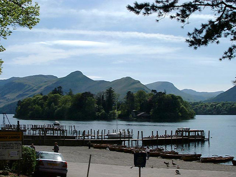
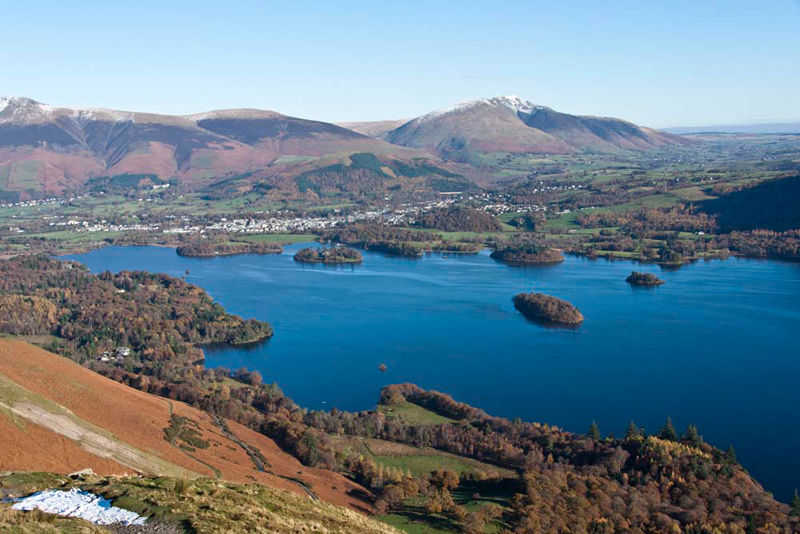
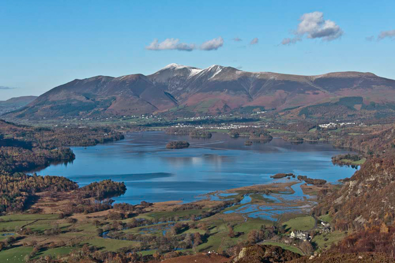
Catbells is probably one of the
most climbed fells in the northern Lake District, its distinctive
profile being instantly recognisable to many of the tourists who
visit Keswick. It is seen here from the shore of Derwent Water,
rising behind Derwent Island. What many tourists will not realise
is that there are in fact two summits. The lower rise on the
right being Skelgill Bank, rising left to the rounded dome of
Catbells.
This picture was taken in May 2002
and shows the jetties and one of the many launches that provide
what is effectively a waterbus service to a number of
destinations on the shores of Derwent Water. These are Nichol End,
Hawes End, Low Brandelhow, High Brandelhow, Lodore & Ashness.
These landings enable people to get to the more remote parts of
the lake for various leisure activities including walking, without
the need to take a car along the narrow roads, where parking can
be difficult. This is often the case for the climbing of Catbells,
where alighting at Hawes End, it is just a short walk to gain the
path that ascends the fell.
This however was not the way we
reached the start today, Dad instead driving through the village
of Portinscale and under the slopes of Swinside, to find the
small rough roadside parking area at Hawes End, just below the
cattle grid. We were the second car to arrive, followed shortly
by another car, after which the parking area was full.
"Perfect timing", said Little Eric.
Dad
chatted to the three gentlemen in this car, who told him that
they were on a walking holiday and staying at the excellent
Kirkstile Inn at Loweswater. They too were climbing Catbells, but
then going on to do the round via Maiden Moor, High Spy and Dale
Head.
Soon ready, and with us safely settled in
his rucksack, we walked round the loop in the road, to the
signpost reading 'Catbells 1 mile', Dad taking care not to slip
on the ice.
The good path climbed steadily, the magnificent
views opening out as we gained height.
"There's Skiddaw",
called out Little Eric. "We climbed it just over a year ago,
returning behind via the Skiddaw House path. Twice recently we
have walked along that path too, first when we climbed Great Calva with Uncle Eric, then Sale How and Hare
Crag on our own."
"That's right", agreed
Allen. "Skiddaw is the snowcapped mountain in the centre,
with Lower Man and Lesser Man to its right. The group to the left
are Ullock Pike, Long Side and Carl Side with the lower
summit of Dodd in front. We climbed those last May with Uncle
Eric. They were four tops I needed to bag on the way to the
completion of my Wainwright challenge."
"What's the name of the island
with the house, on Derwent Water?", asked Little Eric.
"Derwent Isle, pal",
replied Tetley. "I reckon that will be a super shot with
Blencathra in the background."
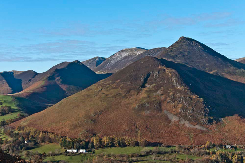
To the west, right from the start,
we had had clear views of Causey Pike with Rowling End in front,
and Dad had taken a few pictures. However we like this grouping
taken after the gradient had eased, once the initial steep ascent
had been completed.
Setting the scene, Shaun said, "Rowling End is in the foreground
rising to Causey Pike, behind which is Scar Crags then the higher
fell of Sail, with Crag Hill just peeping over its summit."
"We climbed all those in June, again in the company of Uncle Eric", said Grizzly.
Shaun then went on, "Wandope is the fell behind and to the left of Sail. The adjacent
ridge rises to Ard Crags, with Knott Rigg the lower fell at its
far end."
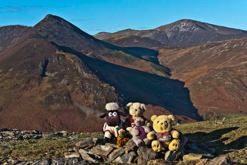
"Absolutely breathtaking", said Tetley. "It's hard to tear our eyes away Dad, but we are eager to make the short stroll on to the top of Skelgill Bank."
Although
only 1109ft in height it was very significant to us. Grizzly said, "at long last we have finally caught up with Dad on the Birkett challenge."
"I first reached this summit in October 1994, before any of
you had been adopted!", commented Dad.
As we all jumped out of the
rucksack, Shaun called out, "hurry up Dad, get the camera
out and take our picture."
Dad took the shot looking west to
capture the fantastic backdrop. Allen said, "to the left is Rowling
End rising to Causey Pike with Scar Crags beyond. To the right
the highest fell is Grisedale Pike, which was my last
Wainwright, with behind Hobcarton Head and Hopegill Head."
In front we had an equally magnificent view across Derwent Water. Tetley said, "the closest ridge is Walla Crag rising to Bleaberry Fell. Behind is Threlkeld Knotts rising to Clough Head and right the tiny pimple on the ridge is Calfhow Pike, rising to Great Dodd, and right of that Watson's Dodd."
"I know we could look at this view for a long time", said Little Eric, "but I am eager to be off
to summit Catbells and tick of
another Wainwright."
"Come on then", said
Shaun, "we had better get settled in Dad's rucksack."
The path descended at first to then
come below the nose of Catbells, where we commenced the steep ascent.
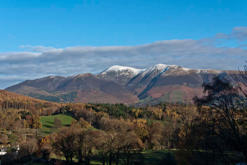
"That is a superb view of Bassenthwaite", commented Grizzly. "Barf is the fell on the left and distantly right is Binsey."
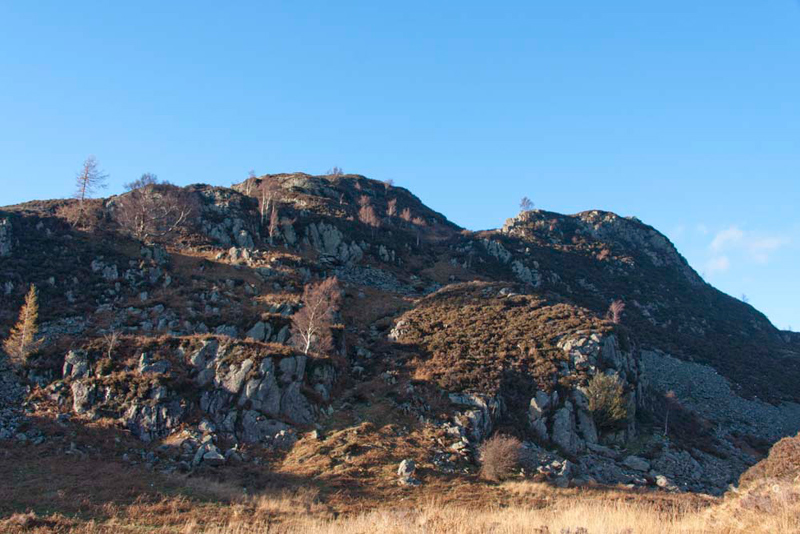
We climbed on, and about 15 minutes later arrived at the bare rocky summit.
"I guess that at one time this had
probably been grassy, but with the passage of many thousands of
feet this is all gone", mused Tetley.
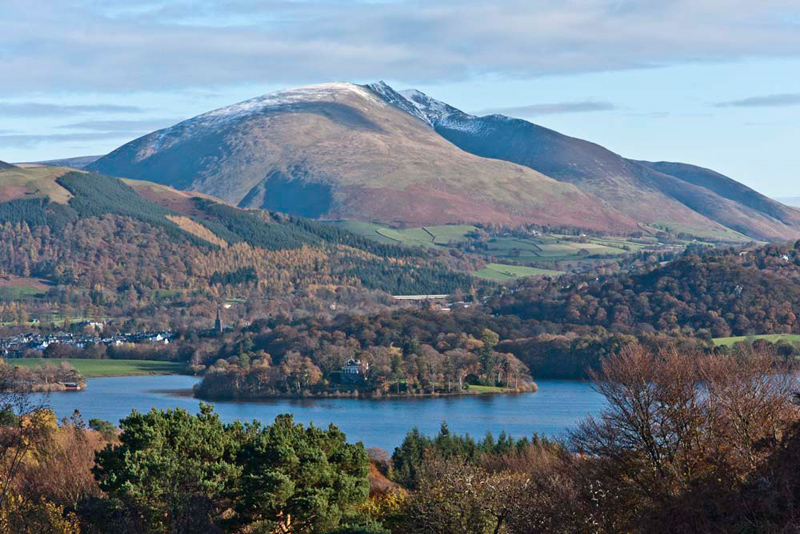
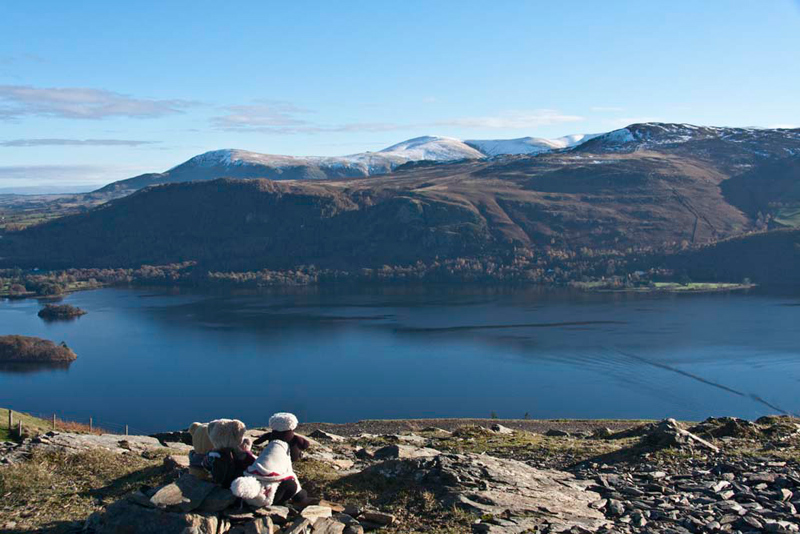
Surprisingly, we had the summit to
ourselves so we were able to sit and enjoy the views. What
captivated us the most was the quite wonderful view of
Derwent Water. Keswick is the town at the head of the lake.
Blencathra is the mountain to the right, while coming left is
Lonscale Fell, the lower hill in front being Latrigg, a very
popular climb from Keswick.
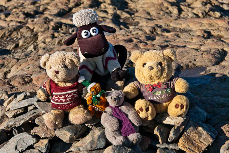
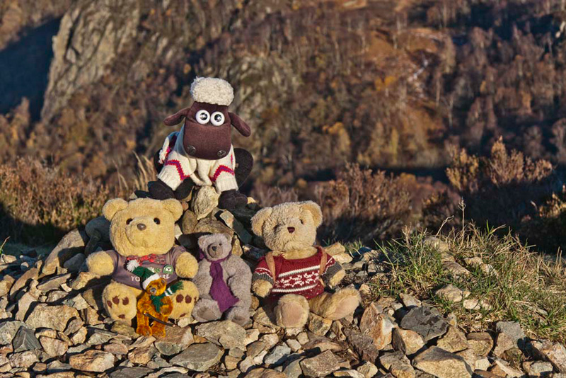
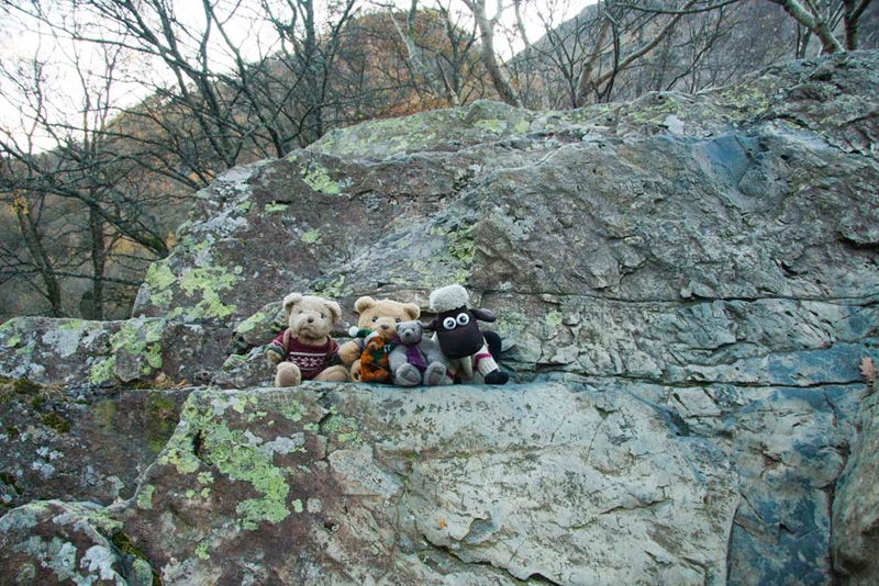
We then all companionably gathered
round Little Eric at the cairn, to record his reaching the summit.
The picture shows plainly the bare rocky top.
Shortly two young lads arrived and
Dad chatted to them a while. One was a regular walker, but the
other had not climbed a hill for about 10 years. We could see
other walkers approaching, and a large party at the col.
"That's a school group", said one of the lads.
"The peace will soon be shattered", replied Dad. "Time to set off down. We wish you well on your days on the fells."
It was to be the same route, but Shaun suggested, "by way of a variation,
from the col we can take the path descending half
right. This will bring us to the bridleway, part of the Allerdale
Ramble, that skirts Catbells' lower slopes."
At the bridleway we turned left for the easy stroll to the car.
Part 2 - King's How and the Bowder Stone
To save time, Grizzly said, "we will remain tucked in the rucksack."
Shaun then read out the walk stats for Catbells from the GPS, which Allen noted down. Then he zeroed it, ready for the next stage, before turning it off.
"We return via
Portinscale to the A66, then go through Keswick and along the
Borrowdale valley to the Bowder Stone car park", advised Shaun.
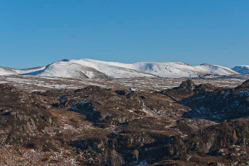
Behind this, tower the tree clad near vertical slopes and crags of King's How, at
the west end of the uplands of Grange Fell.
Here, Dad shouldering the rucksack
etc. Shaun said, "exit the car park and walk along the road in the
direction of Keswick to a signposted gate."
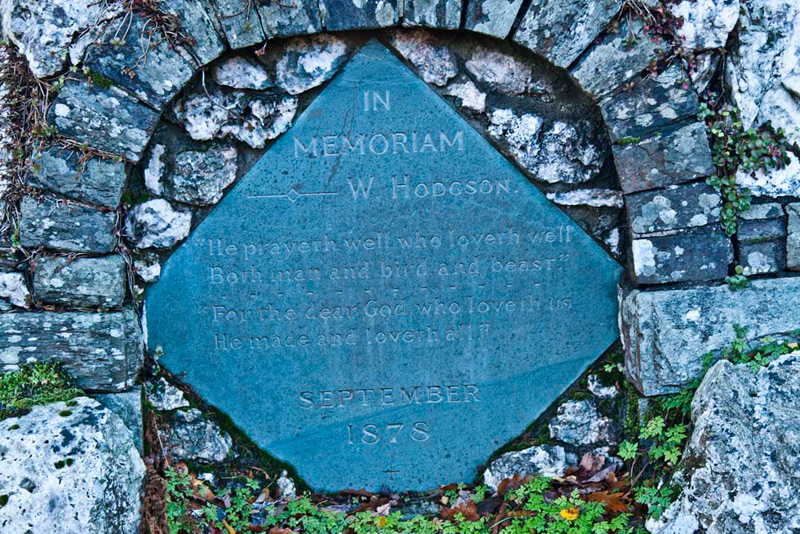
Beside this is the Hodgson memorial, passed relatively unnoticed by thousands of
people in their cars every year.
The inscription reads
-
In Memoriam
W. Hodgson
"He prayeth well who loved well
Both man and bird and beast"
--------------------------------
"For the dear God who loveth us He made and loveth all"
SEPTEMBER
1878
Grizzly said, "it is known as Hodgson's Well, the
attractive stone monument and water trough being ablaze with wild
flowers in the summer. William Hodgson is one of the Lake
District's forgotten artists. He had a great talent and was
destined to become one of the greats in that profession. In his
short life he executed many excellent works in oil and
watercolour, his most important picture being 'Daniel in the Den
of Lions'. Sadly he succumbed to a lingering disease and died at
the early age of 18. The monument was erected in his memory by
his parents."
"How sad and tragic", said Little Eric somberly.
"Which way now?", asked
Allen.
After consulting the map Shaun
replied, " we go through the gate and follow the path,
towards Long Crag, then follow it left to join the bridleway."
This we did Dad having to tread
carefully to avoid a very boggy area, after which we were soon at
the junction with the bridleway.
"Right here", called out
Shaun, as he consulted the map again.
The path climbed at first, then
came close to a wall, and dropped to a gate in it.
"Now it's through the gate and
then before we reach the next wall we need to look for a path
going off to the right", said Shaun.
After a further few hundred yards,
Allen called out, "I can see the gate in the next wall over
there, so we must be close."
"There it is just at the point
where the path bends left", called out Tetley.
The path was narrow and after
crossing a small stream, wound its way steeply up the fell. The
path had been repaired and graded into a stony staircase by the
National Trust in the past, but the wet conditions meant Dad had
to take care not to slip. The gradient never slackened until a
level area was reached by a fence.
Looking at the map, Shaun said,
"we ignore the stile in the fence, and keep on climbing up
by it."
As we climbed the path swung away
from the fence, before turning back towards it and reaching
another level area.
Tetley said, "the high ground, ahead to the right must be the top King's How, but there is no sign of a
path going in that direction."
Then Dad said, "the path swings right round that knoll, seemingly going back the way we have
come."
But, once round this, it then went left climbing over rocky
ground to circuit the higher ground to the right and then finally
wind through the heather.
Just below the highest point is the
memorial tablet, that makes sense of why the hill is called King's
How. The inscription reads -
In loving memory of
King Edward V11
Grange Fell is dedicated by his sister
Louise
as a sanctuary of rest and peace
Here may all beings
gather strength
Find in scenes of beautiful nature a cause
For gratitude and love to God giving them
Courage and vigour to carry out His will.
At the time, Princess Louise was
president of the National Trust and determined to purchase this
view point of Grange Fell, and make it, through the National
Trust a gift to the public in memory of the late King. This was
written in a letter to the West Cumberland Times of 17th August
1910, that also went on to say that there were further acres of
the fell that could be added, if a further £750 was given. This
balance was soon raised by public subscription and Grange Fell,
which included Bowderstone Cottage and the well known tourist
attraction, the Bowder Stone, became the property of the nation.
Just a few yards along the path and
climbing the remaining few feet we were at the summit. Little Eric said, "as the
second line of the verse on the memorial plaque says, this is
truly a place to find scenes of beautiful nature."
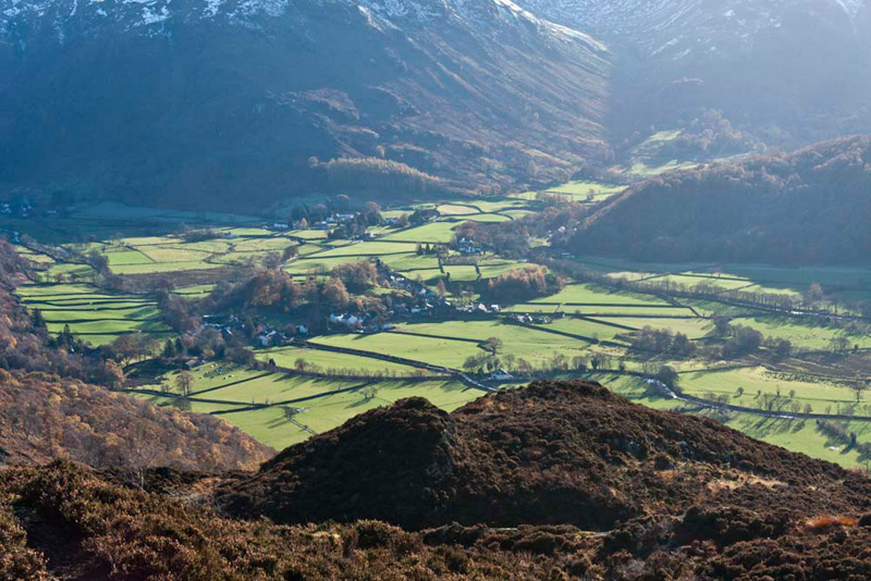
The view down
the length of Derwent Water can only be described as breathtaking,
and we stood in awed silence looking at it.
Then rather quietly, we settled to
have our picture taken. The cairn had collapsed, but the stones
were still there, so Dad built a small one for us. Shaun is
sitting on the top.
Not only did we have that wonderful
view to the north, but away to the east was a line of high
snowcapped mountains. Allen said, "that is from the left, Helvellyn Lower Man and round to Helvellyn, Nethermost Pike,
High Crag, Dollywagon Pike and to the far right part of Fairfield."
"And wow, there a beautiful view of the Borrowdale valley", pointed Grizzly.
It was with great reluctance that
we left these scenes of such splendour and took the path down
from the top. Just a few yards beyond the memorial plaque we came
to a marker cairn.
Shaun called out, "we need to
go right here, and descend to that stile in the fence then on
along the path and cross the ladderstile in the wall."
"OK", replied Dad.
The initial path was narrow steep
and rocky, so Dad took his time to ensure we got down safely.
From the stile in the fence there was a good view back to the
summit tors of King's How. The descent path starts at the lowest
point between the two tors.
Beyond the ladderstile, the clear
path continued to climb over the lower slopes of Brund Fell that
incidently is the highest point overall of Grange Fell. This was
followed by a steep descent in the direction of the village of
Rosthwaite.
"As far as I can see, when we
get down by the plantation, we need to turn right by a wall",
said Shaun looking closely at the map again.
When we reached the wall Dad said,
"there does not seem to be any path along by the wall, but
if we climb the stile over it, there is a good path going right
just a few yards beyond."
Shaun replied, " I reckon that
is the way we need to go."
So, Dad climbed the stile over the
wall and then immediately took the path right that led to a gate
in a facing wall. Through this the path descended steadily
through the lovely woodland, to finally reach the road.
"Right here", called out
Shaun, "then in a little while we go right on a path that
will be signed to the Bowder Stone."
It was not long before we were
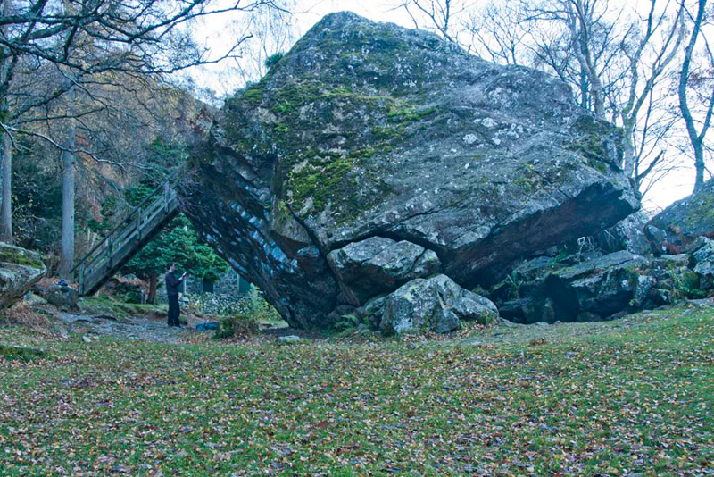
taking the turning, and soon the Bowder Stone came into view. Dad
had been here before, but not us. The stone is huge and in unison
we called out "awesome".
It is by far the biggest free-standing
lump of rock in the Lake District, measuring just about 60ft (18m)
in length and standing 27ft (8.18m) in vertical height. The
weight is thought to be about 1250 tons. There are two
possibilities as to how the stone came to be where it is. First it
could have been brought down by the ice in the Ice Age, but due
to various factors this does not seem to be likely. The second is
a rock fall, and the evidence for this is overwhelming. Not just
the Stone itself needs to be considered, but also where it lies
in relation to the form and nature of the steep slopes above it.
These slopes are surmounted by Bowder Crag, above which lies the
summit of King's How, where we had been earlier. There seems to
be little doubt that it came from Bowder Crag as the result of a
catastrophic rock failure. The fact that the rock of the Stone
and the crag are the same, adds further weight too. It has been a
tourist attraction for over 200 years and is currently in the
care of the National Trust. A building can be seen in the
background, this being Bowderstone Cottage and as late as the
1920's and 1930's still functioned as a tea room and souvenir
shop. Something Dad could have wished was still the case, as he
was gasping for a cup of tea by now!
A ladder enables visitors to
reach the top, and we could not resist scampering up, so that we
could have our picture taken.
As Dad did this a young couple
arrived with their 5 weeks old baby.
Dad called down, "I won't be long", seeing they wanted obviously to climb to the top.
On coming down, the husband looked quizzically at us, so Dad
explained, and told them about our website.
He immediately said,
"we understand."
They were from Cockermouth, and
although their house had not been flooded, nevertheless they were
affected by what happened. Many of the shops had reopened and Dad
told them that he and Uncle Brian would be visiting in December,
when staying at Armathwaite Hall.
He said, "do please come
and spend money."
"We certainly will", Dad
replied.
Then saying goodbye we headed off
along the path to the car, moving to the side to allow two
couples to pass. Just a little later we heard someone calling out.
It was the wife of the young couple, who had Dad's stick in her
hand. One of the group of two couples had spotted it, and the
young couple had realised it was Dad's.
He said, "I am always doing this." He then briefly related the other instances of losing his previous
sticks.
The husband laughed saying, "well at
least you are helping to keep the shops in business."
How right he is. We just raised our
eyes heavenwards, and remarked to ourselves, "what is he
like!!"
Allen whispered, "just wait until we tell Uncle Brian."
We all then walked back together, Dad
chatting with them. They are fell walkers too, but this had been
curtailed recently with the birth of their baby. Today was his
first walk!
So at the end of another great day,
we say thanks Dad as always.
He was in need of sustenance, so
stopped at Junction 38 services, where he had steak and ale pie,
new potatoes & vegetables, with tea. Then refreshed and
invigorated we continued south on the M6 and so home.