ELTERWATER,
SKELWITH BRIDGE, COLWITH & LITTLE LANGDALE
Summary
Date - 14th December 2010
Distance - 6.5 miles
Ascent - 800ft
Map - OL7
Start point -
NT car park,
Elterwater village (NY 329047)
Preface
"It's over two weeks since we were last
out walking", mused Tetley, who with the rest of the club
was enjoying an afternoon mug of tea and chocolate biscuit from
their 'tuck tin'.
"My, but it has been ever so cold,
especially last week when Dad and Uncle Brian, went with Fletcher
and his guests to Armathwaite Hall at Bassenthwaite", said
Grizzly.
"Fletcher told me that the Lake
District was under a blanket of snow, the mountains and trees
looking quite spectacular", said Little Eric, who was
munching away at his mint kitkat.
Allen who was sitting looking at Dad's
laptop, now piped up. "How right you are. The pictures Dad
took of the grounds at Armathwaite Hall show what a winter
wonderland it was."
So we all gathered round while Allen
navigated through them.
He then went on, "Fletcher has been
busy with Dad writing an account of the stay, and looking at
these pictures, it will make a great addition to our website.
"While you're on, have a look at the
Met Office forecast for the Lake District, for Tuesday, as that
is the day Dad has arranged to walk with Uncle Eric", said
Shaun.
"OK pal." After few clicks, Allen
went on, "the forecast is a basically dry day with sunny
intervals, little wind and less cold than last week."
"That's great, now all we have to find
out is where we are going", he replied.
"I have finished my tea, so I'll go and
ask Dad", said Tetley, "as I know that Uncle Eric was
ringing some time this afternoon, to make the arrangements."
Allen continued to browse on Dad's laptop,
while the rest of us just sat quietly finishing our tea and
biscuits.
Presently Tetley returned. "Sorry I was
so long but Dad was chatting to Uncle Eric, so I had to wait
until they had finished. It has been decided to go to the Lake
District, but not on the fells, instead we will be walking in
Great and Little Langdale, starting from Elterwater. In fact
Shaun and I have done the walk before in February 2004, but it
will great to do it again."
"Great too, for Allen, Little Eric and
I", added Grizzly, "as it will be another part of
Lakeland that we will have explored."
The Walk
Dad drove us as usual to Uncle Eric's.
"Good morning Uncle Eric", said Allen on our behalf. "Nice to see you and we are looking forward to the walk. Apart from Shaun and Tetley it will be a new area explored."
"As it will be for me", replied Uncle Eric. "And, nice to see you too Lads."
We decamped to his car for the onward journey to Elterwater
Village, that is on the approach to the Great Langdale Valley.
The snows had largely gone but there were still pockets in gullies
on the hills. On the paths, sheet ice was the hazard that we
encountered in places, so care was needed. Still cool, but not as
cold by any means as some of the days recently. No wind to speak
off, but when facing any breeze it felt cold.
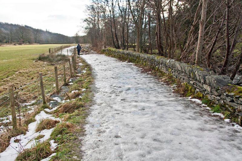
We had parked in the main car park in Elterwater. While Dad and Uncle Eric got ready, we snuggled down in Dad's rucksack.
As Dad shouldered this, Shaun issued instructions, "we take the Cumbria Way, along
side Great Langdale Beck."
"The path is ice bound", pointed Little Eric. "Thankfully there is a narrow grass verge to avoid it."
As you can see Uncle Eric had got a
little way ahead, so Shaun laughed, "you had better get your
skates on Dad, to catch up."
The path leads ultimately to
Skelwith Bridge, which was our destination. A lovely walk with
the ridge of fells to the left on which we had walked about a
month ago. After walking through open country, we entered
woodland.
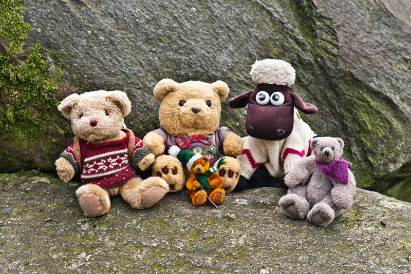
Spotting some large boulders, Allen
called out, "that will be a good place to sit for our
picture."
"OK Lads, settle down and
smile for the camera."
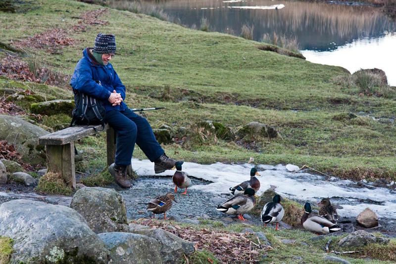
Uncle Eric had walked on and we
caught him up, just beyond the end of the woodland. He was
sitting on a seat, beside Elterwater, surrounded by ducks that
had come, hoping to be fed.
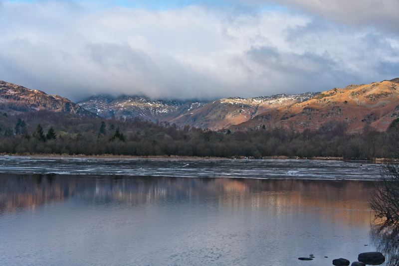
We all then sat for a while to enjoy the beautiful view across the lake. "The
Langdale Pikes are in the centre", commented Grizzly. "If only they were not covered in cloud they would have looked superb."
"Despite the cloud, it is
still a wonderful view", remarked Little Eric.
"Yes", replied Tetley,
"and when we set off we will be able to enjoy it for a while
longer as we will be looking back."
So Dad shouldered his rucksack, and
we headed on along the meandering path, eventually through a gate
into more woodland. Here the path passed above Skelwith Force.
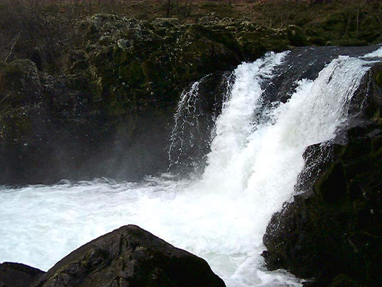
"The path and rocks that we will have to cross to view them are rather icy, so perhaps it would be best not to risk going down today", said Uncle Eric.
"I agree", replied Shaun. "We will have a picture for the story, as Dad took a shot when Tetley and I originally did
this walk in February 2004."
To avoid a particularly icy section
of path, we now walked this last part along the road, passing the
slate works and Skelwith Bridge Hotel. This stands in the corner
formed by the main Ambleside-Coniston road and the road to Great
Langdale.
"Which way now", asked
Grizzly.
"We turn right, cross the
bridge, then shortly take the second signed footpath on the right",
said Shaun, consulting the map.
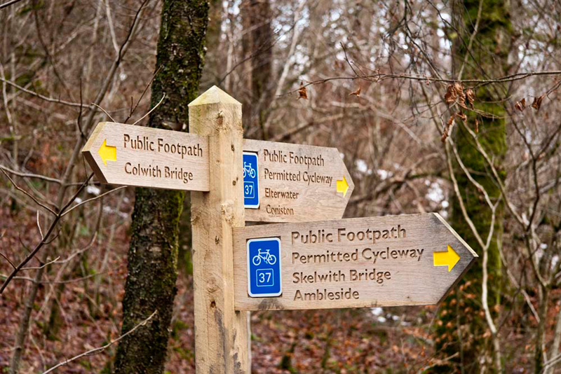
The path led through woodland
climbing steadily to a junction, with this three-armed signpost.
We all looked reading the various directions. "It
must be left here, as it says Colwith Bridge, and that is where
we are heading for", said Shaun.
Still climbing, we eventually
exited the woodland, and continued over open land to pass Tiplog
(an unusual name for a house) and Park Cottage. On along the path
we then came to Elterwater Park Country Guest House, formerly
Park Farm.
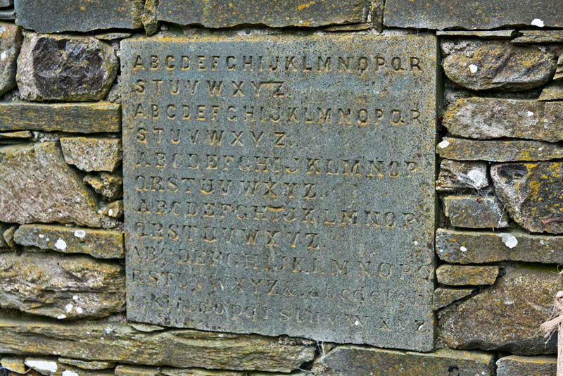
"That stone set into the wall is of interest, with the alphabet carved in 5 different
scripts", said Grizzly. "Local knowledge says it was an apprentice stone, a
teaching aid for stone masons."
"Where now"?, asked
Little Eric.
Once again Shaun consulted the map
and replied, "we ignore the access track and continue on the
footpath, as indicated by the waymark over there."
This led to Low Park, once a farm
but now a private house. This was skirted to its left along a
short stretch of track with stiles at each end.
"Perhaps a path
diversion when the property ceased to be a farm", mused Allen.
Then, we crossed
its access track and through a kissing gate continued over fields,
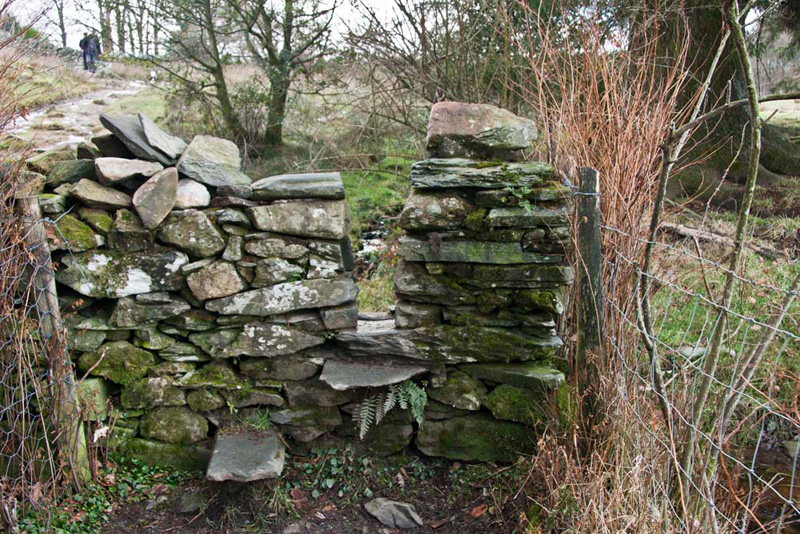
crossing more stiles, like this stepped gap stile.
Shortly after another stile was
crossed, the narrow path continued high above the Colwith Beck,
with a sheer vertical drop to the right.
"Thank goodness this section is ice free!", said Little Eric with relief in his voice.
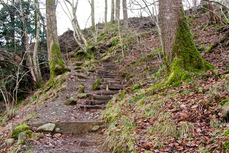
Beyond, it then descended by a series of
steps that wound down, then across level ground to a stile in the
wall to the road.
Before anyone could ask, Shaun said,
"we turn right then go left into Tongue Intake Plantation."
"Thanks pal", replied
Tetley.
This was clear to see, steps having
been built to make climbing the bank easier.
Then, beyond the fence
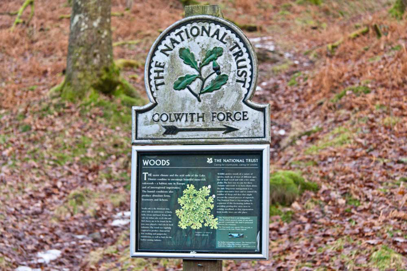
our way was clearly signed to the next objective Colwith Force.
The sign below about Woods, was
very interesting and we gathered round and took a minute or so
the read it.
It informed us that the moist
climate and acid soils of the Lake District combine to encourage
beautiful moss-rich oakwoods. A habitat that is rare in Europe
and of international importance. The humid conditions also
produce abundant ferns, liverworts and lichens. Sessile oak is
the dominant tree, often with an understorey of birch, holly,
rowan and hazel. Where the soils are richer, ash, wych elm and
bird cherry are also to be found. In the past, trees played a
vital role in local industries. The wood was regularly coppiced
to produce charcoal for iron smelting and gunpowder manufacture,
as well as bark for the leather tanning industry. Wildlife
prefers woods of a variety of species, made up of trees of
different ages, lots of dead wood and with a few sunny glades.
The best way to care for these 'Atlantic oakwoods', is to leave
them alone, apart from removing non-native trees and controlling
the number of sheep and deer that might prevent the natural
process of regrowth.
"Well", remarked Allen,
"we have learnt something today.
"Yes", agreed Tetley.
"I never realised how important the oak woodlands are."
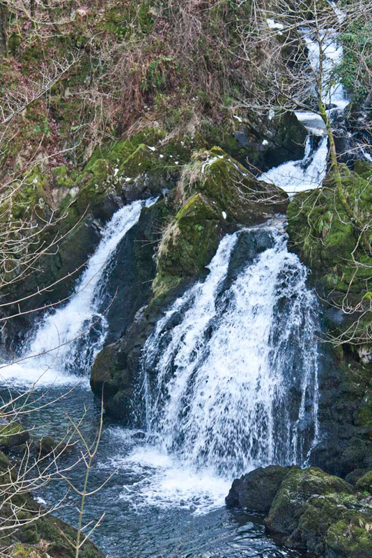
The path curved left under some
banking, and then continued up some steps. This was our route,
but first we went right on a short diversion to view the
spectacular Colwith Force, that really was in spate too!! The drop is
about 55ft.
"That's beautiful", said
Little Eric.
"It certainly is",
replied Grizzly. "I am glad that Little Eric, Allen and I
have had the opportunity to see it at last."
"And me as well", said Uncle Eric. "I have never been here before."
So, we lingered a while to take in the scene, before returning, to climb the steps, and
follow the path by the gently flowing Colwith Beck.
"It's hard to believe that in
such a short distance it will be thundering over the falls",
mused Tetley.
The path climbed on to reach a
cross track by a wall.
"It's right here, through that
gate", called out Shaun
We crossed the pasture with the
rocky height of Great How to the left, to another gate, to cross
another pasture to the buildings of High Park.
"This was a
farm", said Tetley. "However judging by the number of work mens vans that are
blocking the path between the buildings, it must be undergoing
conversion to dwellings."
"If we take the access path left to the road, and then turn right we will be on track again", advised Shaun.
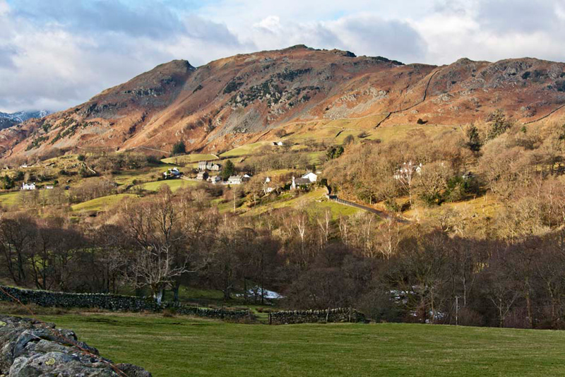
We were now in beautiful valley of
Little Langdale, divided from its larger neighbour Great Langdale,
by Lingmoor.
"What an enchanting view",
said Allen in wonder.
Strolling on, the narrow, quiet
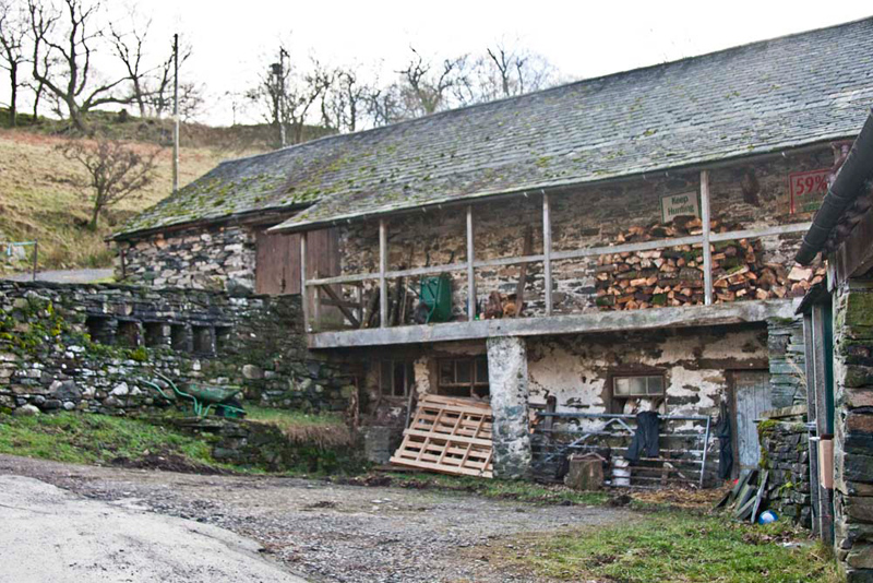
road brought us to Stang End, where, opposite the house is this typical Lake
District bank barn. Such buildings are so well represented in the
Lake District, that it can be recognised as its distinctive
building type.
A bank barn is a farm building
which combines a conventional threshing barn at an upper level
with a cowhouse, stable, cartshed or loose boxes at the lower
level. The upper level with its big barn doors is usually reached
from the fields, the lower level opening onto the farmyard. As
can be seen here, the verandah on the upper level is accessed via
a gate adjacent to the barn doors, and provides space to store
logs and small implements.
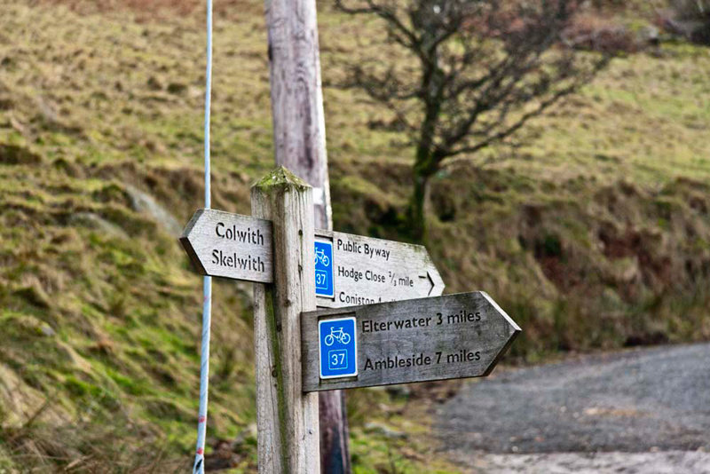
We had approached from the left
where, by the side of the road stood this three-armed signpost,
and clearly our route was right between the house and barn.
"I did not realise we still
had three miles to go", remarked Uncle Eric.
"According to the GPS, it is
only two miles", replied Dad.
Shaun said, "the distances
relate to the cycle route, which I suppose we will not be
following exactly on this walk."
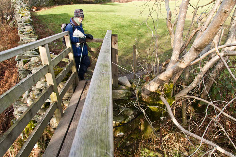
So down the left side of
the house, to pass through a gate and on along the track and cross
the footbridge over the Colwith Beck. Access to the footbridge
was protected by a gate at each end.
"That is an unusual and ingenious, gate closer", commented Uncle Eric. "A metal rope
attached to the gate, running over the adjacent tree, with
attached to it was a heavy metal weight dangling over the
water."
Crossing the field beyond, we
reached another narrow road, where we went left to Little
Langdale Cottage at Wilson Place. Built in the 16th century and
always inhabited, it now offers self catering holiday
accommodation for up to six persons.
"It is right here along the
side of the cottage", called out Shaun, who was consulting
the map.
Beyond, a path led beside fields to
a gate, and on along a walled track to a stile. The path now
immediately swung left, then right, to cross open land, to a gate
onto a cross track. The signpost indicated that going left led to
Little Langdale Tarn, but our route was right on the wide track
to a gate and beyond a fork in the track.
"Which way now"?, said
Allen.
"Left", replied Shaun.
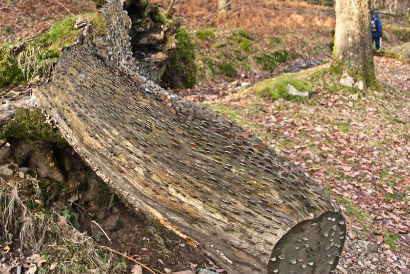
This led in to Sawrey's Wood, where
the path climbed steadily, but not before we had passed a money
tree. Money growing on trees? Well, not exactly, rather lots of 1p
& 2p coins etc, hammered into the trunk. We had seen such
trees before, around Janet's Foss near Malham in Yorkshire Dales.
Through the day there had been a
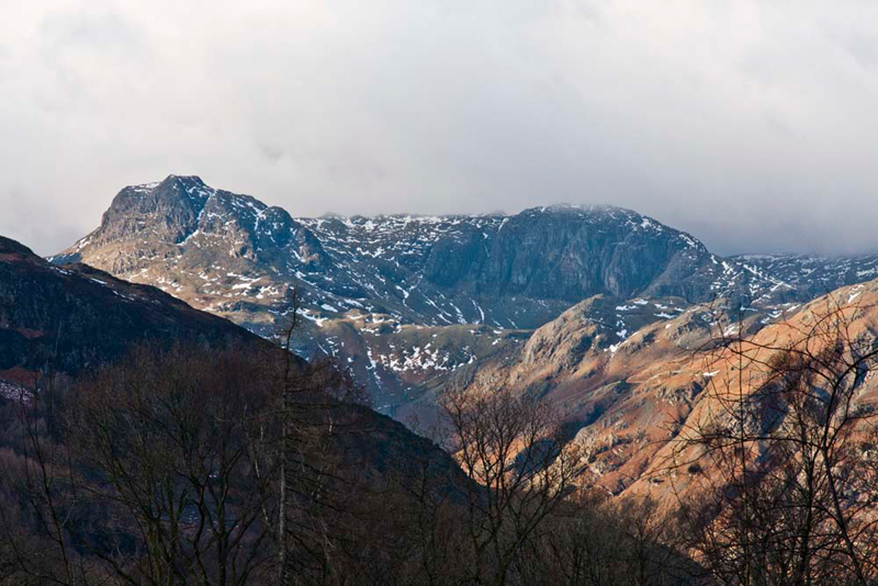
number of opportunities for views of the Langdale Pikes, but they
had been resolutely covered in cloud. However as we reach the
crest of the rise, a magnificent prospect was revealed of
Harrison Stickle (2414ft) and Pavey Ark (2288ft), clear of cloud.
"Patience rewarded at last!", cried Little Eric
Ongoing the rough path soon
descended to a narrow road, opposite a house. Immediately beyond
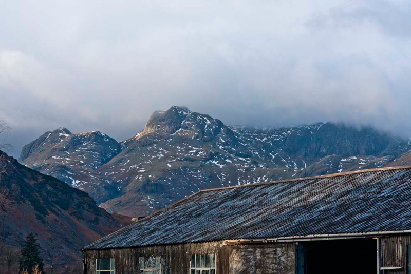
we went left off this, to walk through Elterwater Quarry. The
hole in the ground where the stone has been removed is immense,
and we could hear the slate being cut in the sheds, over which
there was another wonderful prospect of the Pikes.
Allen set the scene. "That is Loft Crag to the left, with the lower Thorn Crag to its right,
Harrison Stickle and Pavey Ark just
disappearing under cloud.
The waymarked route wound on
through spoil heaps, to come beside Great Langdale Beck and then
cross it via the bridge, to the road at Chapel Stile.
Because of
the cold weather Uncle Eric and Dad had decided not to bring a
picnic, but rather have lunch at a cafe.
Dad said, "above the Co-op store is Brambles Cafe. I went there a few weeks ago. It is only a very short distance along
the road. How about going there?"
"Fine", agreed Uncle Eric.
Dad had
delicious parsnip soup (some of the best soup he has ever had)
then a BLT on brown bread, and tea. Uncle Eric had hot chocolate,
bacon bap and then gingerbread.
"Excellent", said Uncle Eric. "I can
heartily recommend it."
We had packed a picnic, and the owners
kindly said it was alright for us to eat it in the cafe, although we did
have some of Dad's tea!
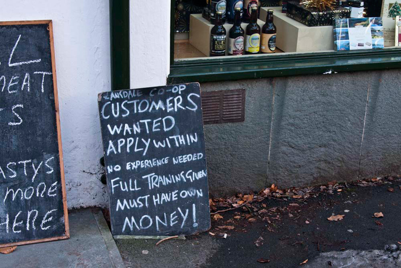
As we entered the Co-op, we had
noticed this amusing sign.
Setting off again, Shaun said, "we walk along
to recross the beck and along the path to the quarry
access road, and then follow it to Elterwater."
The initial path was very icy so Dad and Uncle Eric took great care not to slip."
"An excellent walk through lovely
scenery in this quiet corner of Lakeland", said Uncle Eric.
"Yes" agreed Grizzly, "one to recommend anyone who loves the Lake District."