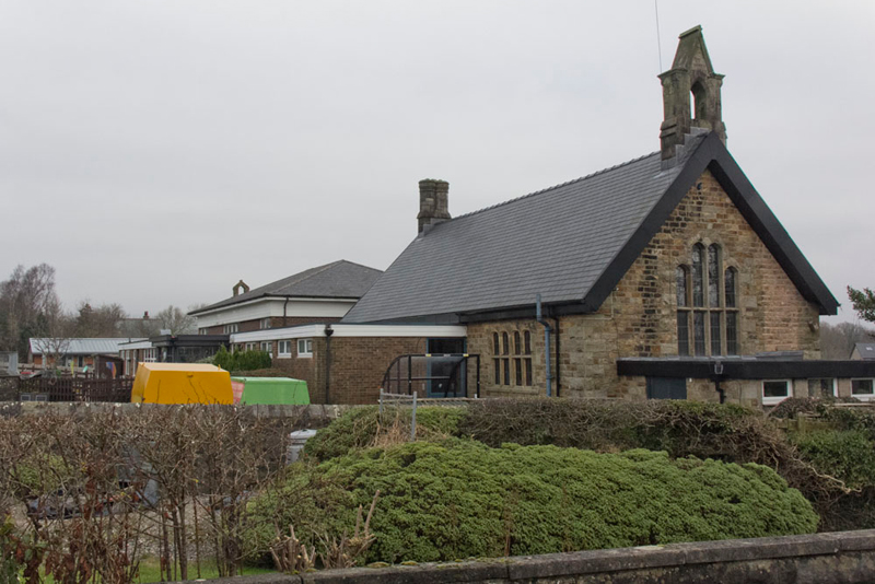
The day was overcast and rather cold but dry. There is a layby in front of the school, and this was where we parked.
Looking at the building Tetley said, I guess the stone structure at this end was the original school that has since been much extended."
Ready Shaun said, "walk back along the road and take the road alongside Ye Little Shoppe so the instructions say."
"I reckon the shop will be long gone", said Allen.
He was right, Grizzly saying, "here's the lane. I suppose perhaps the shop was once on the site of that house."
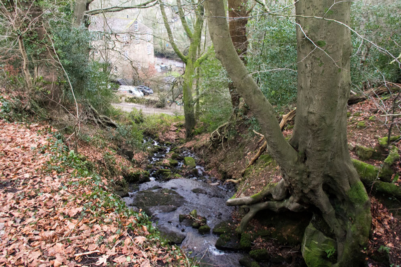
At the end Southey advised, "go left and take the descending tarmac track...
...above the ravine and stream...
...to the Wagon Road.
Facing us was the former Dolphinholme Mill, now converted to residential properties.
"I have some notes about its history. This was formerly Dolphinholme Worsted Mill. It was built in 1795 by Thomas Hinde (junior), a slave trader who had followed his father, Thomas Hinde (senior), into that business before establishing the mill. Samuel Clegg installed gas lighting in the mill in 1811. The remains of this are considered the oldest remnants of a water-filled gas holder tank. The gasworks also lit the mill owners house and the village street. Through gas illumination the mill owners could save the expense of 1500 candles per night. The mill and adjoining gasworks operated until 1867."
"I suppose the houses were once occupied by workers at the mill", pointed Tetley.
"Continue along the street crossing the River Wyre, then soon at a corner take the rising track right", stated Shaun.
This shortly led to this tiny bridge and stile into a field.
Calling out, Grizzly said, "there is the remains of Dolphinholme Gasworks chimney that was built with two flues.
"Across the field to come to the field boundaries that form an inverted V-shape."
Reaching the fence, Little Eric looking confused said, "I don't see the V."
Shaun and Southey studied the map and after a bit of muttering Shaun said, "since the walk was published the field has been subdivided by this fence. Go through the gate and head on a little left."
The gate was padlocked as it had only one hinge. No problem to our Dad who was soon nimbly on the other side.
"Not surprising the instructions are out day bearing in mind it was published 40 years ago", remarked Allen.
Soon Tetley called out, "there's the V-shape and the narrow ongoing path.
The conifers overhung the path in places brushing against us as we strode on. The path brought is to a plank bridge and stile on left out into a field.
Southey instructed, "head towards the farm and over the plank bridge onto the Wagon Road."
Shaun advised, "cross the road, over the stile, and then walk by the tall boundary wall of the farm and then the hedge to the bottom corner and over the stile...
... then right and in a few yards over another onto Tinkers Lane, where turn left."
Striding out, Dad's progress was stopped by Grizzly suggesting taking this tree. "It would have looked better if the sky had been blue", he commented.
Southey said, "according to the instructions soon after passing a house on the left the road crosses Street Brook by a bridge being identified by two white railings on either side."
Seeing it Tetley remarked, "it looks to be many years since the railings saw a lick of paint."
Dad advanced a few steps then Shaun pointed, "take that signed path into the trees that will shortly lead to a bridge and stile."
"Eww", said Little Eric. "That looks to be very boggy, and it is not clear exactly where the path is."
Dad picked his way carefully, his boots sinking into the ground, soon saying, "it now goes a little left to that gate below the power lines."
We were heading to Stonehead Farm, seen in front.
Following the power lines Dad made his way over the boggy field and to the farmyard, where he was met by the lady farmer who asked, "have you seen a black labrador."
"No sadly not."
She replied, "I'll have a drive around to see if I can him it."
Walking through the yard to gate and on out to the road, suddenly the dog ran across the road and Dad fussed it briefly until the farmer called it back. "He got locked in a car!", she told us.
Opposite Stonehead Farm...
... a stile led to a narrow path that was initially blocked by gorse making the progress prickly...
...that dropped down to this footbridge...
...over pretty Street Brook.
"Go left by the stream", advised Shaun.
This brought us by a fence that we followed to a gate and down to the ford.
Looking ahead, Tetley said, we've been along here before and past that large and beautiful house called Lane Head and in fact the rest of the walk will be a repeat."
"Never mind", said Little Eric. "It is a long time since we were along here."
Last time we walked through the grounds, and indeed that is still the case, but there is a sign requesting walkers take the diverted route to the left."
"We'll to that", said Tetley emphatically.
As we rejoined the access, Grizzly said, "We've not had our picture taken yet. Let's sit on the wall."
Comfortable again in the rucksack Shaun issued instructions. "Walk Lane Head's access to the road where turn left, but soon fork right."
The property Bracken Lee was hidden from us on the left. "Look" called out Little Eric. "The postman deliverers their mail to that personal post box. I know it is not an active one but will you please take a picture for my collection anyway?"
"Sure lad"
The lane brought us to the crossroads at Street. "We've been here many times on our way doing the Bowland Fells all those years ago", said Tetley.
"10 years this year", replied Southey. "My how time flies. It was a particularly important time for me. as I with the rest of you completed the challenge."
Walking ahead we soon came to Street Bridge.
Grizzly told us, "it is a Grade II listed structure. It dates from 1835 spanning the River Wyre. The official entry goes on 'punched sandstone blocks with chamfered rustication. Single elliptical arch with keystone. Band below solid parapet with coping'."
"We can see the inscribed stone above the keystone", said Tetley. "I recall in reads 'JT 1835'."
As Grizzly had stated it spans the River Wyre seen here looking up stream.
"We take the stile on the right to join the Wyre Way for our return route", advised Southey.
For the first part the path kept by the river and crossed the access to Wyreside Hall, where this graceful bridge spans the river.
Once again Grizzly produced some notes. "This too is a Grade II listed structure. It dates from the early 19th century. The official listing reads 'punched sandstone blocks with rusticated voussoirs. Single elliptical arch flanked by attached piers with round-headed niches. String course under solid parapet originally having two openings on each side with baluster infill. Western opening on the south side now filled in. Western opening on north side lacks 2 balusters'."
"Thank you pal. We learn so much from your research", praised Tetley.
Dad took a shot of Wyreside Hall. Rather obscured by trees, we still thought it was worth including.
I can further educate you pals about it. "The date and builder of the original Wyreside Hall is unknown. There was certainly a building present when the estate was purchased by the Cawthorne family in the late 18th century. John Fenton Cawthorne (1783-1831) commissioned Robert Adam in 1790 to remodel the old house. Cawthorne died childless and in 1836 Robert Garnett bought the house and in 1843-4 he commissioned Lancaster architect, Edmund Sharpe, to remodel the house. There were later 19th and 20th century additions and alteration. It is now a hotel."
Strolling Allen called out, "I know I do not like sheep pictures, but look at that one standing looking out from the alcove. Very sensible keeping out of the cold air,"
Shortly then we came to the lovely house at Coreless Mill. We saw the owner who said it was ok for Dad to take a picture. Dad had a chat about a few other things too.
The old millstones can be seen against the wall.
"There's the old mill wheel preserved for posterity", called out Little Eric.
In the picture of the house the gate to the right was the continuing route of the Wyre Way crossing a field and then along a narrow surfaced walled path.
"We need to look out for a path branching left off the Wyre Way" advised Southey.
"Here it is" called out Tetley.
It was steep and muddy leading into a field and so to at lane at Dolphinholme. "Can we visit the church?", asked Grizzly.
"Sure lad."
"This is St Mark's Church, built between 1897 and 1898 to a design by the Lancaster architects Austin & Paley", said Grizzly. "It is a Grade II listed building. It was built to replace an older church erected some 60 years earlier for the use of mill workers."
Going inside here is the view along the nave.
"Grizzly went on, "the three bay arcade to the north aisle is carried on octagonal piers."
Walking down into the chancel we viewed the altar adorned with its beautiful covering.
"I recall that the cloths on the altar changed according to the different times in the Liturgical year" said Dad. "So this represents Epiphany."
Returning, Grizzly pointed to the font. "The cover is dated 1910."
"The roof of the nave is impressive", commented Tetley.
"I presume that statue depicts St Mark", pointed Allen.
"Thank you Dad", said Grizzly as we left and walked to the road and car.
What a lovely walk", said Southey.
"Yes even though we had actually already done the last section from Lane Head before, there was some new ground", went on Tetley.
On the way to the start we had passed the Fleece Inn. Little Eric said, "I noted that there was a post box set in the wall. Would you mind stopping to take a picture please?"
"No lad. Of course I'll get a picture."
Well Dad decided to go the whole hog. First here is the Fleece Inn...
...its appropriate sign...
...and as Little Eric had asked, the post box dating from the reign of King George VI.
Dad said, "I understand that it has a good reputation for food etc."
"From the number of cars I think you are right", agreed Allen.
So very happy after our adventure, we went on home.
back