GREAT
KNOUTBERRY HILL & WOLD FELL from DENT STATION
Summary
Date - 30th December 2007
Distance - 8.25 miles
Map - OL2
Start point - Dent station (SD
764875)
Summits Achieved
Name
Height (ft)
Height (m)
Grid Ref
Great Knoutberry Hill
2206
672
SD 7885 8715
Wold Fell
1831
558
SD 7927 8513
Preface
For once we did not have to get up
quite so early but nevertheless it was still dark when we set
off. For the majority of the Yorkshire Dales walks Dad uses the
road from Ingleton to Hawes to get to the start and this walk was
no exception. However once we had passed Ribblehead with its
imposing viaduct we soon turned off on a road we had never been
along before. It was narrow and ran high along the side of the
hill before descending to pass under the huge Dent Head viaduct
and on past isolated dwellings. At one point we had to cross a
bridge that was so narrow the wing mirrors on the car nearly
scraped the walls. We breathed a sigh of relief once over!
Finally we turned up another narrow lane and climbed steeply to
reach Dent station. This and the viaducts are on the railway
known as the "Settle to Carlisle".
Over 70 miles long this runs
through the hills on the backbone of England. 19 huge viaducts
(Ribblehead being the largest at 440 yards and 165 feet at its
highest) were needed to cross the valleys and rivers. 13 tunnels
(the longest and deepest being Blea Moor - 2629 yards long and
500 ft deep) had to be cut through the hills. The line was built
between 1869 and 1875 - a testament to the determination of our
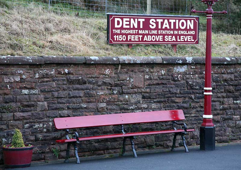
Victorian ancestors. Dent is the highest station and indeed, as
this sign professes, the highest in all of England.
Photo
courtesy Bob Woolley (Uncle Bob)
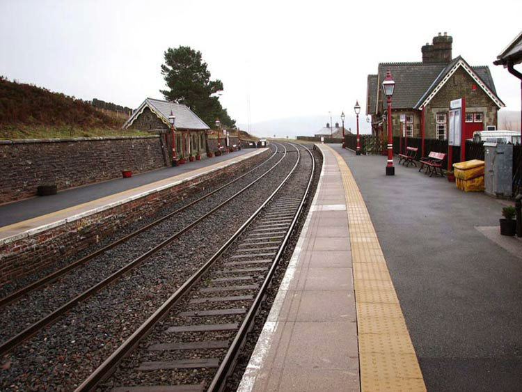
And here is a view of the station.
If you look carefully you will
notice behind the building on the left a black barrier. This is
the snow fence that was intended to stop the snow drifting off
the fields on to the line. It is in a rather dilapidated
condition now, as winters are much milder with little snow. In
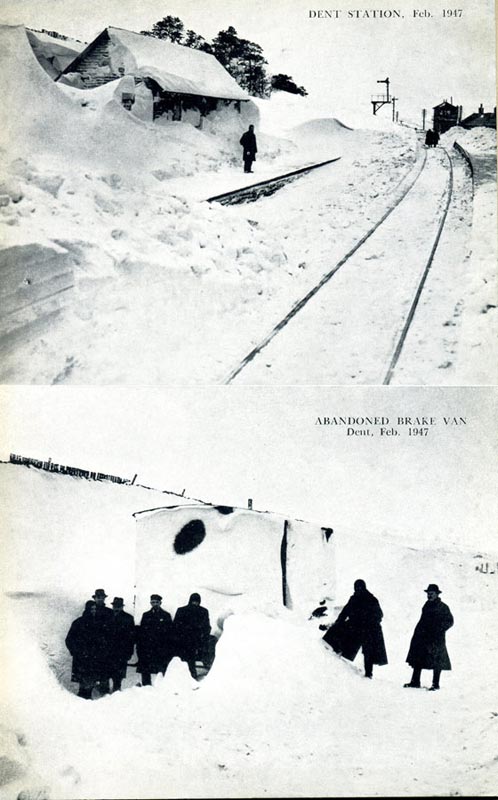
the past using snow ploughs the line was mostly kept open. In 1947
however such was the snow that these resources were tested to
their limit. One snow plough train was derailed trying to clear
the 20 feet of packed snow in ice-hardened layers and despite all
efforts the line was closed for two months. Our Dad had just
obtained a copy of a book published in 1948 detailing the history
of this line and from this here is a similar picture to the above
showing the conditions at that time. The snow fences can just be
seen too.
Much more information is available
a www.settle-carlisle.co.uk, but now we had better get on with telling
you about the walk proper.
The Walk
It was a misty morning as we hopped
into Dad's rucksack and set off crossing the railway and walking
steadily uphill on the road called the Coal Road. In the 18th
& 19th century coal was mined nearby and carried out on this
road hence its name. It reaches its summit at 1750ft but
thankfully we turned off somewhat lower down on to a bridleway.
After another half a mile we arrived at a gate on the left where
a clear sign pointed up the hill by a fence that disappeared into
the mist. It was rather boggy on the ascent - so were glad to be in
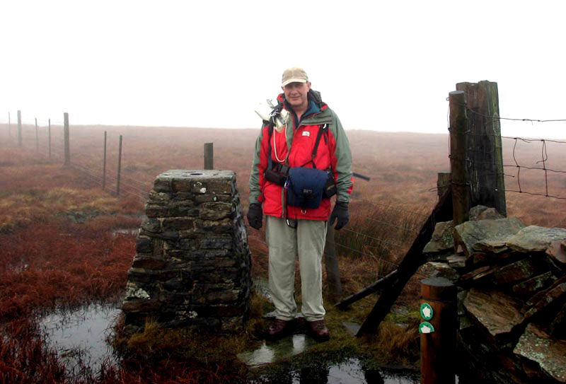
the rucksack! Finally we crested a rise and the trig point
marking the summit of Great Knoutberry Hill was reached. Here is
Uncle Bob posing at the summit.
As you can see this is
surrounded by a moat, so we were glad that Dad was careful not to
drop us when he took us to have our photo taken. But, as he sat
us down we realised that the top was wet, so we had some rather
damp bottoms as a result.
"You might have
sat us on your map case!", complained Allen.
A long descent then followed. Ahead
of us was the bulk of Wold Fell, which was our next objective.
Once a track was reached we followed a wall up this fell to its
wide flat top. To reach the spot height position marked on the
map by the Ordnance Survey we had to cross the wall and walk a
few hundred yards on level ground. There was not a way through
the wall and to climb it would have been dangerous so Dad took
our photo by the wall to mark that Wold Fell had been climbed.
After a stop so that Uncle Bob and
Dad could have a sandwich etc, we all then retraced the ascent to
the track, which if followed would have taken us to Arten Gill.
Our route was to join the other end of the bridleway that we had
been on after leaving the Coal Road. We joined this and followed
it all the way to its end and then down the road to the station.
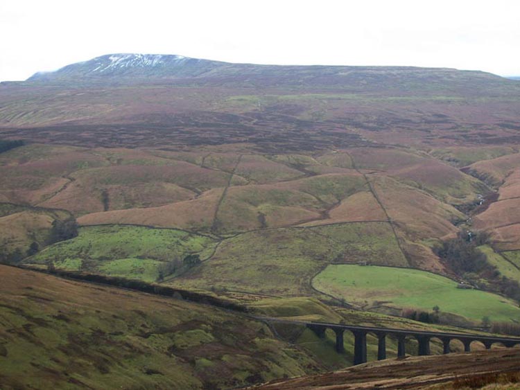
As we walked we could see a partial view of the impressive Arten
Gill Viaduct backed by the hill Whernside.
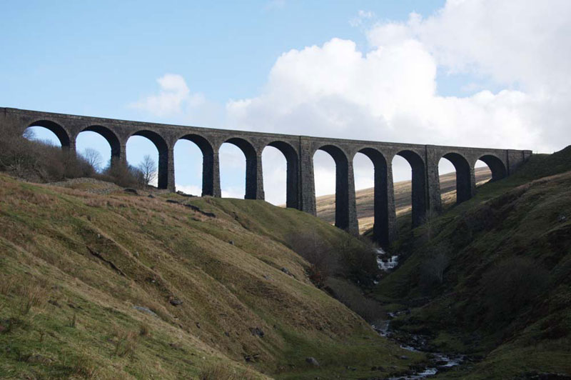
If we had descended the track down
Arten Gill, then Dad would have been able to take this
photograph, as he did on a walk a few years later with Uncle
Eric.
Some food and a warming drink
beckoned Uncle Bob and Dad so once we were settled in the car
they drove to the village of Horton in Ribblesdale that stands in
the shadow of the hill Pen-y-Ghent. At the namesake cafe, they
enjoyed a pint mug of tea and sausage sandwich. We had our own
picnic in the car.
Now there is a story we must relate
concerning Dent Station, told to us by Uncle Eric who is very
interested in railways –
The village of Dent from which the
station takes its name is some miles away down the dale. A
tourist enquired of a local resident why the station was so far
from the village. After a moments thought the local replied
"Well lad, happen they wanted it by the railway line".