STAINTON
PIKE & THE KNOTT from the CORNEY FELL ROAD
Shaun, Tetley, Allen, Grizzly, and
Dad too of course, complete the named Wainwright Outlying Fells
Summary
Date - 10th December 2009
Distance - 7.5 miles Ascent
- 1350ft
Map - OL6
Start point -
Gateway foot Corney
Fell road (SD 115945)
Summits Achieved
Name
Height (ft)
Height (m)
Grid Ref
Stainton Pike
1632
498
SD 1526 9426
The Knott
1086
383
SD 1431 9517
Preface
Allen, Grizzly and Tetley were
sitting chatting, while munching away on a bar of Kendal Mint
Cake, they were sharing.
"It's a nice tradition of
Uncle Eric's and Dad to eat a square of Kendal Mint Cake, to mark
the achievement of climbing each Wainwright fell", remarked
Grizzly.
"That's right", Tetley
replied, "but there has not been much scope for hill
climbing with all the rain and wind over the past few weeks."
"Looks like it is going to be
dry tomorrow, and Dad and Uncle Eric have it down as a walk day,
so hopefully we may get up on the hills", chimed in Allen.
"Spot on", said Shaun,
who had trotted in with Little Eric on his back, as Allen was
speaking. "We had better have an early night too, as it is a
long drive to the start", he continued.
"Where are we going",
asked Tetley, with anticipation.
"To climb Stainton Pike",
he replied.
"Magic!", shouted Allen doing
somersaults round the room. "This means we will complete the
challenge of climbing all the Wainwright Outlying Fells."
"I wasn't sure we would get
there this year, bearing in mind the distance and the short days",
said Grizzly.
"I'm just so happy for you all",
said Little Eric, who having joined much later would alone not
complete them.
"Thank you pal", replied Shaun. "But you never know as time goes by you may get to complete the challenge. Uncle Eric still has quite a few to tick off, and I am sure Dad will accompany him, and this will advance your progress too."
The Walk
Before we commence our account of
the day we should mention that we attempted to climb Stainton
Pike in January 2009. Due to the severe weather conditions in the
early part of the day we only summited The Knott. It is
this circumstance that has set up Stainton Pike to be ours
and Dad's last Outlying Fell.
An early start was the order of the
day, so that we could get to Uncle Eric's by 08.30. Here we
decamped to Uncle Eric's car, as he had kindly agreed to drive.
The route was a familiar one. First along the A590 Barrow road,
passing beneath the huge mass of Whitbarrow Scar.
"That was one of the catch-ups,
I had to do, to be able to complete today", piped up Allen.
"Seventeen in all between you
and I", replied Grizzly. "Dad is really so good to us."
At Greenodd, we went right onto the A595, through Foxfield and by-passing Broughton in Furness.
"We've been to Broughton a few times, after walks, for Dad to make a tea stop at the Square Cafe", commented Allen.
Dropping down we arrived at Duddon
Bridge, which we crossed, then soon, where the road turned sharp
left, Uncle Eric kept ahead up the Corney Fell Road. This is a narrow road
with passing places that winds its way up, reaching about 1250ft
at its summit.
"We parked here in October 2007, when we climbed Kinmont Buck Barrow, Whitfell and other tops", said Tetley. "In fact
we did seven in all that day. Some were Outlyers, so contributed
to our being in this position today."
The cloud was down here, but
Grizzly recalled, "it was clear that day."
Continuing, the road descended to eventually rejoin the A595.
Just before at Millgate, Uncle Eric parked off the road by a convenient
gateway.
We were eager to be off so jumped
into Dad's rucksack, and settled ourselves.
"You've got our picnic?",
asked Tetley.
"Of course. It's safely tucked
in my rucksack", replied Allen.
"Let's hope we don't need your
rope, today, to scale the cairn, like we did on Harrop Pike",
remarked Shaun.
After all this banter, Uncle Eric
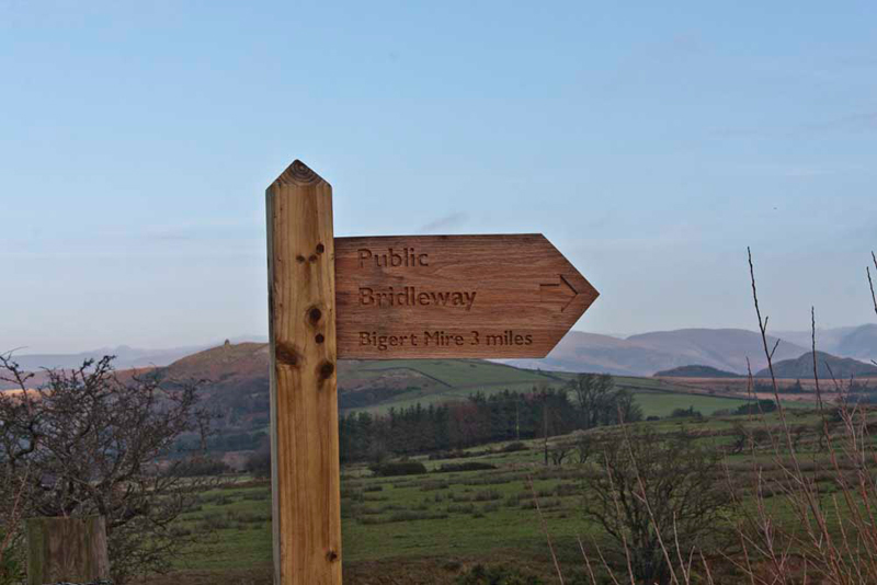
and Dad were now ready. Shaun instructed, "we walk back up the road to take the track left called Fell Lane that provides access to Grange Farm."
Initially the gradient was steep, but then it eased and soon Little Eric called out, "here's the signpost for the track."
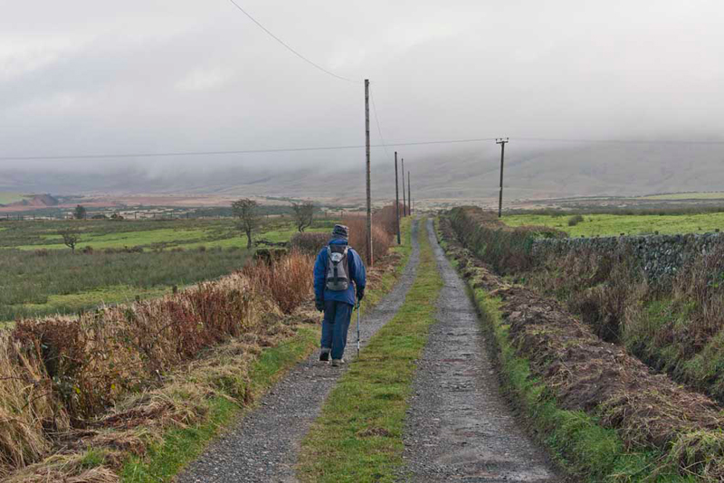
Here Uncle Eric
strides out along it. You can see that the cloud was down,
obscuring our objective ahead to the left, but we are pleased to
say that it soon lifted, leaving sunny periods and clear views.
It was a pleasure too, that there was no wind whatsoever, even on
the summits.
At the end of the straight stretch, the track bent sharply left to the farm. "We follow the bridleway through the gate ahead", advised Shaun.
Here the terrain changed
dramatically to a very wet and muddy path. "Hardly surprising, as it does not serve any properties", said Tetley.
The path was
indistinct in places, and much of the walk was now over wet ground,
exacerbated by the recent heavy rains. As we walked on, the
clouds lifted, Allen calling out, "there's Stainton Pike. We can see the summit cairn too."
Being rather indistinct, the
meandering path was at times hard to follow, so we were quite
relieved to reached the prehistoric circular enclosure
raised on a slight bank. "Good", said Shaun, "this means we are on the correct route."
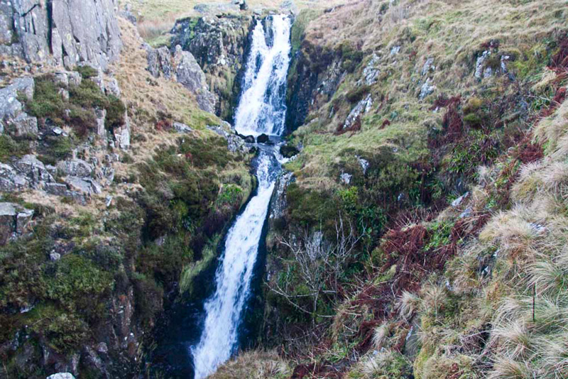
Looking distantly ahead, Allen said, "that is the ravine
of Rowantree Force. Wainwright extols its virtue,
saying a visit is the highlight of the ascent."
"The official bridleway crosses the beck here, but to get to the waterfall we just keep ahead and ascend the south rim of the ravine", stated Shaun.
It was a steep
climb, but there, Uncle Eric said, "it was worth the effort", as we viewed the impressive double
drop waterfall. It poses perfectly for the camera.
Having also gained height on our ascent, further progress necessitated crossing the gill. "Best to climb on by it for now", said Uncle Eric
The gill was swollen after the rains, but quite soon we found a place to cross. "Over the fence now", said Shaun, "and traverse the rough undulating
ground to the summit."
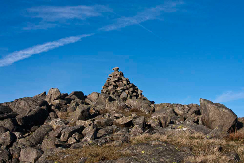
After a while Tetley called out, "we are nearly there, the cairn is just ahead.
Dad had arrived before Uncle Eric,
so we all waited patiently for him to catch up, so we could
all reach the cairn together. And that was it, all the 103
Wainwright Outlying Fells climbed!
"Yippee", shouted Allen,
"Hooray", the rest of us
cried out in unison.
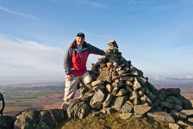
Uncle Eric congratulated us,
shaking Dad's hand and our paws.
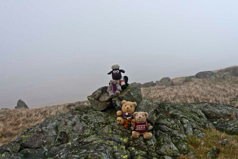
We had scrambled on to the cairn,
and Uncle Eric kindly took our picture with Dad for the record.
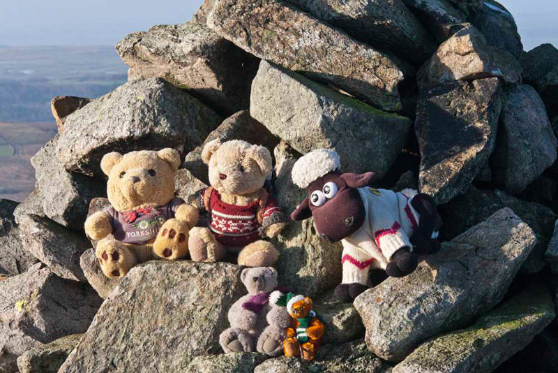
Then Dad took just us in close-up.
The view from here has a wide
prospect of higher fells, Great Gable etc., but they were
too far away for a picture.
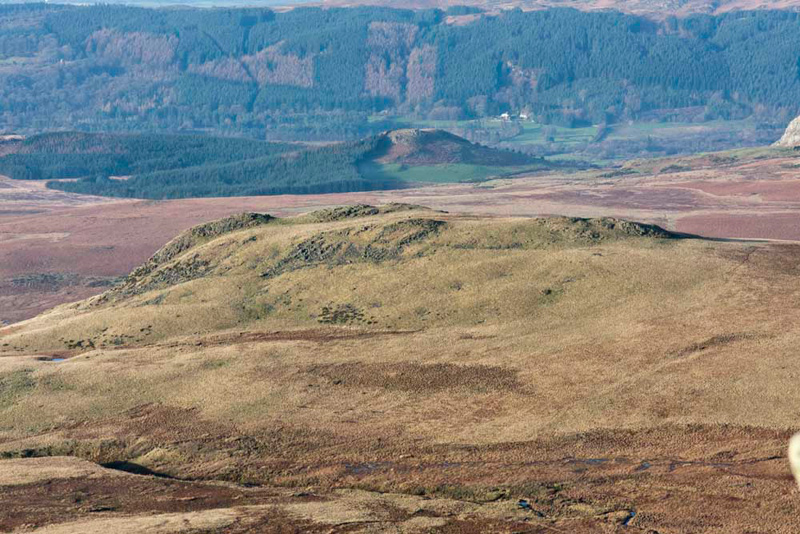
However, below was The Knott, our next
objective. "We can see clearly the lying water in the boggy area,
where we attempted to cross from The Knott, in January, and see why we had to abort", said Tetley.
"I doubt it is
ever dry", remarked Dad.
Before heading for this Uncle Eric said, "time for lunch."
"Oh yes", agreed Allen.
As there was no wind we were able
to sit by the cairn and enjoy the views. Uncle Eric commented, "amazing for December, when this has been impossible on
many days in the summer."
Grizzly told us about the origin of the name. Stainton means 'stone settlement' from Old English stan and/or Old Norse steinn 'stone'. plus tun 'village, settlement, farmstead'."
Ready again, Shaun said, "the extremely boggy area has to be
avoided at all cost, so we should cross right to the fence and make
our steep descent alongside, climbing over at a convenient point. Then where the fence turns left, keep ahead under
the slopes of Yoadcastle."
After a while a narrow trod
materialised, which we followed. At a point roughly due east of
The Knott, a trod branched off left that led straight to the
summit. Time was getting on and some mist had come down, so
we did not linger any longer than it took for Dad to take our
picture.
Allen said, "it is hard to believe what horrendous conditions we had to contend with here last time. A torrential rain storm that lasted nearly an hour. We were fortunate to be deeply tucked inside the rucksack. All you could do Dad was hunker down by the cairn and ride it out. We really felt for you."
"Aye a day I will remember forever", replied Dad. "Later that day we climbed Muncaster Fell, the weather then glorious sunshine. I had dried out by them too."
Dad pointed, "that's the gate we are aiming for Eric."
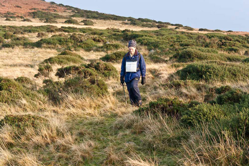
So off we went descending steeply and then on through the gorse on the lower slopes. Here Uncle Eric makes his descent.
This then left about 400 yards over
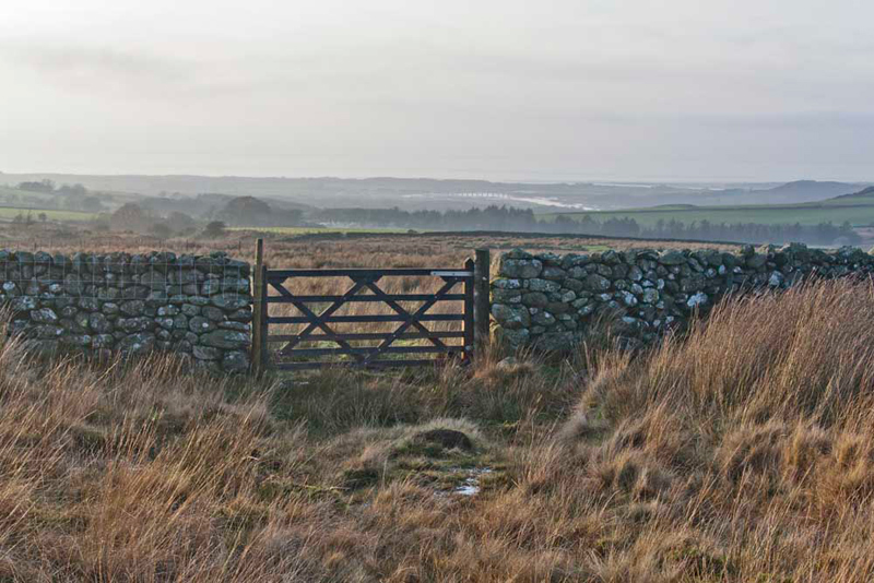
trackless rough tussocky grass and bog! A very wet crossing, Dad and Uncle Eric paddling through as best they could. "I am not sorry to get to the gate", commented Uncle Eric.
Beyond the gate, a further short
section over rough grass brought us to the muddy track
beside Stainton Beck.
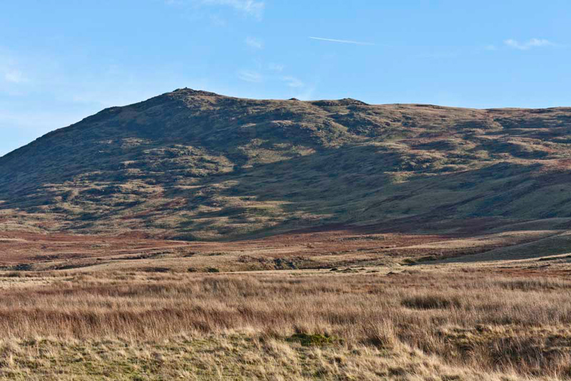
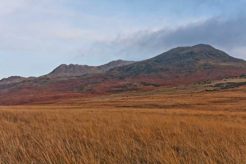
Little Eric said, "that will make a nice shot looking back. The Knott with White Pike behind."
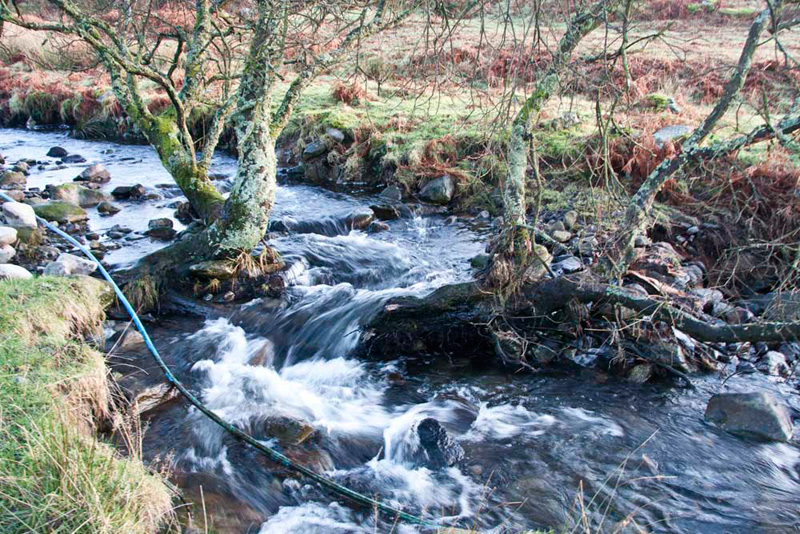
We had Stainton Beck for company all along, seen here hurrying over a tree that has
grown out over the water.
The track led through the yard of
Stainton Farm, to follow the winding access
to Broad Oak and the main road.
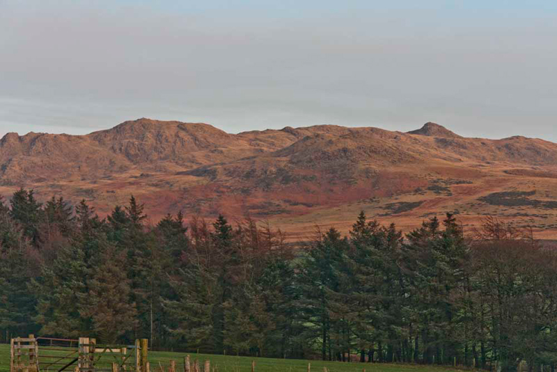
Suddenly Shaun called out, "Uncle
Eric, Dad, just look at the fells bathed in the setting sun. It
will make a nice picture."
Dad immediately got his camera out
and snapped it. Just as well, as only minutes later the effect
was gone, as the sun sank lower.
"The Knott is in the centre
foreground, with White Pike behind to its left and Yoadcastle to
the right", said Allen.
At the main road it was just a
short walk uphill to the car.
"A super day", cheered Tetley. "And a major challenge completed."
"Yes, a cause for celebration", agreed Grizzly.
Heading home, it was a very satisfied feeling we had, to have completed the challenge of
the Wainwright Outlying Fells. They range in height from the very modest 172ft
of Humphrey Head to 2037ft of Walna Scar. Not pushovers by any
means as many involve crossing rough and at times trackless
terrain to reach their summits. This is particularly so for those
from Birker Fell Road, Corney Fell Road and the Shap Fells west
of the A6 road.