BOWDERDALE, THE
CALF, HAZELGILL KNOTT & WEST FELL
from BROW FOOT
Summary
Date - 5th August 2008
Distance - 11.5 miles
Map - OL19
Start point - Brow Foot (NY 683049)
Summits Achieved
Name
Height (ft)
Height (m)
Grid Ref
The Calf
2215
676
SD 6673 9705
Hazelgill Knott
1896
578
SD 6727 9967
West Fell
1778
542
NY 6703 0152
Preface
Shaun and Tetley, with Little Eric
looking on, were in deep conversation and leafing through a book,
when Allen and Grizzly strolled in.
"What are you doing",
asked Grizzly.
"Shaun and I have been
reminiscing about those five walks we have done to the hills and
valleys in the northern part of the Howgill Fells", replied
Tetley.
"Oh yes", said Allen.
"They were hard going for Dad and Uncle Eric, as the valleys
are very deep with the steep sided fells on either side. They are
lonely places too, as we met very few people on them."
Just then Dad walked in having
overheard some of what we were talking about. He remarked, "of
all the ones we have climbed it is Simon's Seat that will stick
in my mind". It is like an upturned pudding and whichever
side you attack it from it is unrelentingly steep!" I doubt
we will revisit it again."
"The first walk to Blease Fell
& Hare Shaw, was before Allen joined the club, so you will
have to do that one again for his sake", said Shaun.
Allen's face brightened, when Dad
replied, "yes, I will take him there."
Allen then chirped up, "haven't
we still got one top to do on the north side?"
"Hazelgill Knott",
replied Tetley immediately.
"Well that was what I was
coming to tell you", said Dad. "I have arranged to walk
with Uncle Eric on Wednesday to climb that very hill. We will
also be walking along that long and lonely valley of Bowderdale
on the outwards part of the walk."
"That's just great", we
all called out. "Roll on Wednesday."
The Walk
We were up early and
got our picnic packed up, then settled on the front passenger
seat ready for the drive to Uncle Eric's. Here we transferred to
his car and drove from Kendal along the road to Tebay, where we
took the A685 road. It is level, flat and straight, and we knew
from previous journeys that this had once been a railway line.
The "old" road was first to the south and then at
Gaisgill crossed and ran alongside to the north. After about 4
miles, we turned right on a minor road signed Bowderdale. In a
short distance we passed the house Brow Foot, and here the road
became unfenced, allowing Uncle Eric to park. Boots were donned,
and we jumped into the rucksack that Dad then shouldered, and off
we went. The narrow road took us to the tiny hamlet of Bowderdale,
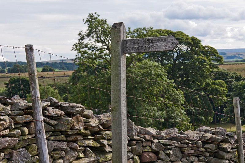
where a signpost directed us on our route.
Initially the track
led along by walls, and just before the last one turned away left,
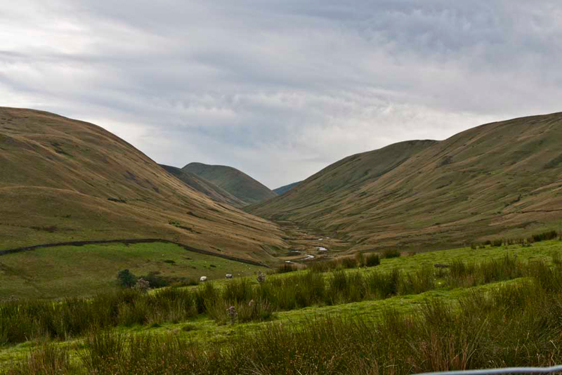
the valley opened up before us.
"Oh dear", sighed Little Eric. "What a long walk we are faced with to get its end and then up onto the ridge." Then he asked what is that distant prominent hill called?"
"That was before I was born", said Little Eric. "So if I am to ever complete this challenge, we will have return there."
Shaun pointed, "We will return along the top of the steep sided fell to the right of the valley. It is West Fell and will be our final summit today."
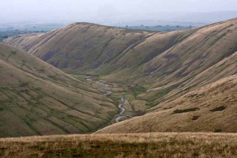
So with best foot forwards we started up the valley proper, the winding Bowderdale Beck running in the bottom towered over either side by the steep sided fells.
Tetley had been studying the map. "I estimate the distance to the head of the valley is about 3.5 miles."
The path runs on the right side along the lower slopes of West Fell and for the most part was fairly level.
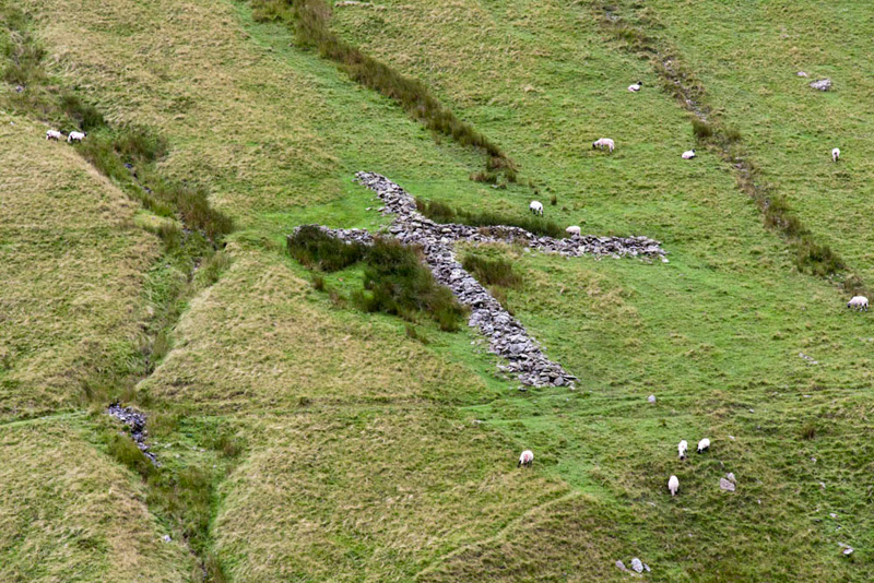
After about a third of the way, Shaun pointed, "according to the map that is an old sheepfold."
Little Eric commented, "the walls having collapsed, it has the appearance of a cross."
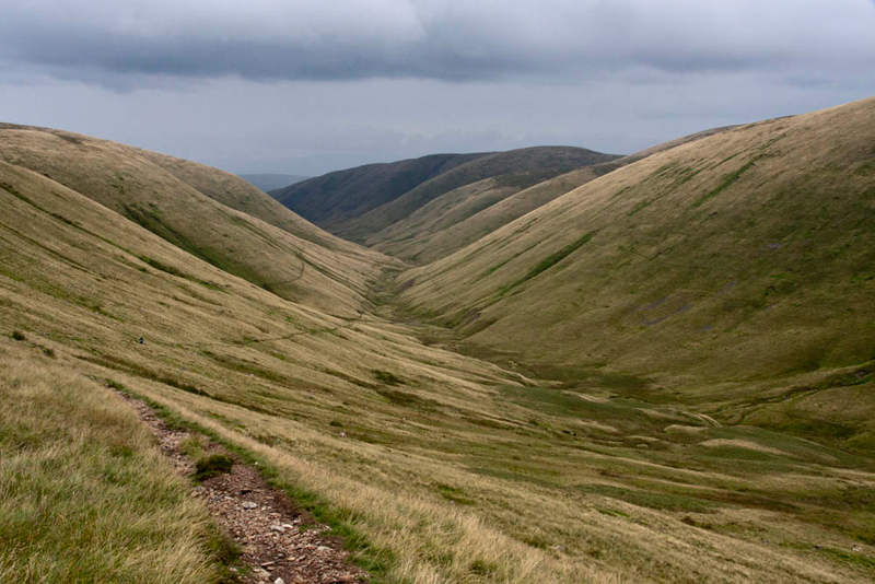
Near the head of the valley the track then climbed up the side of the fell to gain the ridge. "The view looking back is worth a picture Dad", said Allen.
Tetley said, "in the immediate right foreground the slopes are that of Yarlside. The furthest back on the right
is Hooksey, which we climbed just a few months ago on 5th June."
"I love the name", said Little Eric. "Just wonder what the origin is?"
Sadly none of us knew, and the Internet provided no answer either. There were not enough pictures to make a story of that day so instead here we are at the summit of Hooksey.
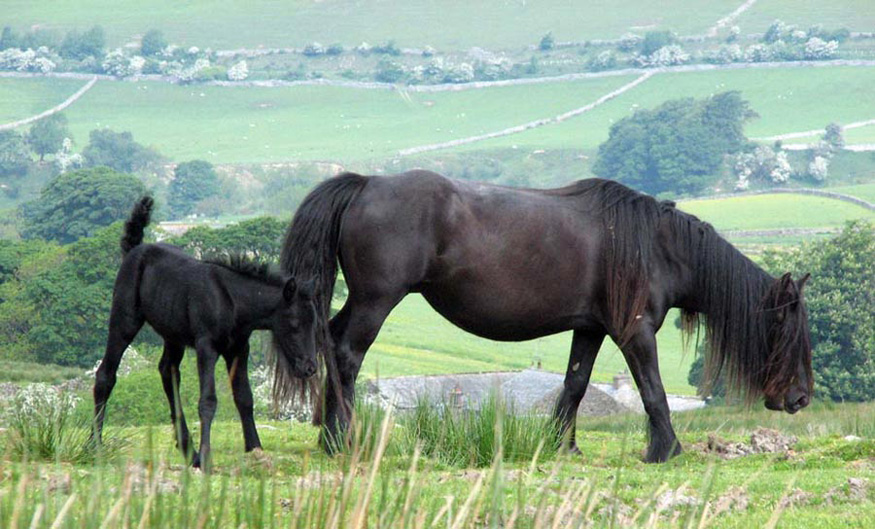
"I recall we were fortunate to see some of the wild horses that live on these
fells, that day too", said Grizzly. "Let's include the one of the horse and foal in this story."
It had been forecast
to be a good day for the weather, but in the hills it can be very
unpredictable, and a heavy shower took a little while to pass
through. This was nothing however to the torrential rain that set
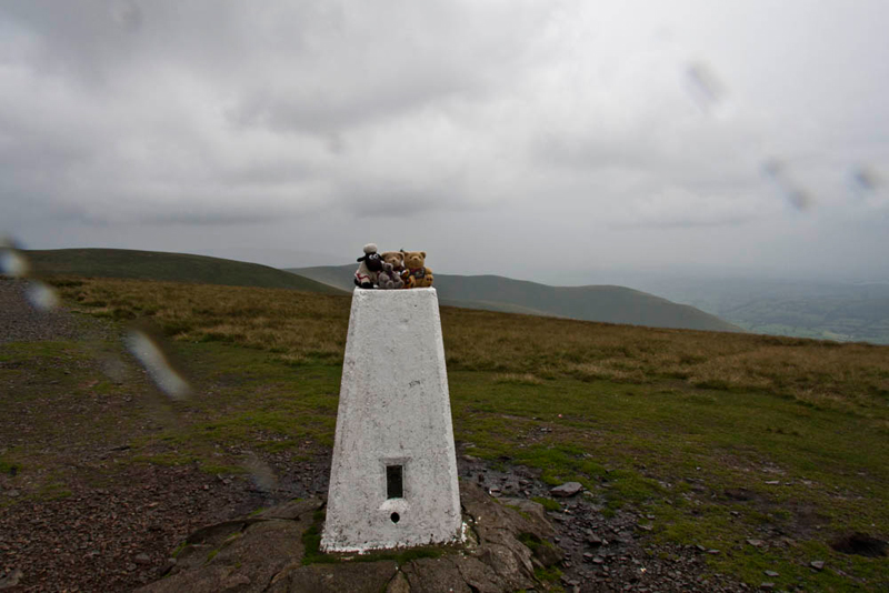
in, in the evening. It made for a for a rather miserable half mile
walk to the trig point on The Calf, that at 2218ft marks the the highest point in the
Howgills.
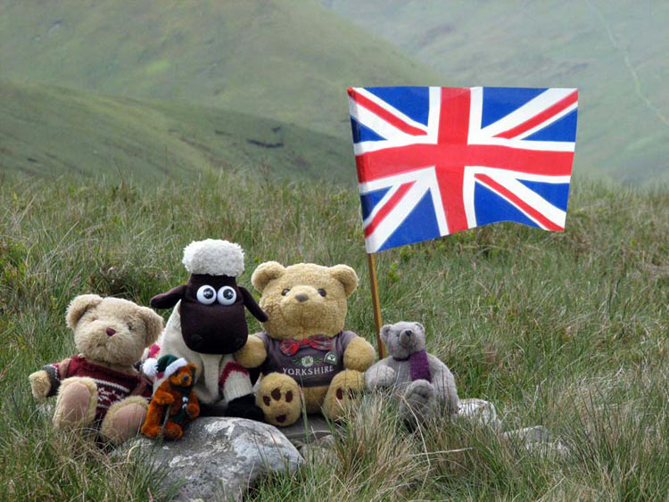
"Thank you Uncle Eric and Dad for making the detour", said Allen on behalf of Grizzly, Little Eric and himself. "All of us in the club have now bagged the summit."
The summit itself is rather uninteresting, but nevertheless and despite the rain, that is evident on the camera lens, we were determined to pose on the trig point to record the achievement."
Safely tucked in the
rucksack again, Dad and Uncle Eric retraced the path towards
Bowderdale Head.
Shaun said, "we have to strike left and pick up the track that runs on the ridge above Bowderdale." As we rewrite this adventure in 2020, we note that it is now part of the long distance path known as the Dales High Way.
The track led us unerringly to Hazelgill Knott, the main reason
for doing this walk. Tetley said, "it is situated in the centre of the fells
and as such cannot be reached without a long walk. I can say with absolute certainty that we are all
glad to have finally ticked it off."
"Quite", agreed Allen.
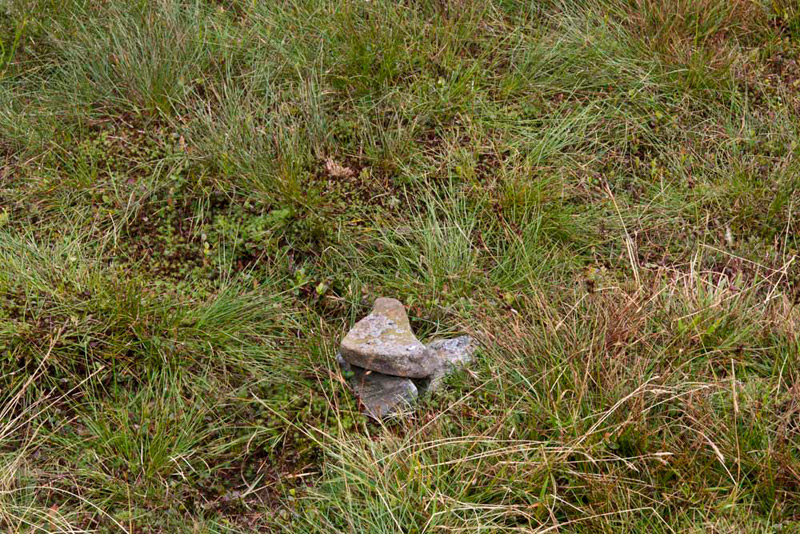
The actual summit, just a few yards to the right of the path, marked by this tiny cairn of just three stones....
...that we clustered round for our picture to mark the achievement.
Looking north west, Allen pointed, "that is the valley called Langdale. It again illustrates just how steep sided the valleys are in the Howgills. The high point on the right side of
the valley is Langdale Knott that we climbed in December last year."
"I like the way the becks meanders sinuously through these valleys like a snake", commented Little Eric.
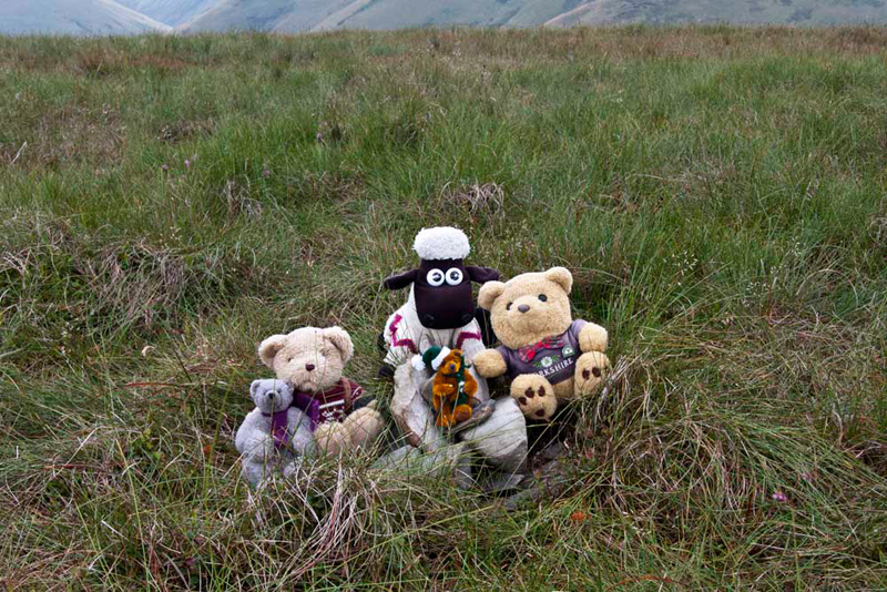
Settled in the rucksack again Dad and Uncle Eric followed the track, where after a steepish descent there was a level section, followed by a gentle ascent to West Fell summit.
"This is our second visit", said Tetley. "We climbed it on 11th December 2007, on the
same day we climbed Langdale Knott."
"My first though" replied Little Eric, "as I had not been born then. So will you please take our picture again?"
"Sure", said
Dad, as we posed by the small pile of stones.
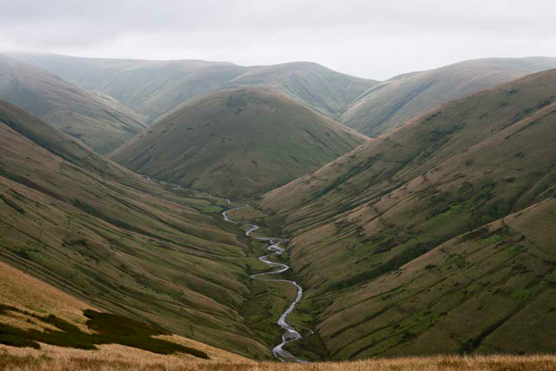
We now had another aspect of
the Langdale Valley, this time looking back to the south.
"Is that Simon's
Seat (1925ft), sitting in the centre at the head of the valley?"
asked Grizzly.
"Yes"
replied Tetley.
"We can
understand, Dad, why you are reluctant to return, as it can be
clearly seen how steep any approach will be", remarked Shaun.
Then we continued
along the ridge descending steadily for about a mile and a
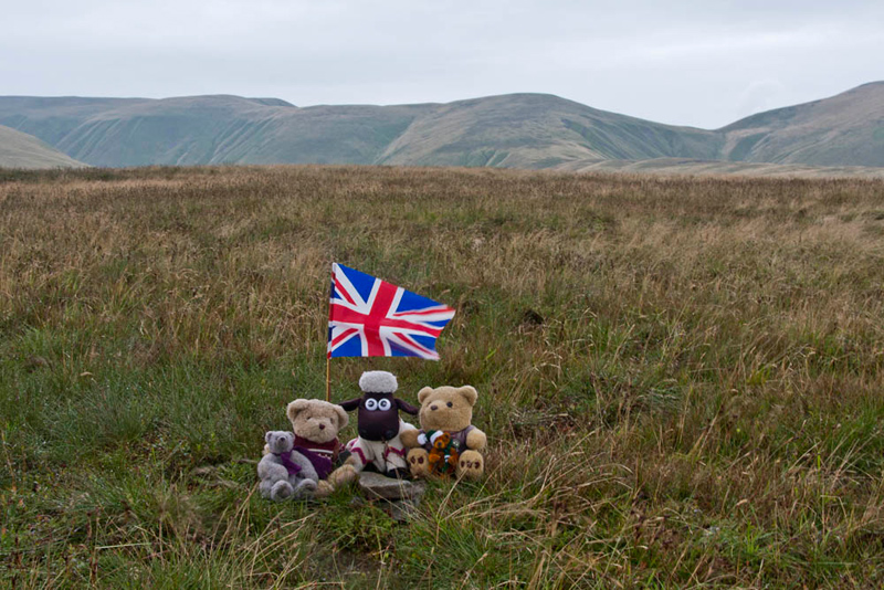
quarter, to join the bridleway that runs through Bowderdale. Keeping ahead on the track by the walls brought us to the road by the signpost, the
subject of the first picture in our story. A short stroll along the road and we arrived at Uncle Eric's car.
It had been a long
walk but interesting nevertheless, and for Shaun, Tetley, Grizzly
and Dad completes our exploration of the northern valleys and
hills of the Howgills. We can say with certainty too that on those explorations we met few other walkers. They are places to be if you want peace and solitude.