ST
RAVEN'S EDGE, JOHN BELL'S BANNER, STONY COVE PIKE &
HARTSOP DODD from KIRKSTONE PASS INN
Allen completes Wainwright Book 2 - Far Eastern Fells
Summary
Date - 15th September 2009
Distance - 5.25 miles Ascent - 1600ft
Map - OL5/OL7
Start point - Kirkstone Pass Inn (NY
401080)
Summits Achieved
Name
Height (ft)
Height (m)
Grid Ref
St Raven's Edge
1946
593
NY 4060 0837
John Bell's
Banner
2477
755
NY 4128 1007
Stony Cove Pike
2503
763
NY 4186 0999
Hartsop Dodd
2028
618
NY 4113 1185
Preface
Shaun, Tetley and Grizzly were
looking over the records of their recent walks.
"It's ages since we walked
with Uncle Eric", remarked Tetley.
"I know", agreed Grizzly,
"but not for want of trying. If only the weather would
improve, so they don't have to be called off"
"Here comes Allen, and he
looks excited too", said Shaun, looking up.
"Good news", cried Allen
breathlessly. "Dad has just spoken to Uncle Eric and we are
going walking tomorrow"
"Where too", inquired
Little Eric, who had just wandered in.
"We are climbing Caudale Moor
and Hartsop Dodd, so I will finally finish Book 2. We are also
taking in St Raven's Edge, which is one of the Birkett tops we
have wanted to do for ages."
"That's just great",
cheered Tetley, "roll on tomorrow morning."
The Walk
Tuesday dawned with blue skies and
there was to be plenty of sunshine. It was rather windy at first,
but this dropped considerably as the day went on. As a
consequence there was clear visibility so we enjoyed superb views.
The start and finish points were not the same, and to return to
the start would have meant a long and arduous walk for Uncle Eric
and Dad along the road up the Kirkstone Pass. To avoid this Dad
met Uncle Eric at the end, where he left his car, and we all
drove to the start in Uncle Eric's brand new car. It is very nice
too!
The start was from the Kirkstone
Pass Inn. This is the highest pub in the Lake District at 1480ft
(450m) above sea level. Overall it is the third highest in
England, behind The Tan Hill Inn in North Yorkshire (1730ft) and
the Cat and Fiddle in Cheshire (1690ft). It is a popular stopping
place for coaches, that disgorge their passengers to look at the
views. About three stopped while we were getting ready for the
off! "Can't beat being on the tops though!" said Tetley.
Ready for the off, Shaun directed, "it's up that rough path to a stile."
Then the path continued steeply as a rocky scramble to the
ridge, marked by a large cairn. As we had climbed up, there had
been great views.
When Uncle Eric and Dad paused for
breath, Tetley called out "there are some good photo
opportunities, don't you think Dad."
"Yes", he agreed, and
immediately got the camera out
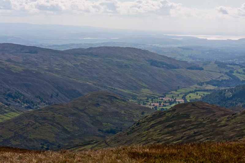
First this is the view over to the
northern reaches of Windermere and beyond. Allen said, "there's the road to Ambleside. It is very steep and is nicknamed 'The
Struggle'."
Immediately below were the
buildings of the Kirkstone Pass Inn, from where we had started. Our ascent path can be seen bottom right.
Because it was such a large cairn,
Little Eric asked, "is this the summit of St Raven's Edge."
"No pal", replied Grizzly. "We have to walk north
along to those rocky outcrops a short distance ahead, as they are
the summit according to the Ordnance Survey."
This was soon accomplished. Allen saying, "great, that's another Birkett ticked off. Come on time for our usual summit picture."
"That's Red Screes behind us", said Shaun. "We have climbed it twice in the last 12 months."
"That's right pal. First in December last year when there was thick snow", replied Tetley. "That day we had planned to do other summits but the weather forced us to abandon the attempt. These were finally climbed just over a week ago, ending up back on Red Screes."
"That turned into a very wet day and we were pretty soaked by the time we had made the descent", added Little Eric.
Having got settled in the rucksack once more, Shaun instructed, "we follow the path along the edge to its end, and then bear right to start the ascent of John Bell's Banner, towards
Caudale Moor."
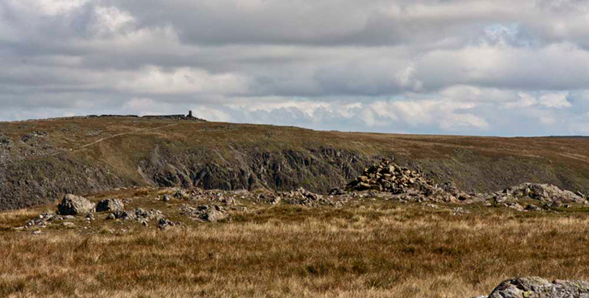
At this point we could look back to St Raven's Edge.
Approaching the highest
ground, Grizzly said, "it would be nice to visit then Mark Atkinson memorial. Just go left and cross the wall."
Mark Atkinson was the landlord of
the Kirkstone Pass Inn. He died in 1930 aged 60. The more recent
plaque on the right is to his son William Ion Atkinson who died
in 1987 aged 83.
"We head north-east to get to the summit cairn of John Bell's Banner on Caudale Moor."
It was flying
too. Well, that is when Dad set us on the cairn with the Union
flag, for our picture! Grizzly said, "John Bell's Banner primarily refers to a boundary mark. Banner is from baner (standard, banner) that is Middle English from Old French. John Bell is a personal name of the person who probably witnessed a deed. This is according to Diana Whaley's book on Lake District Place Names."
"Do you know about the name Caudale Moor?, asked Allen.
"Caudale is 'the cold valley' seemingly from its north facing situation. This is from the Old Norse kaldr meaning 'cold' and dalr for 'dale'."
"Thank you pal. As always you add interest to our adventures."
While there are striking views to
the Helvellyn Ridge, Tetley said, "if we walk just a few yards north a
wonderful view to Ullswater will be revealed, with Brothers Water below in the angle of the fells. To the right is Place Fell with immediately below Hartsop Dodd, our last summit today. The bare fell above the trees left is High Hartsop Dodd, that we summited a week last Sunday."
"That is truly breathtaking", called out Little Eric.
"I could stand and look at the view for much longer, but we had better be getting on", said Uncle Eric.
Shaun issued instructions, "walk south to the wall then follow the clear path east that climbs gently."
Starkly to the left were the
fells forming one side of the Kentmere Horseshoe. "Wow, superb", called out Allen. "From left to
right is Froswick, Ill Bell with its tall cairns, and Yoke.
"A superb view into the Troutbeck valley too", pointed Grizzly. "The fell in the centre left is Troutbeck Tongue, which we climbed last November."
"Morecambe Bay in the distance. Let's give Uncle Brian a wave", called out Allen.
The path soon crossed the north/south
wall to very quickly approach the summit cairn at Stony Cove Pike.
"What's that over there to the
east", asked Little Eric.
"That is Thornthwaite Crag with its distinctive tall cairn",
replied Shaun, knowingly.
"There is a path going that
way", persisted Little Eric.
"Yes, confirmed Tetley. "It
descends steeply to cross Threshthwaite Mouth followed by a steep
climb of some 620 ft to Thornthwaite Crag.
"Ooh that sounds like hard
going", replied Little Eric.
"Well fortunately that is not
our route today", said Grizzly
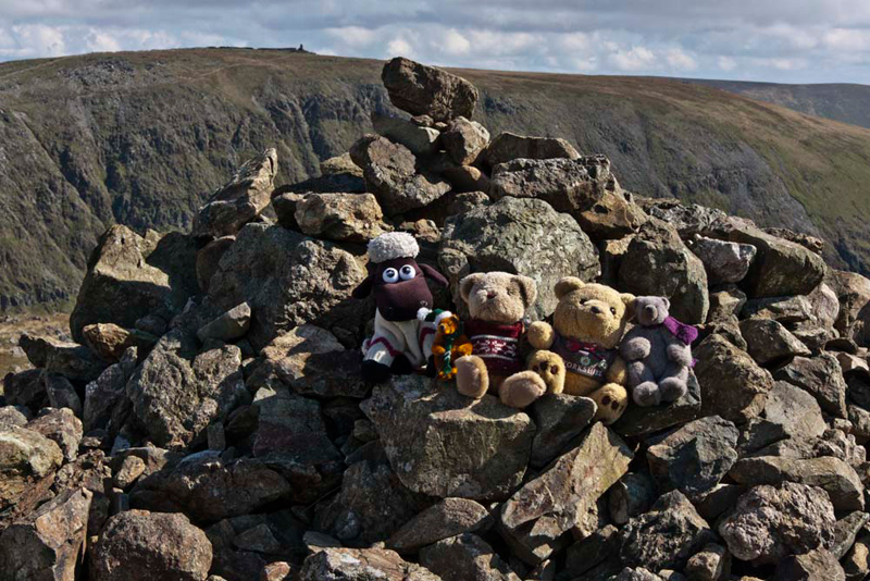
Tetley said, "the cairn at Stony Cove Pike is the highest point at 2503ft, and is the Wainwright summit in Book 2,
which he refers to as Caudale Moor."
We quickly hopped out and clambered onto it. "Great", cheered Allen, "that's another Wainwright you and I have ticked off Little Eric."
"According to Diana Whaley, this is 'the peak by Stony Cove'. Stony is from the Old English stanig ", Grizzly advised.
"Time for lunch", said Uncle Eric, we will be sheltered from the wind behind the wall."
"Ooh yes" replied Allen rubbing his tummy in anticipation. "I'm hungry."
"Your always hungry", laughed Tetley.
So we settled for a pleasant little while eating our sandwiches and cake and having tea, while enjoying the views.
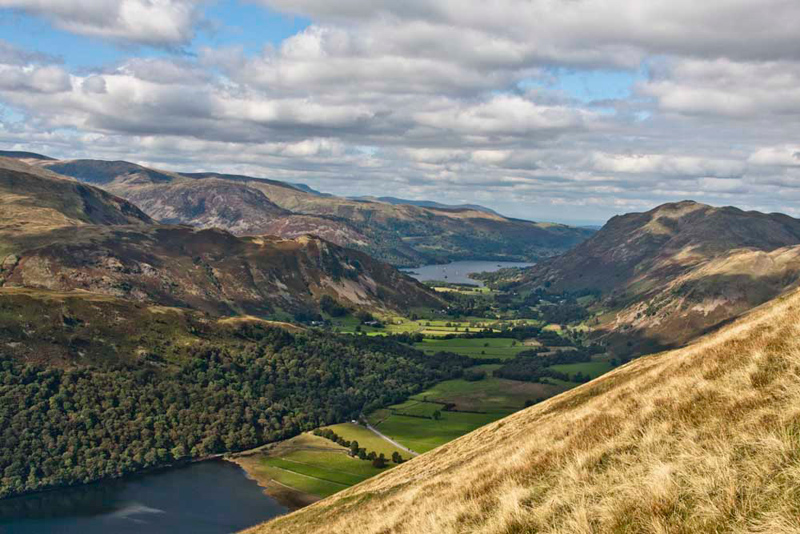
This over Shaun said, "the wall is our guide north leading all the way to Hartsop Dodd."
This can be seen plainly, in this
picture taken earlier from John Bell's Banner. The higher fell
rising behind is Place Fell.
First the route descended towards a col. Looking left, Little Eric said, "what a superb view. What can I see?"
"The long ridge in front is Hartsop
above How, rising to Hart Crag. Right of that is Fairfield its ridge falling to Cofa Pike. The long fell behind is St Sunday Crag.
Behind that at the left end is Dollywagon Pike and Nethermost Pike, with Helvellyn just poking above the right end", said Tetley.
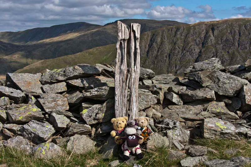
From the col a short gentle climb brought us to the summit, where Allen let out a "yippee. I have finally completed all the summits in Book 2 - Far Eastern Fells."
Well done pal", said Grizzly, as we all gave him a hug.
There is a now a cairn just a little way
from the wall, but the fence post that Wainwright notes as the
summit, still stands against the wall. It is clearly the
highest point.
"You must sit on your own to mark the achievement, pal", insisted Little Eric.
We then all gathered for the group picture.
"Is that Brother's Water,
below?", asked Little Eric.
Not having walked as extensively in
the Lakes as the rest of us, Grizzly helpfully replied, "Yes,
and it is in fact the smallest of the 18 stretches of water that
are designated as lakes."
"It has a lovely blue colour
today", said Allen.
"Yes", agreed Tetley.
"Please take a picture Dad".
This too of the wonderful view towards Ullswater. "Oh just stunning", called out Little Eric.
Shaun said, pointing across the valley to Dove Crag, "Wainwright tells walkers to aim for this as the line of descent."
Uncle Eric soon spotted another old fence
post as we expected, then soon afterwards we found the groove.
This criss-crossed the fell on its steep 1400ft descent all the
way to a green path. This soon led to the road, and a short walk
along this brought us to where Dad had parked his car. It was
just a few minutes drive to the top of the pass and Uncle Eric's
car.
"Another great adventure under our
paws, thanks Dad, as always", said Grizzly.
We all bagged St Raven's Edge,
while Allen & Little Eric bagged the other three tops.
Shaun said, "it is the second visit for Tetley, Grizzly and I, but so glad to have done them again, as that day there was thick mist so the views were obscured."
Time for tea now - what a surprise!
Uncle Eric and Dad went to one his favourite cafes Wilfs, at
Staveley. Dad had tea and a large piece of cake too, of course.