We were having a
relaxing afternoon, enjoying a steaming mug of tea and biscuits,
when Grizzly remarked, "well after that mammoth expedition
to Ennerdale, we have now just two Birkett summits to go, to
complete the challenge."
"That's right pal",
enthused Allen, "and just maybe we will get them done before
the days get too short."
"There is however
that niggling doubt concerning whether we actually reached the
summit, when we climbed Bigert in October 2008", replied
Tetley.
"I'll get the map",
said Shaun, going to the drawer, and taking out OL6 - The English
Lakes, south western area. Opening it out, he said, "here's
Bigert."
Tetley was looking
over his shoulder and said, "we walked to the road end
beyond Hole House, and then on along the track that climbs along Bigert's
lower slopes, to beyond the gate in the wall. There we climbed left
beside it."
"That's right pal"
replied Shaun. "The wall then intersects with that new fence,
and the spot height is shown beyond this. And, thereby rests our
doubt, as we did not cross the fence. Dad took our picture by
those few stones that seemed to be a cairn just before the fence."
"Unless we climb
it again, we will always have that niggling doubt", said
Grizzly.
"I know",
said Allen, draining his mug, "I had better go and ask Dad
what he thinks."
"Another mug of
tea, Tetley?", asked Little Eric.
"Yes please pal,
and you had better pour another one for Allen, as you know what a
tea belly he is."
It was not long before
he was back. "Thanks pal", he said, accepting the
refilled mug from Little Eric.
"Dad agrees, that
there is some doubt about this fell, although he thinks that the
OS map may not be completely accurate, but nevertheless we need to
do it again, and it will be our next walk."
"I guess we will
be starting from Ulpha Bridge, as the parking is so limited by
Hole House, immediately below the hill?", queried Grizzly.
"Yes pal",
replied Allen.
"Well there's one
thing, it will make a nice change not having to drive to the
north Lakes, and so we will not have to be up and away very early",
said Tetley, with relief in his voice.
The Walk
As Tetley had predicted, it was mid-morning
before Dad was ready, and hearing the boot of the car slam shut,
we dashed to the car, calling out our goodbyes to Uncle Brian.
"Have a good time lads", he called back. "Make sure Dad takes care, especially after all the rain we have had recently."
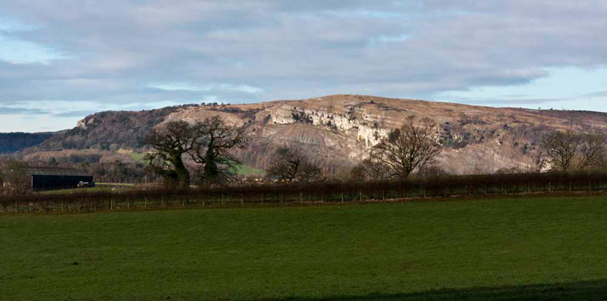
The drive was along the A590 Barrow road, passing below
Whitbarrow Scar.
"We have made a few ascents of
that", remarked Allen.
"Quite pal", replied
Tetley. "Great views too, despite its modest height of 700ft."
Here it is, taken from Leven's
Bridge, in March 2009, while Dad was waiting for Uncle Eric to
arrive for a walk. The usual ascent is made via the woods at the
left end, then traversing right across the scar to its summit,
called Lord's Seat.
According to Diana Whaley, the name means 'the white hill'. Viewed from this side we can see why."
At Greenodd we turned right,
heading towards Broughton. Passing Gawthwaite, Little Eric called
out "there's Burney, which I ticked off earlier this year."
The main road bypasses Broughton
village, and soon we reached Duddon Bridge, where just before we
turned right along the narrow winding road up the valley. After a
while it became unfenced, and our lovely Herdwicks were grazing
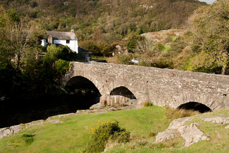
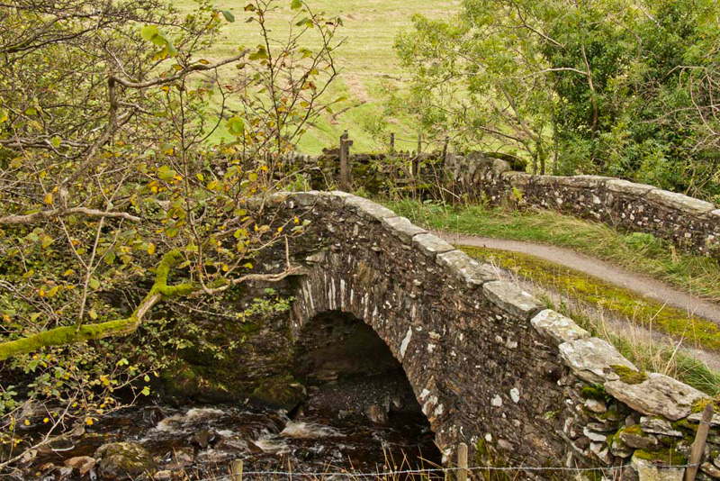
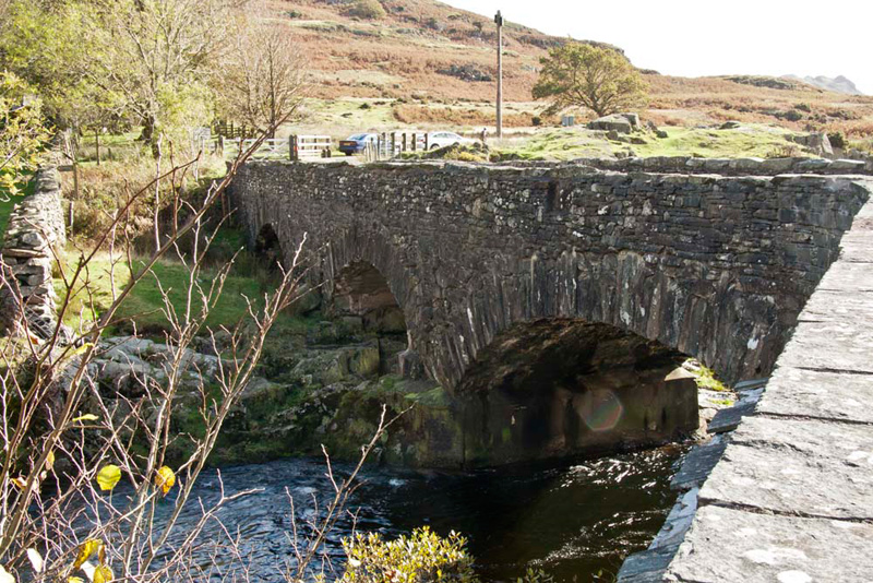
the verges. Soon we arrived at Ulpha Bridge.
Grizzly said, "it probably
dates from the 17th or 18th centuries. The main left arch spans
the river, the other two being for flood water."
As can be seen the sun was shining
and there was little wind too, in contrast to the recent spate of
rain and gales. This however was just a respite before more wet
weather arrived for the weekend.
Dad got ready, so we got settled securely in the rucksack, "We cross the bridge", advised Shaun, "then by the house at the corner take the road signed to Bootle."
Before doing so, Dad paused to take this
shot of the River Duddon, sparkling in the sunlight.
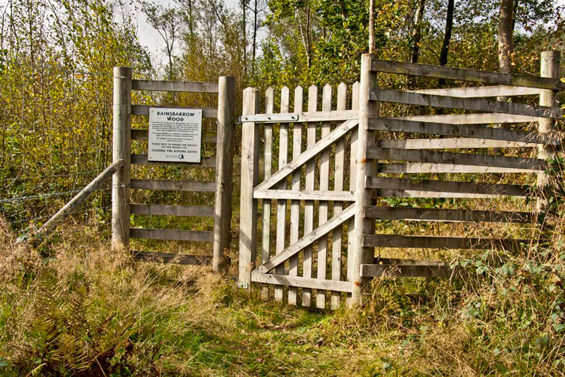
Approaching the old bobbin mill, Shaun instructed, "go right into Rainsbarrow Wood, and then
immediately left."
The muddy overgrown path wound its way over the slopes of Hard Hill. We do not think
the path is walked very often, which was perhaps just well in
view of the incident that happened at the first tall kissing gate.
An area has been fenced to allow native woodland to regrow, and
as can be seen this had clearly been successful.
The gate has a chain and hook
fastening, and after a minute or so Dad was no nearer to getting
it open.
"What's the problem?"
asked Tetley.
"Well lad, somehow when it was
last fastened a link in the chain has got wedged against the hook,
and I just can't free it", replied Dad in exasperation.
"What is needed is a sharp blow with a hammer, but that is
not standard kit when we are walking."
"Oh heck", said Little
Eric, "whatever are we going to do."
"I'll just have to climb the
fence surrounding the gate", replied Dad promptly.
This was easy, but as he got over
the map caught on the top of the fence, but then came free. We
thought nothing more about this, but in fact what we all failed
to notice was that this caused Dad's GPS & case to come off
and fall to the ground.
The path climbed steadily to come out of
the wood via another tall kissing gate whose fastening presented
no problem, and on over a pasture and further rough ground to a
stile and gate.
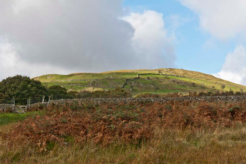
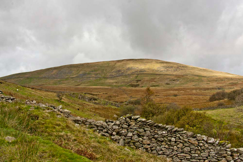
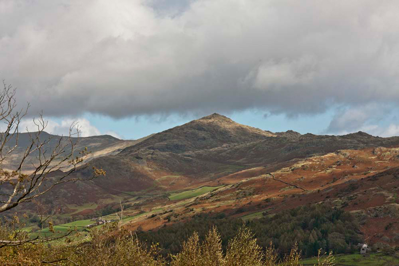
"There's Bigert", called out Allen, pointing ahead.
Reaching for the GPS, Dad exclaimed, "its gone!"
"It must have fallen off when
you climbed that first kissing gate", said Tetley.
"Oh heck", cried Little Eric, "We'll have to go and get it. Hopefully it will still be there."
Dad hurried and to everyone's relief, it was
lying there on the ground.
"Phew!!", said Tetley.
This there and back, added
about another half a mile to the walk. Now however all went to
plan.
As we reclimbed, Little Eric said,
"what's that fell over to the right."
"The Pike", replied
Tetley. "We climbed that with Hesk Fell on a misty day in
February 2006."
"That was before I was born,
so if I am to eventually complete the Outlying Fells, we will
have to repeat them", said Little Eric.
Beyond the stile, the path comes
above the gill. The map shows a way across this to Hole House,
and indeed there is a waymark pointing to it.
Shaun said, "we tried that
path last time but the route has disappeared, so instead we need
to climb the stile in the wall on the right."
"Thanks", replied Dad.
Beyond we crossed the pasture
diagonally left, to climb the stile in the wall, and then up the
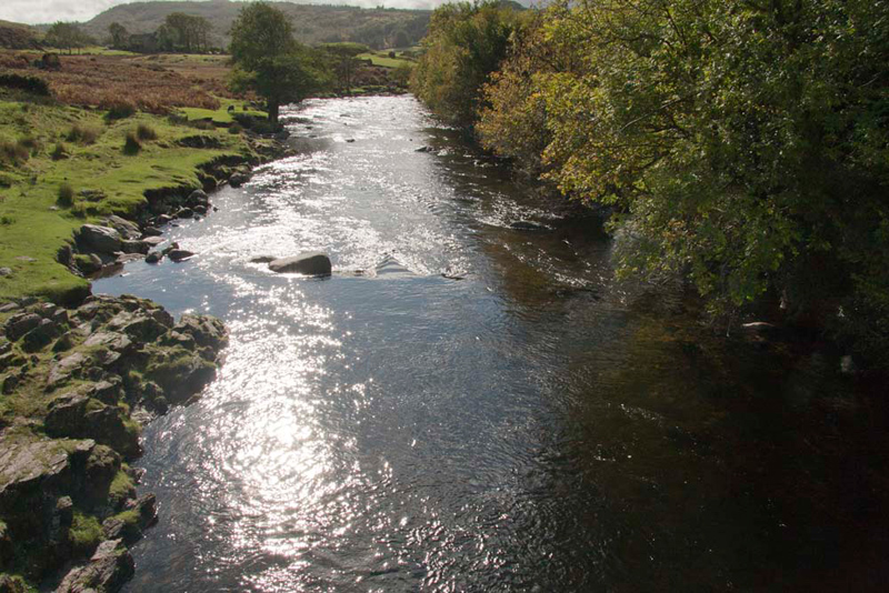
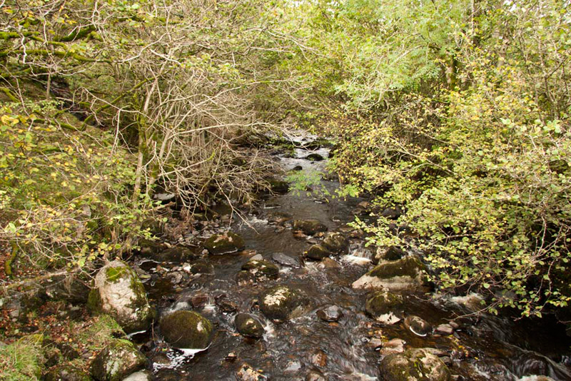
pasture to the access track to Pike Side Farm. "Go left along the track to come to the narrow bridge over Holehouse Gill", advised Shaun.
Crossing Dad paused to take this pleasing picture, looking upstream.
So, with the approach walk done, we
could now get on with climbing Bigert. Over the bridge, we
immediately turned right through a gate, and climbed steadily the
rough track passing through two more gates.
Looking right, Tetley said, "Little Eric, that is Hesk Fell, that we will need to climb again for your Wainwright Outlyer challenge."
Beyond the second
gate, we left the track immediately to climb up the steep rough
grassy slope by the wall/fence. As the ground levelled, we struck
right to the grassy knoll, with the few stones that is supposed
to be a cairn.
Shaun got the map and peering
closely said, "there is a spot height shown here, but
without a number." Looking round he then went on, "we
crossed the remains of a wall just before the knoll, which is
what the line on the map represents, rather than the new fence.
So this spot height is just where we are now."
Tetley was standing by Shaun
and replied, "I agree pal, but the map does also show the
331m spot height, some little distance on beyond the fence."
In the meantime, Allen had taken
his rucksack off, and was looking hopefully at the flasks of tea
inside, but his face fell, when he heard Dad's reply.
"Well lads,
what we will do is cross the stile over the fence and walk
towards that point."
Noticing Allen, Grizzly said,
"it's not that far pal, and we will soon be back here, so we
can all have a mug of tea then."
"OK", replied Allen his
face brightening.
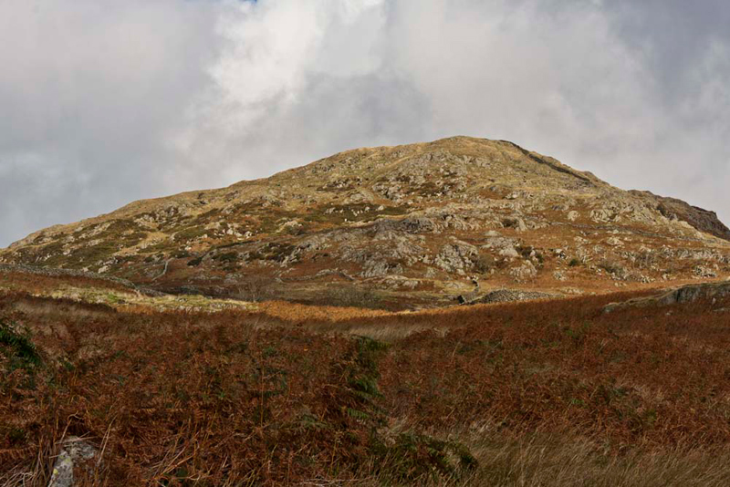
So off we went crossing the brown
dreary and boggy ground towards a slight prominence in the
otherwise flat area.
As we reached this, Tetley looked
back said, "the grassy knoll is definitely higher."
Then reading the Birkett book, he went on, "and that knoll
is the summit that he describes in his book."
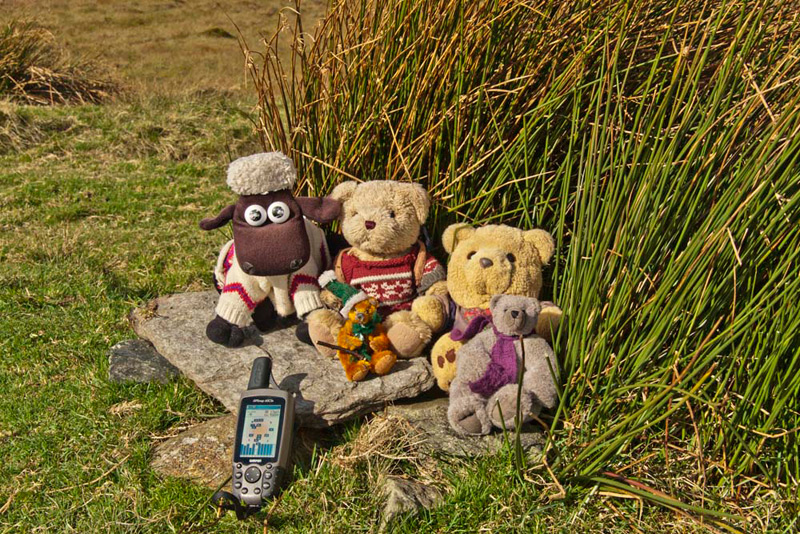
So, all of us happy,
we returned to the knoll, where we settled by the stones for our
summit picture.
Slipping his rucksack off again, Allen passed
round the welcome mugs of tea, which we had with a chocolate
biscuit.
"Thanks pal", said Grizzly, on behalf of the rest of us.
Meanwhile Dad had some water and a mars bar.
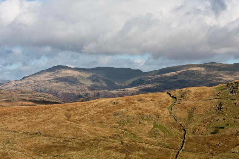
"That view of the Coniston Fells is worth a picture for our story", said Grizzly. He then set the scene, "Dow Crag is to
the left, with Coniston Old Man in the centre and to the right Walna Scar and White Maiden."
Ready for the off, Shaun said, "it's just the case of retracing the route to and across Holehouse Bridge."
There he directed us again, "if we climb that step stile we will cut off the corner of the drive to Pike House
Farm."
Our outwards route was
now followed, and as we crossed the pasture towards the tall
kissing gates, Grizzly called out, "there's the southern Caw
its summit at 1735ft. It was only last week that we climbed its northern
namesake above Ennerdale that is somewhat higher at 2288ft."
At the second
kissing gate, Dad once again tried again to free the fastening. After pulling hard he sighed, "it's no good. As I said before it needs a hammer blow to free it."
So again he agilely climbed the surrounding fence,
taking care not to leave the GPS. Out of the wood, it was then back along
the Bootle road, to Ulpha Bridge, and the car parked on the rough
layby, just beyond the cattle grid. From this side it can be seen
more clearly that the two far arches are for flood water.
As we settled in the
car, Allen piped up, "I guess it's time for a late lunch Dad?"
"Yes lad."
"We know where
you will be going too", said Tetley. "Jane and Sam's at
Low Newton, but that is great because we get to go in too."
Here Dad had delicious
sweet potato & leek soup, served piping hot with crusty bread.
This was followed by the delicious apple & blackberry crumble
with custard. Tea to drink.
Rather quiet by the
time we got there, there was a couple in who were regulars, and
Dad joined in the conversation with them. The lady noticed and
admired us, and thought Dad taking us on the hills was great and
she loved the idea of the stories.
She said "they
are not just Teddy Bears but REAL."