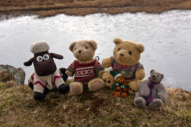
Tetley was snoozing, while Little Eric and Shaun, were each reading one of the Wainwright Pictorial Guides.
"They are truly amazing", said Little Eric in wonder. "It is mind boggling to think of the hours upon hours he must have spent handwriting the pages and doing the wonderful drawings.
"And that was after he had spent the many days climbing all the fells by the many different routes, to gather the information", added Shaun.
Just then their quite reverie was broken, and Tetley was rudely awakened by the whirlwind that was Allen dashing into the room. "I bring news of a walk on Thursday, with Uncle Eric."
"Where?", asked Little Eric excitedly.
"From Brown Howe car park on the shore of Coniston Water, then doing a circuit over Torver Low Common and Torver Back Common", he replied.
"We don't know much about the area, except that it is again one we have not walked before", said Tetley. "It just goes to show there is still lots of new ground to explore."
"I'll get the map so we can get a feel of where we will be walking," suggested Shaun.
"How about I pour some tea, as I'm gasping for a cuppa", said Allen.
"Watching Dexter, with Dad and his other TV pals", responded Shaun.
"Oh dear, so I suppose there is no chance of any cake", said Little Eric mournfully. "I was so looking forward to a piece of chocolate caramel shortbread. It really is so scrumptious."
"I heard that", said Grizzly, as he walked into the room with cake tin in paw. "The program has just finished, so I thought I would bring the cakes. There is no chocolate caramel shortbread, as you ate it all up yesterday, but I have made some apricot and cherry slice, which I hope you like."
"Lovely", exclaimed Little Eric, "all your cakes are just delicious."
Meanwhile Shaun had spread the map out and pointing said, "there's the parking at Brown Howe. From what you said Allen, we must go west on this narrow road, then past this old reservoir and out to the main road. Then crossing it and over by Long Moss Tarn and down to the lake and so south beside it to Sunny Bank."
How do we complete the circuit then?", queried Grizzly, as he munched away on another piece of cake.
"By taking the path up beside Tyson Wood, to meet the outwards route near Stable Harvey", replied Shaun.
"Oh yes, I see. Thanks Shaun"
"More tea anyone?", called out Allen, as he filled his mug again.
"Yes please", replied Tetley. Then once filled, he raised his mug, "here's to Thursday's walk."
"Hear, hear", cried Little Eric.
The Walk
We woke up to a bright morning, but it was still cold despite the fact that the easterly wind was not blowing today. Uncle Eric and Dad had decided due to the cold, not to have a picnic today, but rather find somewhere to eat after the walk.
With this in mind, Tetley said, " we still need to pack a picnic for ourselves, to eat in the car after the walk.
"I'll see to the cake", said Grizzly. "There will be fruit scones, and I have made some chocolate caramel shortbread to keep you happy Little Eric."
"Thanks pal", he replied.
"I'll help you with the sandwiches, Tetley", said Allen. "What filling have we got for today?"
"Well, there is cream cheese, and I also got some smoked salmon", Tetley replied. "It will be nice to have a more upmarket picnic today."
"Will there be champagne, then", piped up Little Eric.
"Now you are being silly", admonished Shaun. "It will be tea, as usual. Anyway we need a hot drink on a cold day like today."
Usually this is stowed in Allen's rucksack, but as we were having it after the walk, we put the food instead in plastic boxes, which were placed carefully on the back seat of the car. Then we settled ourselves on the front seat, ready for the off.
To get to the start it was along the ever so familiar A590 to Greenodd then turning right on the A595 to Lowick, where we took the right fork. After a while the road came close to Coniston Water and very soon we arrived at Brown Howe, pulling into the car park just behind Uncle Eric.
We called out a cheery, "hi Uncle Eric, nice to see you", as he got out of the car.
"Nice to see you too, Lads", he replied.
As he and Dad got ready, we jumped into the rucksack and settled ready of the off. Before doing so, Uncle Eric explained, "the first part over Torver Low Common I devised myself, while the part on Torver Back Common and by Coniston, is from a walk published in the Westmorland Gazette."
"Thanks for that", said Shaun.
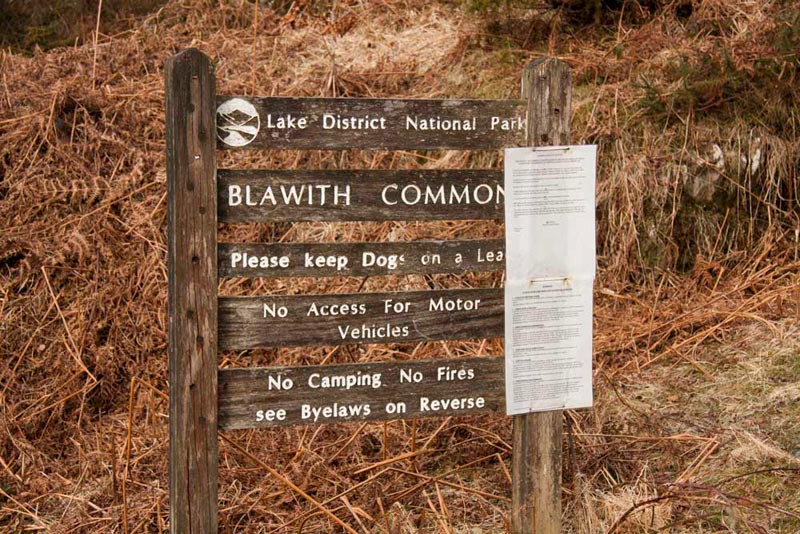
With our backs to the lake, we walked out of the car park via its entrance, then crossing the road and walking left for a few yards. Then it was right on the narrow lane, where almost immediately we passed this sign.
"I thought we were going to Torver Common?", queried Grizzly.
Glancing at the map Shaun replied, "the area to the left of the road and for over a mile south, is indeed Blawith Common. We however will be heading north, which is where Torver Low Common is."
Meanwhile Allen had been reading the sign, that set out the rules, and piped up brightly, "there is no mention of bears not being allowed so we are OK, and of course there will be sheep roaming about, so Shaun is OK too."
The lane meandered on and we saw the path off left leading to Beacon Fell and Tarn, both of which we had all visited before. Finally the lane ended at a gate and the access track to Stable Harvey Farm.
There was a choice of route here. Either ahead by the wall, or left on the bridleway. This latter seemed to bend away south, not the direction we wanted to go, but was in fact the correct route. This would have been plain too, if Dad had looked at the map properly. Instead we wrongly took the path by the wall, rather at Dad's insistence and he apologises unreservedly to Uncle Eric for this error. This meant we had to cross the hill marked Tottlebank on the OS map and then deviate rather steeply down and left over rough ground to finally get on the correct path.
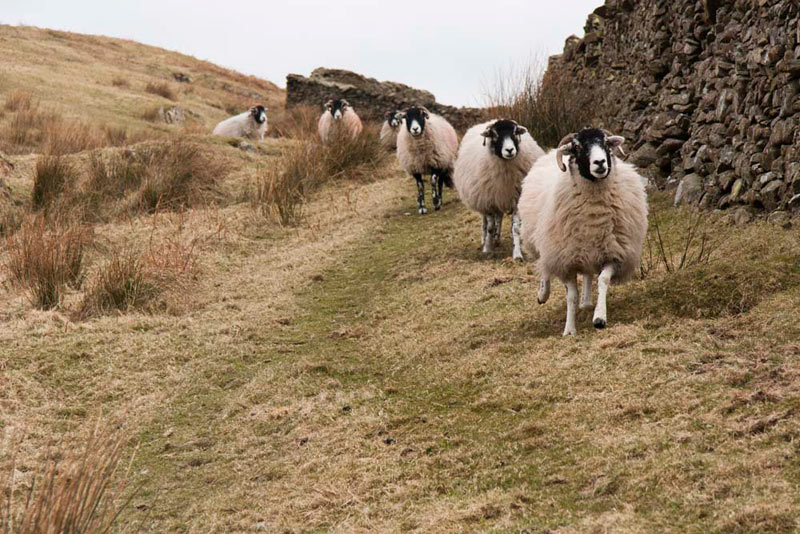
As we set off, we were suddenly faced with a line of blackfaced sheep, who completely ignored us, being bent solely on getting down the fell to where the farmer had brought fodder. As can be seen, with the prolonged cold weather, the grass is not growing, so farmers are having to bring the fodder, so their sheep do not go hungry.
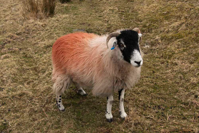
One, however, who perhaps was not so hungry, was good enough to stand while Dad took a picture.
"Well, once again our plan to write about the adventure without any sheep pictures, is out of the window", cried Allen in exasperation.
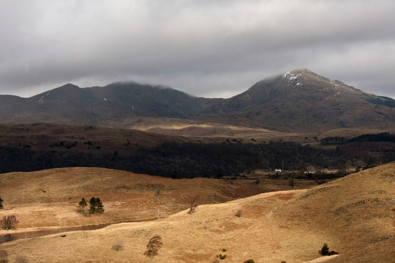
From the top of Tottlebank, the view opened out to the west, with this dramatic shot of the Coniston Fells.
"That's Buck Pike (2441ft/744m) and then Dow Crag (2554ft/778m) with cloud on its summit", said Tetley. "Then the depression of Goats Hause, that rises to The Old Man of Coniston (2633ft/803m) on the right."
Dad timed it just right getting this shot of the fells, as with the deteriorating weather they soon disappeared in the lowering cloud, a precursor of the rain to come.
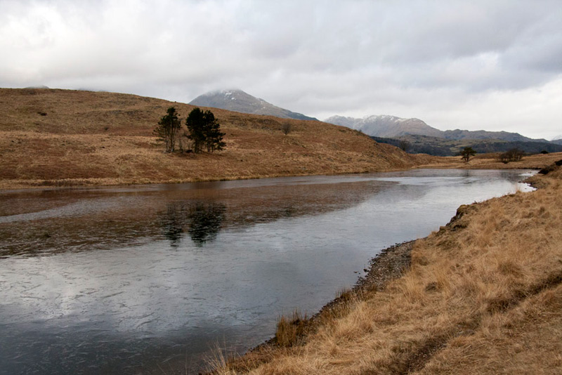
In the sunny foreground of Torver Low Common, nestles Throng Moss Reservoir, which was our next objective.
Uncle Eric said, "it is not named on the OS map, but I can assure you that is what it is called."
Here it is, looking north, with the backdrop of the Old Man of Coniston and Wetherlam.
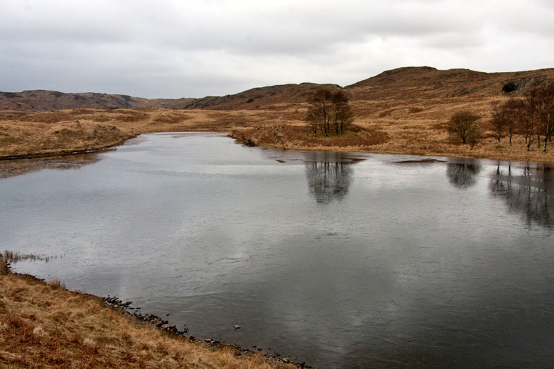
Normally we would just leave it at that, but this shot looking south along the reservoir was nice too, with the reflections of the trees that stand beside it. As a reservoir it is long disused, as the OS map indicates. There is little or no information about it on the Internet, but Dad speculates that it may well once have provided water to the nearby village of Torver.
In the first picture a path can be seen by the reservoir and we followed this north north-east over the common and then descending to a gate. The track, now walled, led down to cross the Torver Beck by Mill Bridge. Just before on the left was a large house.
"I reckon that was the mill, long ago", said Uncle Eric. "It would no doubt have been powered by the beck."
He was quite right too, as we looked it up on the Internet. The mill was a corn mill and fulling mill. Fulling was done by beating the cloth in the fulling stocks, which are heavy wooden mallets raised by wheels with projecting cams. Nearby is a field called 'Tenterbanks' where the cloth was then stretched on frames (tenters) being attached to it by tenter-hooks. This is the origin of the phrase, 'being on tenterhooks', when one is apprehensive about something. When milling ceased, the property was converted to cottages in 1911-12.
Over the bridge we continued along the track passing a house called Beckstones, to reach the main road.
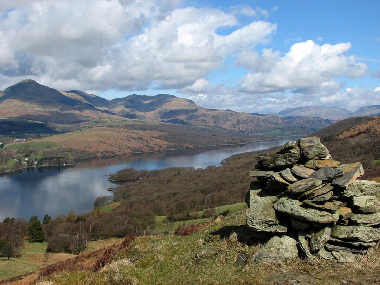
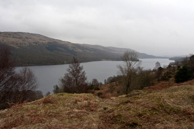
The next part of the walk, basically that published in the Westmorland Gazette, was over Torver Back Common, then down to Coniston Water and along the shore following part of the Cumbria Coastal Way. This can be illustrated in the picture below taken on 19th April 2006, from the lower summit of Brock Barrow. On the the far side of the lake, there are a few houses at the left of the picture which is Sunny Bank. The predominately brown area to the right is Torver Back Common, below which was our shore side path. Towards the furthest point of the area, it is possible to discern that there is a small valley running left to right and in this lies Long Moss Tarn, which we were to visit.
The first thing however, was to find the path off the road to Kelly Hall Tarn. This is not marked on the map, nor was its location properly described in the narrative. Dad and Uncle Eric walked in opposite directions but neither found the path.
However Dad wants to apologise once again to Uncle Eric, as he did not really walk far enough towards the Land Rover garage, otherwise he might well have found it, probably through one of its parking areas.
Instead we climbed up by a wall further south on the road and then over a stile in a cross fence. "Well, the fact that there is a stile indicates that this is a path of sorts, even if it is not the correct one", said Shaun. "From here we need to strike left over the rise ahead."
This we did to then find a proper path that brought us up behind Kelly Hall Tarn, which to be honest was a bit of a disappointment. It derives its name from a house that has since been demolished. Small in size it measures about 230ft by 280ft and is just 5ft deep.
"We need to go north-east now", said Shaun.
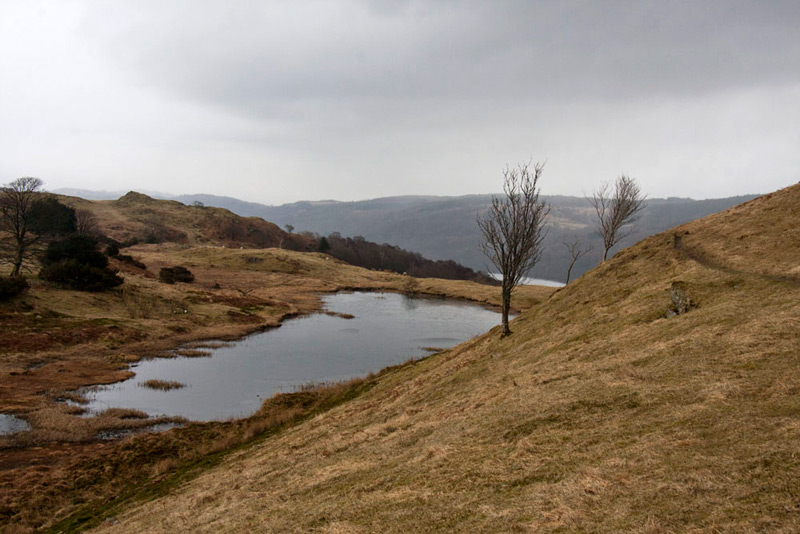
There was a clear path, and using his GPS, Dad was able to see that it went in the desired direction. After a while it bent away right round a hill, to reveal Long Moss Tarn nestling in its little valley. Its name means long marsh, as evidenced by it being silted up and overgrown at the southern end. Measuring about 730ft by 107ft, it is just 3ft deep. The outfall is Moor Gill, that runs into Coniston Water part of which can be seen behind the prominent tree.
As we strolled on along the path that can be seen in the right of the shot above, Little Eric said, "it's about time we had our picture taken. After all we have to appear in the story of each adventure, at least once."
"Quite", added Allen firmly.
Getting towards the end of the hill, Uncle Eric stopped to take a picture of the tarn, so Dad said, "OK, go and settle on the bank there and I will take your picture."
Walking on, the path descended towards the east end of the tarn, and we could see the outfall Moor Gill, and to the right a continuing path.
"Well, the gill ends up in Coniston Water, so that path to its right must be the route we want", said Uncle Eric.
Clear all the way, the path meandered steadily down, at one point providing a nice view south of Coniston Water.
Finally at lake level, we reached the junction with the Cumbria Way, where we turned right (south) beside the lake, walking the rough path to arrive at the jetty at Sunny Bank, used by the Coniston Launch. At the time of writing, the jetty had partly collapsed into the lake! Looking at their website, it is to be hoped that it is repaired in time for the start of the 2013 service on 1st May.
Here the wide path now veered away half right from the lake, climbing steadily by the wall on the left, to reach a gate at a wall corner. Through this the path continued on passing a small pool, that at the time seemed to be of no real significance, but now we wished that Dad had taken a picture, for reasons that will become clear below.
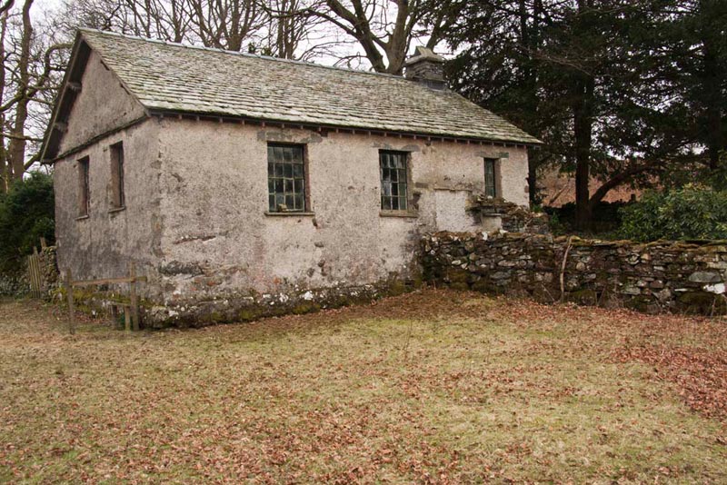
Just a few yards further we arrived at an old iron gate on the left into the grounds surrounding a small building that the map indicated was a disused church. The picture below is taken from the opposite side, but where we entered the grounds was the porch and entrance to the building.
"This is interesting " said Grizzly. "I wonder what the history of it is."
"You'll have look and see what you can find on the Internet", replied Allen.
When we got home Grizzly did as suggested, but all he could find was a photograph that referred to it as the former Church of Christ. He was rather despondent about finding so little, so went and asked Dad for help.
"OK lad, I will have a look", said Dad.
We were confident that Dad, if anyone, would be able to find more information and he did not let us down. It was built in 1678, as a meeting place of a Church of Christ, but was later classed as a Baptist Chapel, being last used as a place of worship in 1940. During it whole existence it has never been updated, candles still providing any illumination. Baptism was by total immersion, and reading the information, it was clear that the pool we had passed was indeed the baptismal pond. The wooden steps that the candidate and basptiser would have used to enter the water together, have however long disappeared. Much more information and many more photographs can be found by clicking the link - Sunny Bank Chapel
Descending the field beyond and passing through a gate, it was just a short way along the track to the road by Sunny Bank Farm.
Shaun said, "we go left crossing the bridge over the Torver Beck, then immediately right by that signposted gate."
The route climbed quite steeply by the substantial wall on the left, on the other side of which was Tyson Wood. At the top the wall swung left and we just kept on beside it all the way until we reached the lane by the gate to Stable Harvey Farm, once again. It was raining now as had been expected by the weather forecast. The rest of the walk was the reverse of our outwards route this morning, so we dived into the rucksack to keep dry.
It had been a interesting walk, over ground none of us had been to before, and so another part of Lakeland had been explored.
As we strolled into the car park, Dad and Uncle Eric's thoughts turned to food and where to go for lunch.
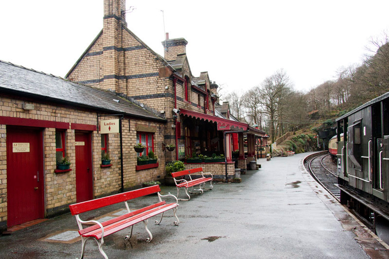
"How about going to Haverthwaite Station again", suggested Dad. "It was good food and very reasonable price too."
"An excellent idea", replied Uncle Eric. "Just the sort of place I like to support.
So once ready, Dad followed Uncle Eric, as he knew a short cut through some country lanes, and soon we were pulling into the car park. Our picnic now beckoned for us and we sat on the back seat to enjoy the sandwiches, Grizzly's delicious scones and cake, all with warming mugs of tea. Lovely.
Meanwhile Dad and Uncle Eric headed off to the cafe in the station building, and we called out our goodbyes to Uncle Eric, thanking him for taking us on a lovely walk.
It was about 13.30 and they were just in time for the Winter Warmer menu, as they stopped serving very soon afterwards.
"So what did you have", asked Tetley as Dad drove us home afterwards.
Dad replied, "we both had the pate with garlic bread to start, then Uncle Eric had chicken curry and I had scampi chips and peas, and of course tea to drink.
"You didn't have a pudding?" said Little Eric, in a surprised tone.
"Oh yes", Dad replied. "I had lovely ginger sponge and custard."
"Well I'm not surprised", responded Grizzly.
"It was such good value too, just £5 for two courses and £7 for three, plus extra for the tea of course", went on Dad. "I have been four times now this winter, twice with Uncle Brian and twice with Uncle Eric. Once it gets to Easter they are stopping this menu, but it will be back on after the summer, when the running season for the trains ends, so there will maybe be more visits then.