All was well. The tea and cakes had arrived courtesy of Shaun, Grizzly and Little Eric.
"What are the cakes today?", asked Allen, as he helped Shaun fill the mugs and pass them round.
"Thanks pal", said Grizzly. "From me there are scones with butter and raspberry jam. There are a choice, either fruit or cherry and ginger."
"I just love the latter", cried Southey helping himself.
Meanwhile Little Eric, said, "it's chocolate caramel shortbread from me."
"Super", cheered Shaun, taking a piece. Then after a bite, he went on, "it is scrumptious pal. Thanks."
There were murmurs of contentment from us all, so our thoughts then turned to walking.
"Dad has said he will take us out on Thursday", remarked Shaun.
Allen picked up the iPad and after a few taps, "the weather looks to be OK, dry but not terribly sunny."
"So then we need to come up with a plan", mused Tetley.
Little Eric replied, "We know that Southey will never complete the Lakeland challenges and it is far from certain whether I will. Then looking at Southey he went on, "there is perhaps one small challenge that you may be able to complete, to add to the Bowland Fells. That is the fells in Wainwright's Limestone book. Dad repeated a few for me, which gave you a start and recently we have been up Ingleborough and Pen-y-ghent."
"That sounds a great idea", cheered Southey. "Provided of course Dad is agreeable."
"So then with that in mind, what were you going to suggest?", went on Allen.
"I wondered about Great Coum from Dent", replied Little Eric.
"It will be the fourth time some of us have been up. remarked Tetley, "The last two were along the ridge from Gragareth, so it was back on 2005 that we did the route via Flinter Gill."
"My, that long ago", said Allen. "So an ascent by this route again is long overdue." He then drained his mug and taking the book said, "I'll go and see what Dad thinks about this climb and about completing the Limestone book for you Southey."
"Oh I do hope Dad will like the idea", said Southey worriedly.
He need not have worried. Allen was soon back. Great Coum is on, and Dad is happy to revisit the other Limestone summits."
"Great", cheered Little Eric, raising his mug, "here's to Thursday."
The Walk
Dad had said we were setting off between 09:00 and 09:30, so we got up in good time to pack the picnic.
As forecast it was a dry rather cloudy day, with light winds, but that had a cold edge coming from the east.
The route was up the Lune Valley to Kirkby Lonsdale, then along the Sedbergh road, turning off to drive through the village of Barbon. As we passed the church, Allen called out, on the right is Mr Williamson's where you get your delicious marmalade and chutney."
"It's the only place to go", replied Dad. "Homemade in his kitchen and using the finest ingredients. I can't remember when I first bought some preserves, but it is more than 10 years ago. Then the cost was just 50p a jar. What is so wonderful is that all the proceeds go to charity."
"I recall that when we passed back in 2005 on our way to the first ascent of Great Coum, Mr Williamson was looking out of the window and commented to his wife, 'I'm sure that was the gentleman from Morecambe.'", related Tetley.
"I recall calling for supplies on the way home, and I was able to confirm that", said Dad.
So out of the village the road climbed steeply for a short way. Single track, it led on through Barbondale, with the slopes of Middleton Fell to the right. Finally we dropped down to Gawthrop and at the junction went right to soon be in Dent. We jumped out and settled in Dad's rucksack, then soon ready this was shouldered and Dad strode off.
We go along the lane opposite", instructed Shaun.
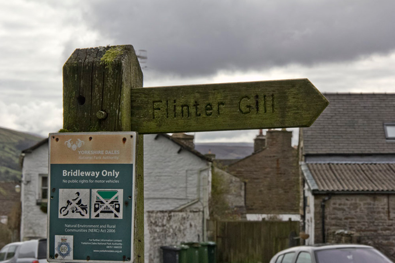
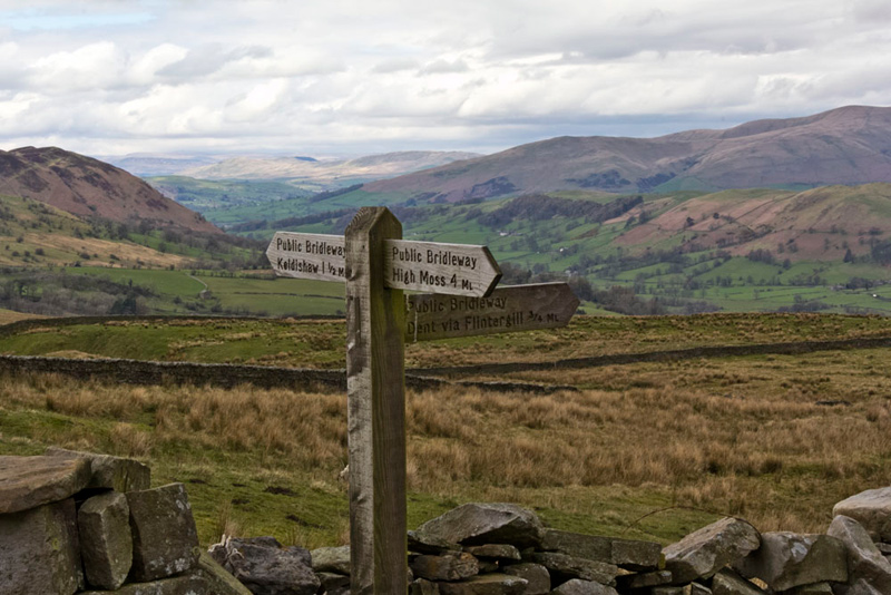
Shortly there was an open gassy area to the left by which was this sign for the route...
...on between the charming cottages.
Round the corner and passing the last house the tarmac ended, to continue as a rough stony track that climbed quite steeply to the right of the ravine of Flinter Gill.
Southey called out, "there is a sign on that tree, reading Dancing Flags. What is that about?"
"We have written about this in a past story, when we came up here with Uncle Eric", said Grizzly.
Taken from that story, for readers and Southey's sake here is the explanation -
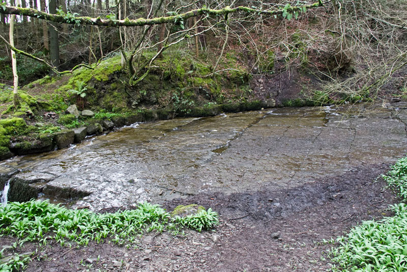
The 'Dancing Flags', are a large expanse of flat natural rock slabs that were used for centuries by local weavers for 'waulking' their newly-woven lengths of cloth, or 'webs' as they were called. This was done by first wetting the fabric thoroughly and then treading it with bare feet, causing it to shrink slightly and 'felt up' to create a much thicker and therefore much warmer material. At one time this was a universal practice and in many places became known as 'dancing the web' - hence the name of the stones.
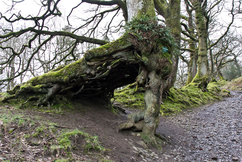
Soon another sign caught Southey's eye. "The wishing tree", he said.
As you can see the trunk and roots have formed it in such a way to create an arch. "I can remember the story here". piped up Grizzly. "It is that if you make a wish and then go round through the arch three times in a clockwise direction, your wish is then supposed to come true."
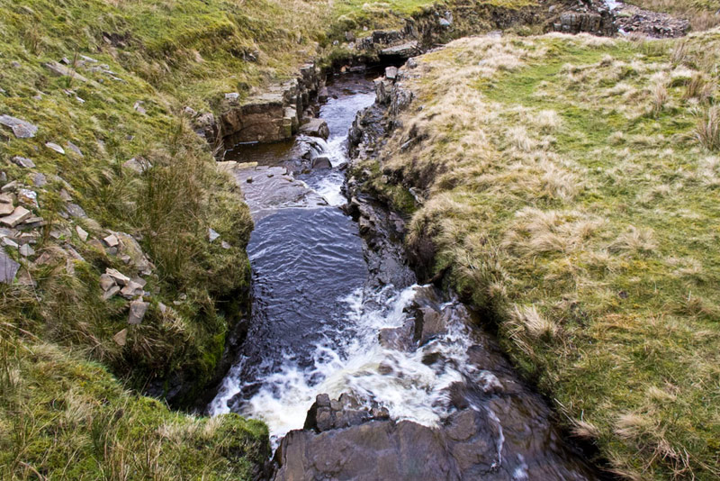
For most of the time the beck was in a ravine, and not in view from the path, but as we gained height it could be seen dropping in steps.
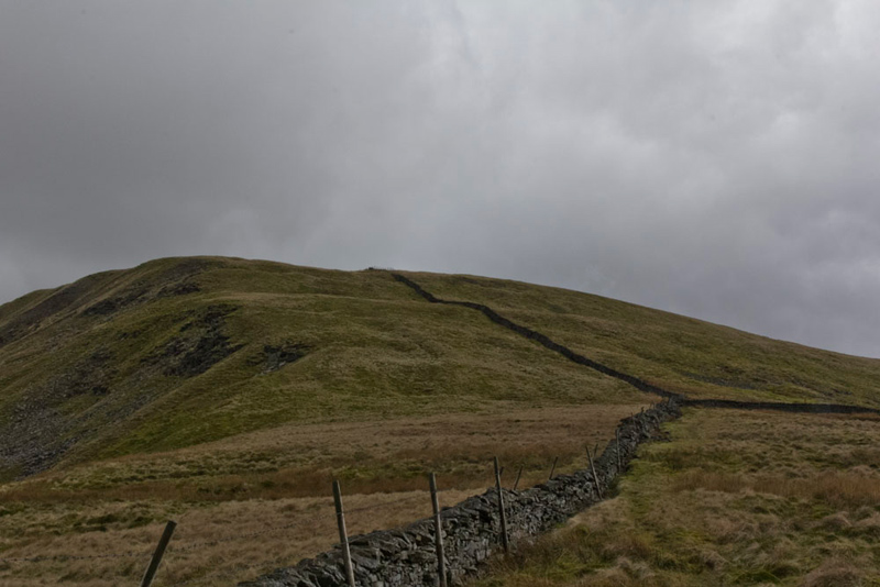
Finally leaving the woodland behind the last section was over open more grassy terrain to the junction with Green Lane, that is an old drovers road to Ingleton running from the Barbondale road.
Turning left, Shaun said, "we follow this for 2.5 miles."
The track was stony for the most part, but grassy at times and was very wet and muddy. "Lovely", commented Dad sarcastically as he squelched along.
"The recent rain has stopped the drying out process", said Tetley. "Surely we must get a dry summer."
Let's hope so", agreed Little Eric.
Further on Allen called out, "those cairns up on the hill are the Megger Stones, which we will visit later."
Shaun was taking note of the gates in the walls on that side, and said, "this one here looks a likely candidate for regaining the track after the descent. It is not the one Wainwright uses but will save some doubling back."
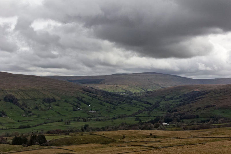
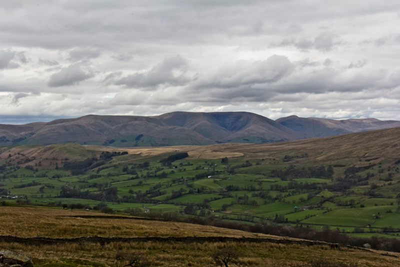
To the right the views opened out, Tetley saying, that is a lovely view of Dentdale." Then glancing at the map, "with Great Knoutberry Hill behind."
"Ooh I remember climbing that with Uncle Bob, from Dent Station", recalled Allen. "It was a very misty and damp day to start, and we could not see a thing as we climbed up the the fence to the summit. We managed to sit on the trig point, but had to be careful not to fall off into the water that surrounded it."
Passing a pool on the track, Southey asked, "there's something strange in that pool."
"It's frog spawn", replied Grizzly. "We've seen this in similar situations a few times, over the years."
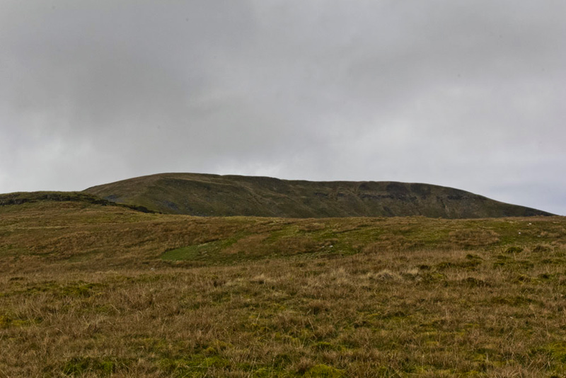
Pointing right, Tetley commented, "Southey, the ridge to the back is Great Coum."
"But we are walking past", he replied.
"I know", agreed Tetley, but to make it a circular walk we have to make the ascent to the ridge to the left looking from here."
"I seem to remember that in 2005 we could not find the gate referred to by Wainwright", said Allen.
"Yes lad, but perhaps we had not counted correctly the walls going up the fell that we have to pass", suggested Dad.
Shaun was following the map intently. "There is a gate here, but according to Wainwright we want one in the wall from the track after that next wall climbing the fell."
Well we should have taken that gate, as the one Wainwright refers to is just no longer there. In fact judging by the wall it looks like it never existed! Still the book was written in 1970.
"Darn!, said Dad, "we've done it again."
"Sorry Dad", replied Shaun.
"It's not your fault lad."
However fortunately or unfortunately, the wall have collapsed at one point. "OK, if I slip the rucksack off", said Dad, "I will be able crawl under the wire fence."
Distantly here, we saw two walkers traversing the upper slopes. The only other people today.
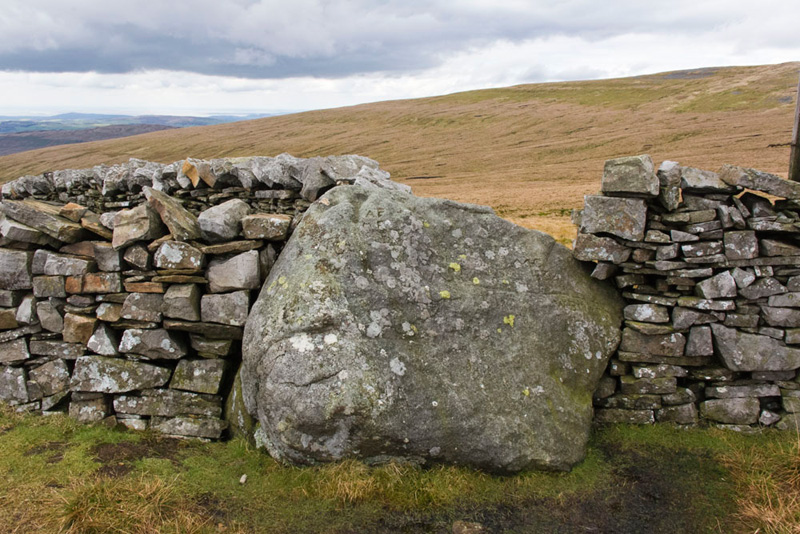
So Dad made his way across the trackless moor and then the final steep ascent to the ridge crossing to the wall that incorporates this boulder known as the County Stone. Wanting to know more, Allen looked it up when we got home and told us, "it once marked the meeting place of three county boundaries; Westmorland, North Yorkshire and Lancashire."
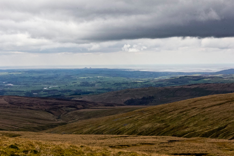
From here there was a fine view to Morecambe Bay, the towers of Heysham Nuclear Power Stations being seen in the centre. Waving our paws, we called out, "hello Uncle Brian."
"That's Ease Gill in the foreground", commented Shaun.
"Oh I well remember descending that with Uncle Bob", replied Dad. "It was ever so rocky and rough. I do not plan to do that again."
Now putting best foot forwards Dad set off right by the wall along the ridge. Seeing a stile in the wall, Shaun said, "we should cross to the other side here."
A steady climb took us over Gatty Pike, marked by this huge cairn on the far side of the wall.
"Shouldn't we be visiting that?" asked Southey.
It's not a summit, so there is no necessity", replied Allen.
Finally the flat summit area of Great Coum was reached. Checking the map, Shaun said, "we need to climb that stile in the cross wall, then go left to the wall corner."
Here there was a stile ahead and a cairn about 50 yards beyond. "Is that the summit?", asked Southey.
"Well lad, that is actually what Wainwright considers to be the summit, but the spot height on the OS map is just to the right by this wall", replied Shaun.
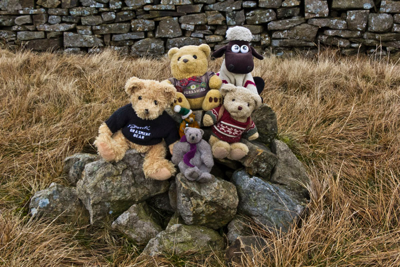
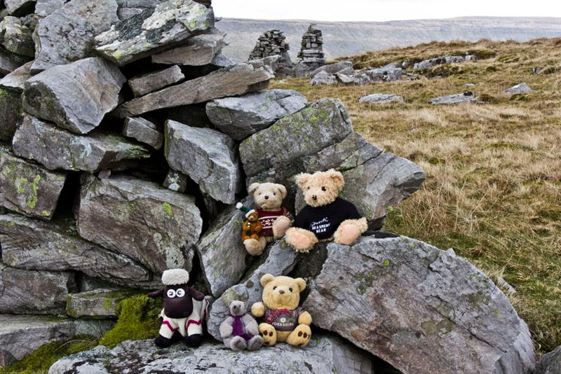
And sure enough, for the fourth time for some of us, we came to the cairn. Hopping out we balanced a bit precariously for our usual picture.
"For the descent, we need to be on the opposite side of this wall", said Shaun.
"OK lad", replied Dad. "I'll walk back to the corner to cross the stile, and we can visit the other cairn that Wainwright considered the summit."
This done, crossed back to the wall and made the steepish descent of Crag End, to climb a stile in the cross wall, and walk on.
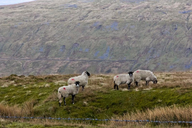
The wall bent left and we kept on beside it. So far Allen's luck was holding regarding sheep pictures, but Tetley said, "that group over the wall will make a nice shot, backed by the steep slopes of Aye Gill Pike."
"Grr", growled Allen.
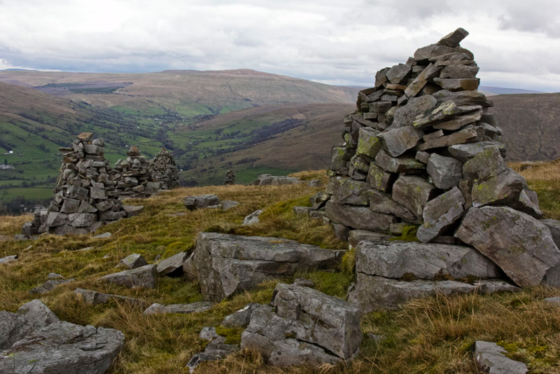
"Soon, the wall will turn down the fell", said Shaun. "There we keep on for the Megger Stones."
These are a collection of cairns some old and some of more recent origin.
The one in the foreground has a nice flat area, Tetley saying, "We can sit there for a picture."
"OK lads", agreed Dad.
"That's another fine view of the Howgills,", commented Little Eric.
"Yes lad. I've taken a few today, but this will be the best.
Ready for the off again, Shaun said, "Wainwright's instructions here are to double back to the wall and follow it down. However we can save having to do that by following the wall ahead. If I am right it will bring us to the gate we noted by the track."
He was spot on too. The gate was sunk in the mud and despite Dad's best efforts he could not free it, so just climbed over.
Turning left we followed our outward route, crossing Flinter Gill...
...to come to the signposted junction and so go right to descend to Dent.
"What a super walk!", exclaimed Southey."Thanks Dad and pals for doing it again."
"We've all enjoyed it", replied Grizzly.
So back at the car, Tetley said, "refreshment time? There's a cafe in the village"
"I know, but where else do I want to go but Elaine's."
Here Dad had a delicious scone with butter and jam and a slice of chocolate cake with a pot of tea. Elaine had been taking her dog Mia for a walk when we arrived and then went upstairs, so Dad went up to see her and had a nice chat.