EAMONT
BRIDGE, RIVER EAMONT & YANWATH from PENRITH
Summary
Date - 4th March 2008
Distance - 8 miles
Map - OL5
Start point -
Bluebell Lane car
park, Penrith (NY 513302)
The Walk
Tuesday dawned with blue skies,
sunshine and light winds, and could not have been more of a
contrast from the wild winds of Sunday when we had climbed
Whernside. We were glad the weather was fair, as Dad had arranged
to walk with Uncle Eric. We drove to Uncle Eric’s where Dad
left his car and then continued in Uncle Eric’s car. He took
us up the A6 now a quiet road but once the main road to Scotland.
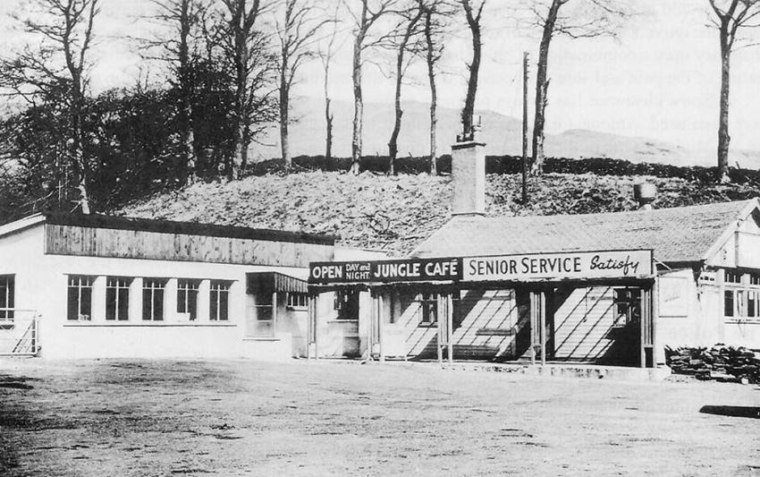
Passing a caravan sales site, Dad told us that this had once been
the Jungle Transport Café.
Open day and night is was the
stopping place for lorry drivers going up or coming down from
Shap where the road is over 1000ft above sea level. Indeed in
severe winter conditions when the road was closed the drivers had
to stay here until it was cleared. It must have been a gold mine.
Then one day the M6 motorway opened, and overnight their trade
disappeared.
No weather problems today and we
were soon at Penrith, a large market town in north Cumbria on the
eastern edge of the Lake District, and our starting point.
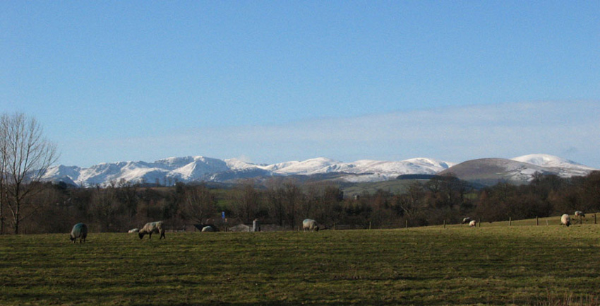
Leaving the car park we walked along the road to come to the busy
A66 dual carriageway. This was crossed safely and in a few yards
this superb view of the snow capped Helvellyn range of the
Lakeland Fells came into view.
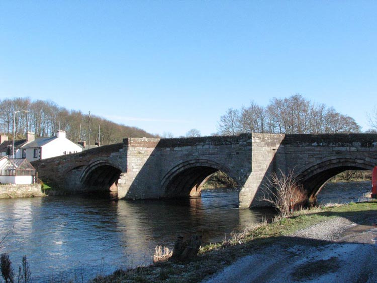
A short distance along the A6
brought us to the village of Eamont Bridge. Here the road crosses
the River Eamont by this magnificent bridge dating from the 16th
century.
The river starts as the outfall
from Ullswater in the Lake District and flows eventually into the
River Eden. We were to follow this river upstream quite a lot on
today’s walk. Now walking by the river for a while we then
went across a field to come to a quiet road beside the noisy M6
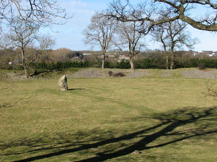
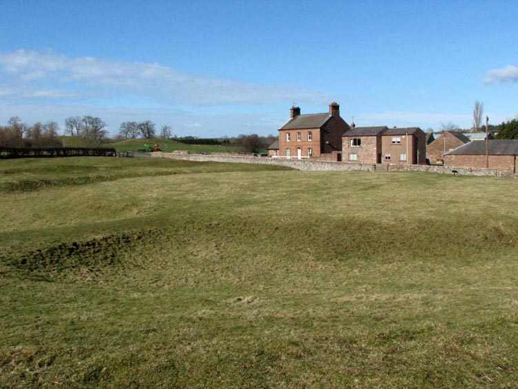
motorway. Just a little way along we went through a gate to visit
Maybergh Henge a massive 16ft high circular embankment of stone
rubble and grass. It is believed to date back to 2500BC and to
have been the first meeting place for a large prehistoric
community in the Eden Valley. In the centre is a large standing
stone – one of seven that were present in the 18th
century.
We found it hard to comprehend that
this had been here for 4500 years. This was not the end of our
exploration of such sites today and just a short distance away
and actually beside the A6 road is another ancient fortification
fancifully named King Arthur’s Round Table dating from 1800BC.
This was protected by a deep ditch and the spoil was embanked. It
too is believed to have been another meeting place.
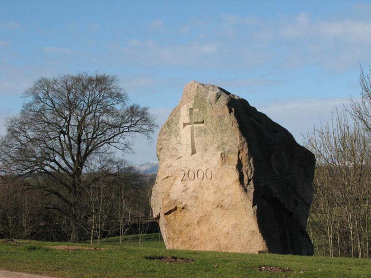
In between this and Maybergh Henge
is this huge 50 tonne block of Shap Granite…
It is a Millennium Monument and the
Bishop of Penrith dedicated it on 2nd July 2000 at the
culmination of the Eden Millennium Festival. The site was chosen
because its association with the neighbouring Henges. The granite
is 330 million years old and the Monument is intended to last
thousands of years.
In a trench around the base are
buried about 2000 small stones decorated mostly by primary school
children of Eden and placed there at the dedication service as
birthday presents of Jesus’ 2000th birthday.
There are carved symbols on three
sides – an Alpha, a Cross with the number 2000 and an Omega.
The Alpha and the Omega are the first and last letters of the
Greek alphabet and represent the beginning and the end, the past
and the future, God the creator and God the Holy Spirit. The
Cross and the 2000 represent the present, 2000 years of
Christianity and Jesus Christ our Saviour alive with us today.
All these sites and the Monument
was rather a lot for little Lads like us to take in but it had
been really fascinating to see.
Returning past Maybergh Henge we
passed under the motorway and then over fields to come to a house
called The Grotto below the main railway line. Sadly no trains
came along while Uncle Eric was photographing the railway bridge.
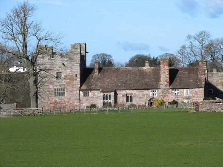
Once under this and a little way along we saw ahead the
picturesque Yanwath Hall a fortified farmhouse.
This wonderfully preserved Penrith
sandstone fortress was a protective bastion against the marauding
Scots who poured over the Border. The squat pele tower was built
in 1322 and the courtyard buildings added in the 15th
century. See - www.visitcumbria.com/pen/yanhall.htm
The walk now took us over fields
first with the River Eamont far below. Then eventually we dropped
down a steepish slope to reach a plank bridge over a stream and
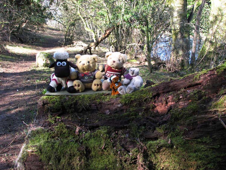
then through delightful woodland beside the rushing river. Here a
convenient fallen tree trunk provided a good seat for Uncle Eric
and Dad to have their lunch. We had ours sitting nearby where we
could watch the river. Afterwards Dad took our photo sitting on
the tree trunk.
The path led on out into a pasture
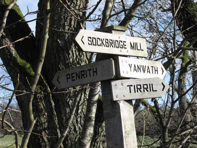
and we reached this rather complicated signpost…
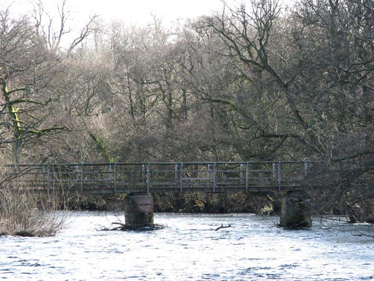
We had come from the Yanwath
direction, and our route now was the Penrith direction via a
wooden footbridge over the river. The sandstone piers it rests on
are much older.
Still following the river we passed
into more woodland below some towering sandstone cliffs on a
narrow path that eventually descended down some steps at a point
where there is an island in the river that is known as Stainton
Island. This led via a stile to a track that we climbed up to
cross a road and continue on the track to emerge at the village
of Stainton. Here at the farm called Greystone House there is a
café that Dad has frequented many times over the years but not
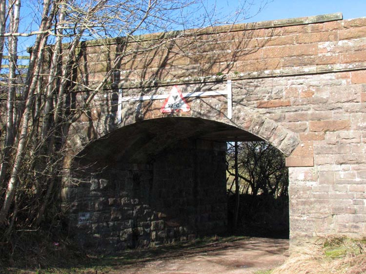
today, as we had to keep on towards Penrith. Soon a narrow steep
by-road was reached that brought us once again to the A66 dual
carriageway. Again Uncle Eric and Dad got us safely across and we
walked on a track that passed under this bridge.
This once carried the long closed
railway that ran from Penrith west to Keswick and Cockermouth.
There is a plan to reopen it to Keswick, as it would be of great
benefit for tourists, but whether it ever happens remains to be
seen. Rather forlornly the missing coping stone still lies
amongst the grass.
After a short walk along the track
we took a gate to cross a number large fields and a narrow road.
As we reached the high point Penrith came into view, as did the M6
motorway that we had to cross. This we did via a footpath at the
side of the railway viaduct. It was windy here and Dad sensibly
held on to this cap! Something he should have done too on our
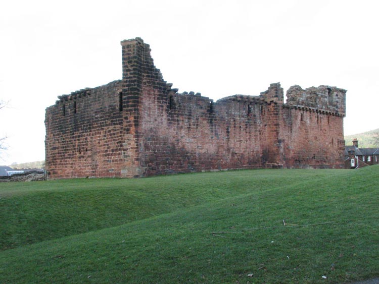
next walk, but that is another story. We were soon in the town
and we saw our last historical site of the day – the ruins
of Penrith Castle.
Walking through the park in which
the castle stands soon brought us to the car park. We hopped out
and settled in the car, and had another picnic while Uncle Eric
and Dad went off in search of refreshment. What a surprise I hear
you say. They went to Bewicks restaurant and had a pot of tea and
delicious scone with butter and jam. This building has
associations with Thomas Bewick (1753 – 1828) the famous
wood engraver. As we rode home we reflected on all the
interesting things we had seen today on what had been a wonderful
adventure.